File:NC 19-7.jpg
Jump to navigation
Jump to search

Size of this preview: 783 × 600 pixels. Other resolutions: 313 × 240 pixels | 627 × 480 pixels | 1,003 × 768 pixels | 1,280 × 981 pixels | 2,560 × 1,961 pixels | 5,296 × 4,057 pixels.
Original file (5,296 × 4,057 pixels, file size: 6.38 MB, MIME type: image/jpeg)
Captions
Captions
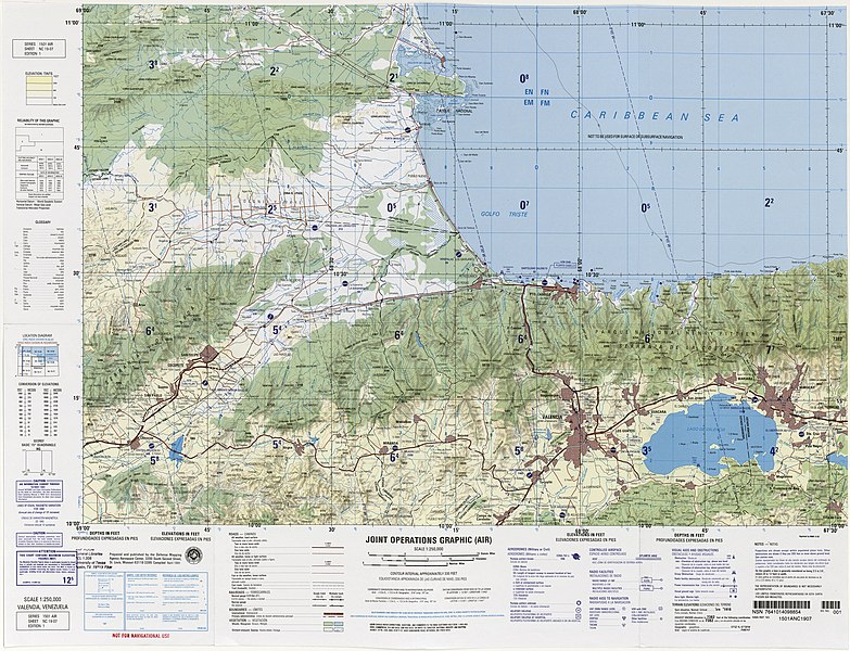
Aeronautical chart from Joint Operations Graphic by the U.S. National Imagery and Mapping Agency, at scale 1:250,000.
Summary[edit]
| Description |
Español: Cartas aeronáuticas del Joint Operations Graphic creados por el U.S. National Imagery and Mapping Agency, a escala 1:250,000.
English: Aeronautical chart from Joint Operations Graphic by the U.S. National Imagery and Mapping Agency, at scale 1:250,000. |
| Date | |
| Source | Perry-Castañeda Library Map Collection / The University of Texas at Austin |
| Author |
U.S. National Imagery and Mapping Agency |
| Ref. | NC 19-7 |
| Nombre | VALENCIA |
| Área de interés | Valencia, Maracay, Puerto Cabello, Morón, Chivacoa, San Felipe, Nirgua, Tucacas, Chichiriviche |
Licensing[edit]
This image is a work of the United States National Geospatial-Intelligence Agency or one of its predecessor agencies. As a work of the U.S. federal government, the image is in the public domain.
|
 |
File history
Click on a date/time to view the file as it appeared at that time.
| Date/Time | Thumbnail | Dimensions | User | Comment | |
|---|---|---|---|---|---|
| current | 13:30, 10 July 2022 | | 5,296 × 4,057 (6.38 MB) | Wguayana (talk | contribs) | Uploaded a work by U.S. National Imagery and Mapping Agency from U.S. National Imagery and Mapping Agency with UploadWizard |
You cannot overwrite this file.
File usage on Commons
The following page uses this file: