Atlas of Belgium
Hopp til navigering
Hopp til søk
Land i Europa: Albania · Andorra · Armenia‡ · Aserbajdsjan‡ · Belarus · Belgia · Bosnia-Hercegovina · Bulgaria · Danmark · Estland · Finland · Frankrike‡ · Georgia‡ · Hellas · Irland · Island · Italia · Kasakhstan‡ · Kroatia · Kypros‡ · Latvia · Liechtenstein · Litauen · Luxembourg · Malta · Moldova · Monaco · Montenegro · Nederland‡ · Nord-Makedonia · Norge · Polen · Portugal‡ · Romania · Russland‡ · San Marino · Serbia · Slovakia · Slovenia · Spania‡ · Storbritannia · Sveits · Sverige · Tsjekkia · Tyrkia‡ · Tyskland · Ukraina · Ungarn · Vatikanstaten · Østerrike
Spesifikk status: Akrotiri og Dhekelia‡ · Færøyene · Gibraltar · Guernsey · Jersey · Man · Svalbard – Begrenset anerkjennelse: Abkhasia‡ · Gagaus · Kosovo · Nord-Kypros‡ · Sør-Ossetia‡ · Transnistria
‡: delvis i Europa
Spesifikk status: Akrotiri og Dhekelia‡ · Færøyene · Gibraltar · Guernsey · Jersey · Man · Svalbard – Begrenset anerkjennelse: Abkhasia‡ · Gagaus · Kosovo · Nord-Kypros‡ · Sør-Ossetia‡ · Transnistria
‡: delvis i Europa

|
Wikimedia Commons Atlas of the World The Wikimedia Atlas of the World is an organized and commented collection of geographical, political and historical maps available at Wikimedia Commons. Diskusjon • Update the atlas • Index of the Atlas • Atlas in categories • Other atlases on line |
The introductions of the country, dependency and region entries are in the native languages and in English. The other introductions are in English.
|
| ||||||||||||||||||||||||||||||||||||||||||||

General maps

|
Kaart van België Carte de Belgique (en néerlandais) Karte Belgiens (niederl.) Map of Belgium (in Dutch) |

|
Carte de Belgique (en français) Kaart van België Karte Belgiens (franz.) Map of Belgium (in French) |

|
Map of Belgium (in English) Kaart van België Karte Belgiens (engl.) Carte de Belgique (en anglais) |

|
Map of Belgium (in English) Kaart van België Karte Belgiens (engl.) Carte de Belgique (en anglais) |
Federalism in Belgium

|
Administratieve verdeling van België Provinces de Belgique Die Provinzen Belgiens Administrative divisions of Belgium |

|
Gewesten en provincies Régions et provinces Regionen und Provinzen Regions and provinces |

|
Gewesten en provincies Régions et provinces Regionen und Provinzen Regions and provinces |

|
Communautés de la Belgique Gemeinschaften Belgiens Community's of Belgium |

|
Vlaamse Gemeenschap Communauté flamande fr:néerlandais néerlandophone Flemish Community, Dutch speaking |

|
Gewest Vlaanderen Région flamande Flemish region |

|
Communauté française de Belgique Franse Gemeenschap French Community |

|
Wallonie Gewest Wallonië Wallonische Region Walloon region |

|
Deutschsprachige Gemeinschaft Communauté germanophone de Belgique Duitstalige Gemeenschap German-speaking Community |

|
Die 9 Gemeinden der Deutschsprachigen Gemeinschaft Communes germanophones Municipalities |

|
Région de Bruxelles-Capitale Gewest Brussel-Hoofdstad Brussels-Capital region |

|
Communes de Bruxelles Gemeenten van het Gewest Brussels municipalities |

|
Faciliteitengemeenten Communes avec facilitées linguistiques (en néerlandais) Gemeinden mit Spracherleichterungen: Fazilitätengemeinden (niederl.) Municipalities with language facilities (in Dutch) |

|
Faciliteitengemeenten (in het Frans) Communes avec facilitées linguistiques Gemeinden mit Spracherleichterungen: Fazilitätengemeinden (auf franz.) Municipalities with language facilities (in French) |

|
Faciliteitengemeenten (in het Duits) Communes avec facilitées linguistiques (en allemand) Gemeinden mit Spracherleichterungen: Fazilitätengemeinden (auf deutsch) Municipalities with language facilities |

|
Faciliteitengemeenten (in het Engels) Communes avec facilitées linguistiques (en anglais) Municipalities with language facilities |
-
 Vlaamse provincies
Provinces flamandes -
 Provincie Antwerpen
Anvers
Province of Antwerp -
 Provincie Limburg
Limbourg
Province of Limburg -
 Province of East Flanders
Provincie Oost-Vlaanderen
Province de Flandre orientale -
 Province of Flemish Brabant
Provincie Vlaams-Brabant
Province de Brabant flamand -
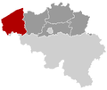 Province of West Flanders
Provincie West-Vlaanderen
Province de Flandre occidentale


-
 Walloon provinces
Provinces de Wallonie
Waalse provincies -
 Province of Walloon Brabant
Province du Brabant Wallon
Waals Brabant -
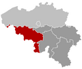 Province of Hainaut
Province de Hainaut
Henegouwen -
 Province of Liège
Province de Liège
Luik -
 Province of Luxembourg
Province de Luxembourg
Luxemburg -
 Province of Namur
Province de Namur
Namen


History maps
This section holds a short summary of the history of the area of present-day Belgium, illustrated with maps, including historical maps of former countries and empires that included present-day Belgium.
Early history

|
Since 600 BC present-day Belgium is inhabited by Celtic tribes, like the Belgae. This map shows the possible extent of (proto-)Celtic influence 800-400 BC De Kelten in Europa. Oker: Kernbereik Noord-West-Alpine Hallstattcultuur (ca. 750–500/450 v. Chr.) groen: Uitbreiding La-Tène-cultuur, bzw. oranje: de Keltische taal (3. Jh. v. Chr.) |
The Romans
| 57/51 BC-395: Roman Empire - includes present-day Belgium ► Roman Empire |

|
Between 57 and 51 BC the Belgae are defeated by the Roman Empire. The area becomes the Roman province of Belgica and is romanized. This map shows the Roman Empire in 50. De territoriale ontwikkeling van de Romeinse Republiek en het Romeinse Rijk. |

|
Around 256 the Germanic tribe of the Franks enter Belgica and since 296 they rule the area as defender of the border of the Roman Empire. This map shows the invasions of the Roman Empire 100-500. Invallen in het Romeinse Rijk 100-500 |
| 395-486: Western Roman Empire - includes present-day Belgium ► Roman Empire |

|
After the division of the Roman Empire, Belgica become part of the Western Roman Empire. This map shows the Empire in 395. (Het Westromeinse Rijk rond 395) |
The Franks
| 481-843: Frankish Empire - independent monarchy including present-day Belgium ► Frankish Empire |

|
The Frankish position culminate in the forming of the Frankish Empire. The Frankish Empire becomes an independent state, but in 639 the country is divided in Austrasia and Neustria. Both kingdoms are reunited in 719 and the Empire develops further until the rul of Charlemagne. (Na de val van het West-Romeinse Rijk nemen Germaanse stammen als de Franken de controle over het gebied over. Uiteindelijk wordt België deel van het Frankische Rijk. Zie de Atlas van het Frankische Rijk.} |
| 843-870: Middle Frankish Empire - independent monarchy including the present-day Netherlands ► Frankish Empire |
| [[|border|251x400px]] | After the division of the Frankish Empire in the Treaty of Verdun the area became part of the Middle Frankish Empire. Het Verdrag van Verdun |

|
This map compares the Treaty of Verdun (843) with the Treaty of Meerssen (870) Het Verdrag van Verdun 843 en het Verdrag van Meersen 870 |
| 843-962: East Frankish Empire - independent monarchy, including present-days Belgium ► Germany |

|
This treaty leads to the most parts of the area becoming part of the East Frankish Empire. Verdeling van het Frankische Rijk 870 |
Part of the Holy Roman Empire
| 962-1648: Holy Roman Empire - independent monarchy, including most of present-days Belgium ► Germany |

|
In 925 the area is annexed to the Eastern Frankish Empire, later continued by the German Empire. Only the western part becomes part of the Western Frankish Kingdom, later continued by the France. This map shows Central Europe between 919-1125 Midden-Europa 919-1125 |
| [[|border|251x400px]] | This map shows the Holy Roman Empire in the 10th century. Het Heilige Roomse Rijk in de 11e eeuw |

|
The house of Bavaria-Straubing comes in 1346 in the possession of Hainaut, which is in a personal union with the County of Holland. Beierse bezittingen in Henegouwen en Holland |

|
In the feudal German Empire and France the duchies and counties, together known as the Netherlands, come between 1384 and 1451 under the rule of Burgundy. Holland and Hainaut become Burgundian in 1436. The bishop-principality of Liege remains separate. The Holy Roman Empire in the 14th century Het Heilige Roomse Rijk in de 14e eeuw |
| [[|border|251x400px]] | At the same time, the city of Bruges plays an important role in the Hanseatic League De Hanze |

|
Bruges is part of the hanseatic trade routes De Hanze-routes |

|
This map shows the Low Countries in 1477, largely under control of the Burgundians. De Lage Landen in 1477 |
-en.png)
|
The Burgundian possessions come under control of the Habsburgians since 1506. This map shows the Low Countries as part of the Holy Roman Empire. De Nederlanden als deel van het Heilige Roomse Rijk |

|
And this map shows the Low Countries as part of Habsburgian ruled Europe, as does the following map. It was the empire of Charles I/V. Europa onder Karel V Castile/Castillië Aragon Burgundy/Bourgondië Habsburg
|

|
Separation

|
After the division of the Habsburgian countries in 1555 the Netherlands come under control of Habsburg-ruled ► Spain. In resistance to the Spanish rule, the northern Netherlands form the Union of Utrecht, followe dby the formation of the Union of Arras De Unies van Utrecht en Atrecht |

|
In 1568 a rebellion against the Spanish occupation starts. This map shows the area ruled by the Spanish king around 1580 (Netherlands in blue) on a map showing modern-day state borders. De bezittingen van de Spaanse koning rond 1580 (De Nederlanden in blauw) |

|
The northern part of the ► Netherlands develop as the Republic of the United Netherlands into a de facto independent state. The southern parts remain at the same time under Spanish rule as the Spanish Netherlands. This map shows the Netherlands from 1559-1608. De Nederlanden |

|
This map shows both the United and the Spanish Netherlands. De Verenigde en de Spaanse Nederlanden |

|
The Spanish Netherlands are at the same time part of the Holy Roman Empire, as are formally the United Netherlands to. Het Heilige Roomse Rijk in 1630 |

|
In 1713 the Spanish Netherlands are acquired by ► Austria: the area gets known as the Austrian Netherlands. After a revolution in 1789 the United Belgian States are founded, but already in 1790 Austrian rule is restored. De Oostenrijkse Nederlanden |
French rule
| 1794-1815: French Empire - includes present-day Belgium ► France |

|
In 1794 France invades the Austrian Netherlands and incorporates them together with Liege into France. De Zuidelijke Nederlanden als deel van het Franse Rijk in 1811. |

|
The Southern Netherlands under French control Europa onder Napoleon |
Part of the Netherlands
| 1815-1831: Kingdom of the Netherlands - includes present-day Belgium ► the Netherlands |

|
After the French defeat in 1815, the Austrian Netherlands are united with the Netherlands and Liege into the United Kingdom of the Netherlands. This is a constitutional monarchy with real power in hands of the King. ► Moresnet becomes a condominium with ► Prussia. Het Verenigde Koninkrijk der Nederlanden (1815-1831) |

|
A revolution in the Southern Netherlands leads to various partition plans. This map shows the Talleyrand partition plan. Het Talleyrand verdelingsplan |
Kingdom of Belgium

|
1831-present[1]: Kingdom of Belgium (Royaume de Belgique) - independent country |
.png)
|
At the end, Belgium secedes from the Netherlands. This map shows the Netherlands, Belgium, Luxembourg and Limburg in 1839. 1, 2 and 3 United Kingdom of the Netherlands (until 1830) 1 and 2 Kingdom of the Netherlands (after 1830) 2 Duchy of Limburg (In the German Confederacy after 1839 as compensation for Waals-Luxemburg) 3 and 4 Kingdom of Belgium (after 1830) 4 and 5 Grand Duchy of Luxembourg (borders until 1830) 4 Province of Luxembourg (Waals-Luxemburg, to Belgium in 1839) 5 Grand Duchy of Luxembourg (German Luxemburg; borders after 1839) In blue, the borders of the German Confederacy Splitsing van de Nederlanden. 1 en 2: Koninkrijk der Nederlanden, waarvan 2 Limburg, lid van de Duitse Bond. 3 en 4: Koninkrijk België, inclusief 4 Waals Luxemburg. 5: Groothertogdom Luxemburg, in personele unie met Nederland, lid van de Duitse Bond, maar exclusief 4 Waals Luxemburg. |

|
Le territoire belge entre 1830 et 1839. |

|
At the start of the 20th century, Belgium controlled a colonial empire, especially Belgian Congo. Het Belgisch koloniaal rijk |

|
In 1940 Belgium is invaded and occupied by Germany. Hubert Pierlot (Prime Minister of Belgium) and his government go into exile in London. Belgium is liberated in 1944. See the Atlas of World War II. |
|
|
An important constitutional reform occurrs in the summer of 1993, changing Belgium definitively from a unitary to a federal state. This makes Belgium is a federation of Dutch-speaking Flanders, francophone Wallonia and bilingual Brussels. |
History of other entities
Moresnet
| 1816-1919: Moresnet (Neutraal Moresnet, Moresnet neutre, Neutral-Moresnet) - Condominium |

|
The Netherlands form in 1816 together with Prussia the condominium of Moresnet. The Netherlands position is continued by Belgium after its independence. The condominium exists until the end of World War I. Neutraal Moresnet Das preußisch-niederländische, später preußisch-belgische Kondominium Neutral-Moresnet. |
Old maps
This section holds copies of original general maps more than 70 years old.

|
The 17 Netherlands, depicted as Leo Belgicus De 17 Nederlanden als Leo Belgicus |

|
Leo Belgicus by Josse de Hond Leo Belgicus door Josse de Hond |

|
Blaeu map of the Low Countries in 1635 De Lage Landen door Blaeu in 1645 |

|
Brabant by Ioan Blaeu, 1645 Hertogdom Brabant |

|
Map of the Southern Netherlands by Herman Moll, 1740 |

|
Belgium and the Netherlands in 1905 |
Other maps

|
the Benelux states |

|
Old Dutch language Het Oudnederlands |

|
Dutch language in Europe Nederlands in Europa |

|
Dutch dialects Nederlandse dialecten |

|
Dutch dialects Nederlandse dialecten |

|
Low Franconian dialects Nederfrankische dialecten |

|
Low Franconian dialects Nederfrankische dialecten |

|
Linguistic map of Wallonia Taalkaart van Wallonië |

|
Linguistic map of Wallonia Taalkaart van Wallonië |
Satellite maps

|
Satellite map Satellietfoto |
Notes and references
|
General remarks:
|