The introductions of the country, dependency and region entries are in the native languages and in English. The other introductions are in English.
| |
|
Atlas-country
|
Malaya
|
|
|
|
|
|
|
|
Malaya
|
|
|
|
| English
|
Malaya - Malaya
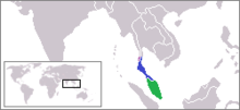
The Malaya or the Federation of Malaya was a federation of 11 states (nine Malay states namely Johor, Kedah, Kelantan, w:Negeri Sembilan:Negeri Sembilan, Pahang, Perak, Perlis, Selangor, Terengganu and two of the British Straits Settlements, Penang and Malacca), that existed from 31 January 1948 until 16 September 1963. The Federation became independent on 31 August 1957,[1] and in 1963 named as Malaysia.[2]
|
|
|
|
| Short name
|
Malaya
|
| Official name
|
Malaya
|
| Status
|
|
| Location
|
South East Asia
|
| Capital
|
Kuala Lumpur
|
| Population
|
inhabitants
|
| Area
|
132,364 square kilometres (51,106 sq mi)
|
| Major languages
|
Malay
|
| Major religions
|
Muslim
|
| More information
|
Malaya, Geography of Malaya, History of Malaya and Politics of Malaya
|
| More images
|
Malaya - Malaya (Category).
|
|
 Emblem of Malaya Emblem of Malaya
|
 Flag of Malaya Flag of Malaya
|
| Malaya
|
References


