Bank Foot Metro station
Jump to navigation
Jump to search
English: Bank Foot 55°00′50″N 1°40′40″W / 55.013891°N 1.677802°W is a station on the Green Line of the Tyne and Wear Metro, on the north western edge of urban Newcastle. The name refers to the area Kenton Bank Foot - the site of the former Kenton Bank railway station is directly to the west - although the station is in the southern corner of Castle ward, the other side of the A1 road from the Kenton ward.
| Opened | New or converted |
Number of platforms | Track alignment | Tyne & Wear metropolitan borough |
| 10 May 1981 | New | 2 | WNW-ESE | Newcastle upon Tyne |
| Layout | ||||
| Two side platforms at ground level, offset by half their length (north platform to the west), with platform level station buildings at their outer ends | ||||
| Platform no. and position |
Direction of travel |
Previous stop |
Route | Next stop |
| Platform 1 North |
Eastbound | Callerton Parkway | Green Line to South Hylton (stop 03 of 31) | Kingston Park |
| Platform 2 South |
Westbound | Kingston Park | Green Line to Airport (stop 29 of 31) | Callerton Parkway |
| Notes | ||||
| When it opened, Bank Foot was at the western end of the line, featuring just one platform, the south, with buffers at the west end before Station Road. Through services commenced with the opening of the extension west to the airport on 17 November 1991 | ||||
| Station buildings | ||||
| Two simple rectangular structures in the original style, both 30' by 15' | ||||
| Access | ||||
| Car park to the south; road (south) / footpath (north) heading west 100' to a level crossing for Station Road; two footpaths heading 250' east to the bridged NW-SE Main Road (B6918) | ||||
| Protection from the elements | ||||
| Station building only | ||||
| Interchanges | ||||
| car | ||||
-
 The view east to the pre-extension single platform
15 July 1981 -
 The view east along the platform pre-extension, with Metrocar No. 4052 at the front of a terminating train
15 July 1981 -
 The sign at the east end of the Platform 2 footpath where it meets Main Road
6 October 2008 -
 The entrance on the southern side of the Platform 2 building
9 May 2007 -
 The view across the Station Road level crossing to the west end of Platform 1
6 October 2008 -
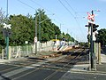
 The view north west from Platform 2 across to the Platform 1 building
6 October 2008 -
 The Platform 2 building from the car park
6 October 2008 -
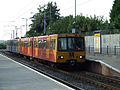
 The view south along Platform 2 as Metrocar No. 4048 is departing
6 October 2008 -
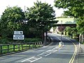
 The view north east along Station Road, across the level crossing
6 October 2008 -
 The view north west along Main Road, under the tracks
6 October 2008 -
 The view north west from Platform 2 across to Platform 1, to a train heading for South Hylton
6 October 2008 -
 The view south east from Platform 1 across to Platform 2
16 September 2009 -
 The view west along Platform 1, as a train bound for South Hylton approaches
16 September 2009 -
 The view west along Platform 2, across to Platform 1
2 January 2010 -
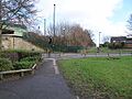 Looking east to where the Platform 2 footpath meets Main Road
1 February 2013 -
 The view south east along Main Road, under the tracks
3 August 2013


