Category:1690s maps of India
Jump to navigation
Jump to search
Countries of Asia: Afghanistan · Armenia‡ · Azerbaijan‡ · People's Republic of China · Cyprus‡ · Egypt‡ · Georgia‡ · India · Indonesia‡ · Iran · Iraq · Japan · Pakistan · Russia‡ · Syria · Turkey‡
Limited recognition: Taiwan · State of Palestine
‡: partly located in Asia
Limited recognition: Taiwan · State of Palestine
‡: partly located in Asia
Subcategories
This category has only the following subcategory.
Media in category "1690s maps of India"
The following 22 files are in this category, out of 22 total.
-

-
 Surrat City by William Hack.jpg 1,166 × 873; 176 KB
-
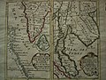
 Atlante Veneto Volume 2 108.jpg 10,575 × 7,116; 7.47 MB
-
 Atlante Veneto Volume 2 111.jpg 10,593 × 7,083; 7.9 MB
-
 AMH-2589-NA Ground plan of the fort at Cranganoor.jpg 2,400 × 1,841; 769 KB
-

-

-

-

-
-
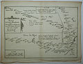 Du Val's more detailed route map of the Deccan, 1690, from Surat westward.jpg 1,600 × 1,236; 564 KB
-

-
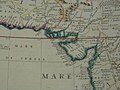
 Mouths of the Ganges.jpg 900 × 648; 148 KB
-

-

-

-

-
-

-

-

-


,_a_patron_of_Coronelli%27s_geographic_academy.jpg)


_to_Burhanpur_(here_shown_as_%22Brampore%22)_at_lower_right.jpg)


.jpg)