Category:Age of Discovery
Навигациягъа кёч
Излеуге кёч
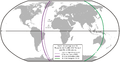
Период в истории человечества  Le planisphère de Cantino réalisé en 1502 est l'une des plus anciennes représentations des voyages de Christophe Colomb dans les Caraïbes, de Gaspar Corte-Real à Terre-Neuve, de Pedro Álvares Cabral au Brésil et de Vasco de Gama en Inde. | |||||
| Медиа-файл къошуу | |||||
| Произношение (звуковой файл) | |||||
|---|---|---|---|---|---|
| Это частный случай понятия |
| ||||
| Дата начала |
| ||||
| Дата окончания |
| ||||
| Предыдущее по порядку | |||||
| Следующее по порядку |
| ||||
| |||||
Тюбкатегорияла
18 тюбкатегориядан 18 киреди бу категориягъа.
A
C
D
F
G
M
P
Q
S
T
- Maximilianus Transylvanus (3 Ф)
- Treaty of Alcaçovas (6 Ф)
W
- William Weston (explorer) (3 Ф)
«Age of Discovery» категориядагъы файлла
Бу категорияда къуру бир файл барды.
-

-
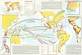
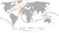
 16th century Portuguese Spanish trade routes.png 2835 × 1188; 2 МБ
-
 16th century Spanish trade routes.png 2835 × 1188; 775 КБ
-
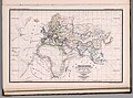
 Age of Discovery explorations in Arabic.png 1172 × 489; 446 КБ
-
 Age of Discovery explorations in English.png 1056 × 492; 484 КБ
-
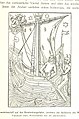
 An introduction to American history, European beginnings (1919) (14780285802).jpg 2816 × 1828; 1,16 МБ
-
 Discovery of America.jpg 1914 × 1504; 467 КБ
-
 Doncker sea atlas world map.jpg 760 × 575; 200 КБ
-
 Découvertes maritimes.jpg 2455 × 1297; 927 КБ
-
 Early voyagers, 1492.jpg 1902 × 1466; 1,03 МБ
-
 El hemisferio hispánico.jpg 3783 × 2566; 3,18 МБ
-
-
 Etat du Monde avant pendant la Decouverte des deux Indes, 1273 - 1519.jpg 4624 × 3437; 3,5 МБ
-
 European discoveries in the 15th, 16th and 17th centuries.jpg 2000 × 1444; 1,03 МБ
-
 Exploraciones español.png 1056 × 492; 486 КБ
-
 Exploraciones transatlánticas.png 3398 × 2616; 682 КБ
-
 Explos.png 1356 × 768; 73 КБ
-
-
 La expansión de los pueblos ibéricos.jpg 1793 × 2553; 1,67 МБ
-

-
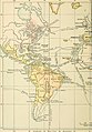
 McConnell's historical map, Early Grants.jpg 3299 × 2359; 1,51 МБ
-
 McConnell's historical map, Early Voyages and Discoveries.jpg 3289 × 2366; 1,53 МБ
-
 McConnell's historical map, English Explorations.jpg 3307 × 2393; 1,6 МБ
-
 McConnell's historical map, French Explorations.jpg 3304 × 2387; 1,46 МБ
-
 McConnell's historical map, National Claims.jpg 3302 × 2375; 1,42 МБ
-
 McConnell's historical map, Spanish Explorations.jpg 3306 × 2398; 1,42 МБ
-
 Mediaeval and modern history (1905) (14594635509).jpg 2005 × 2878; 691 КБ
-
 Ortogonalis polikonikus kepzetes kupvetulet.svg 1381 × 927; 2,91 МБ
-
 Planche VII - Découvertes du monde de 1400 a 1550 - liv3-ch10.png 4000 × 2968; 2 МБ
-
 Portuguese Black Ship Namban.jpg 1024 × 995; 311 КБ
-
 Portuguese Chapel Malindi niche.jpg 2480 × 2649; 1,36 МБ
-
 Quir Relatio Memorialis.pdf 2133 × 2910, 36 бет; 2,11 МБ
-
 Spain and Portugal-ar.png 1500 × 771; 225 КБ
-
 Spain and Portugal-fr.png 1500 × 771; 188 КБ
-
 Spain and Portugal.png 1500 × 771; 92 КБ
-
 SpanishPacific-es.svg 1250 × 1075; 4,1 МБ
-
 SpanishPacific.svg 1250 × 1075; 2,04 МБ
-
 Středověký trh.jpg 425 × 310; 57 КБ
-
 The Old World - Early explorers.jpg 1649 × 1366; 1,3 МБ
-
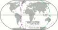
 The world at the Treaty of Saragossa, 1529.jpg 2933 × 1535; 1,17 МБ
-
 The World at the Treaty of Saragossa, 1529.jpg 2496 × 1642; 1,12 МБ
-
 The world, 1600-1650.jpg 2948 × 1508; 1,13 МБ
-
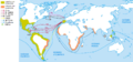
 Transatlantic explorations.png 3398 × 2616; 658 КБ
-
 Un nuevo continente, América.jpg 3783 × 2563; 3,2 МБ
-
 Vasco da Gama Pillar cross Malindi.jpg 1625 × 1413; 804 КБ
-
 Viajes de Colón y exploraciones simultáneas, 1492-1504.jpg 1388 × 1135; 331 КБ
-
 World 1340 1600.jpg 4593 × 2222; 1,49 МБ
-
 World, 1492 vs 1904.jpg 2454 × 895; 578 КБ
-
 Wpdms early grants 1621 1639.png 426 × 491; 87 КБ
-
 Zámořské cesty Portugalců a Španělů.jpg 1056 × 492; 270 КБ
-
 מפת חוזה סרגוסה.svg 1219 × 627; 643 КБ


_(14780285802).jpg)


,_etc%27_(11301019325).jpg)

,_H._G._Wells%27_Outline_of_History,_page_397.jpg)


_(14594635509).jpg)


