Category:Ancoats
Jump to navigation
Jump to search
inner city area of Manchester, in North West England | |||||
| Upload media | |||||
| Instance of | |||||
|---|---|---|---|---|---|
| Location | Manchester, Greater Manchester, North West England, England | ||||
 | |||||
English: situated in the Manchester City Council ward of Ancoats and Beswick
Subcategories
This category has the following 20 subcategories, out of 20 total.
A
- Church of All Souls, Manchester (10 F)
- Ancoats Hospital (11 F)
- Hallé St Peter's (4 F)
B
- Beehive Mill, Ancoats (2 F)
C
- Co-operative Press building (3 F)
E
- Every Street, Manchester (4 F)
G
- Gurney Street, Manchester (2 F)
H
- Hope Mill, Manchester (2 F)
J
- John Hetherington and Sons (4 F)
M
P
- Paragon Mill, Ancoats (8 F)
R
- Royal Mill, Manchester (7 F)
U
Media in category "Ancoats"
The following 144 files are in this category, out of 144 total.
-
 2-4 Swan Street, Ancoats.jpg 640 × 483; 186 KB
-
 44 new houses - geograph.org.uk - 4527170.jpg 1,000 × 742; 571 KB
-
 A former church on Every Street - geograph.org.uk - 3640145.jpg 800 × 600; 163 KB
-
 Amsterdam comes to Manchester - geograph.org.uk - 129482.jpg 640 × 421; 58 KB
-
 Ancoats - geograph.org.uk - 4134137.jpg 3,888 × 2,592; 1.9 MB
-
 Ancoats - geograph.org.uk - 4184347.jpg 2,347 × 2,018; 1.53 MB
-
 Ancoats - geograph.org.uk - 4184351.jpg 3,888 × 2,241; 1.71 MB
-
 Ancoats - geograph.org.uk - 4184363.jpg 2,592 × 3,426; 1.87 MB
-
 Ancoats - geograph.org.uk - 4625970.jpg 3,456 × 4,105; 1.66 MB
-
 Ancoats - geograph.org.uk - 4723708.jpg 4,529 × 3,098; 1.69 MB
-
 Ancoats - geograph.org.uk - 4901585.jpg 5,183 × 3,112; 1.95 MB
-
 Ancoats - geograph.org.uk - 5008850.jpg 4,516 × 2,637; 1.86 MB
-
 Ancoats - geograph.org.uk - 5008851.jpg 4,881 × 2,446; 1.59 MB
-
 Ancoats - geograph.org.uk - 5324309.jpg 3,456 × 3,637; 1.93 MB
-
 Ancoats - geograph.org.uk - 5351850.jpg 3,456 × 3,869; 1.56 MB
-
 Ancoats - geograph.org.uk - 5842592.jpg 4,936 × 2,713; 2 MB
-

-
 Ancoats Locks, Ashton Canal - geograph.org.uk - 2151.jpg 480 × 352; 33 KB
-
 Ancoats Mills - geograph.org.uk - 2643168.jpg 640 × 480; 73 KB
-
 Ancoats Primary Care Centre - geograph.org.uk - 3592733.jpg 640 × 532; 136 KB
-
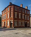
 Ancoats Works - geograph.org.uk - 3593251.jpg 922 × 1,280; 323 KB
-
 Ancoats, Manchester - geograph.org.uk - 3846212.jpg 1,728 × 3,072; 2.01 MB
-
 Ancoats, Marble Arch Inn - geograph.org.uk - 4293422.jpg 1,024 × 768; 142 KB
-
 Ancoats, Merrill Street - geograph.org.uk - 4340613.jpg 640 × 480; 254 KB
-
 Ancoats, ministries building - geograph.org.uk - 4293461.jpg 1,024 × 768; 134 KB
-
 Ancoats- 4477.JPG 3,488 × 2,616; 2.23 MB
-
 Ancoats- 4497.JPG 3,488 × 2,616; 2.19 MB
-
 Ancoats- Beehive4470.JPG 2,616 × 3,488; 2.11 MB
-
 Ancoats- Ice Plant 4498.JPG 3,488 × 2,616; 2.13 MB
-
 Ancoats- Murray Street 4491.JPG 3,488 × 2,616; 2.15 MB
-
 Ancoats- Sedgwick 4484.JPG 3,488 × 2,616; 2.09 MB
-
 Ancoats- St Peter's 4495.JPG 3,488 × 2,616; 2.15 MB
-
 Ancoats.jpg 1,000 × 789; 313 KB
-
 Anita Street, Ancoats - panoramio.jpg 3,072 × 2,304; 3.5 MB
-
 Anita Street, Ancoats, Manchester - geograph.org.uk - 2877138.jpg 3,648 × 2,736; 2.7 MB
-
 Ashtoncanal10.jpg 2,918 × 2,191; 2.5 MB
-
 Baines 1835-A&G Murray.png 711 × 487; 544 KB
-
 Bengal Street - geograph.org.uk - 5587592.jpg 4,462 × 2,992; 1.99 MB
-
 Bengal Street - geograph.org.uk - 5679344.jpg 1,280 × 2,021; 1.5 MB
-
 Bengal Street - geograph.org.uk - 5679640.jpg 1,280 × 960; 1.02 MB
-
 Blossom Street - geograph.org.uk - 5427024.jpg 1,000 × 840; 759 KB
-
 Brunswick Mill, Bradford Road, Manchester (geograph 2818450).jpg 610 × 640; 251 KB
-
 Canalside building, off Beswick Street - geograph.org.uk - 3985095.jpg 1,024 × 768; 148 KB
-
 Chips - geograph.org.uk - 3398497.jpg 2,475 × 3,809; 1.26 MB
-
 Chips - geograph.org.uk - 3398500.jpg 3,857 × 2,083; 1 MB
-
 Coates School 1821 - geograph.org.uk - 5678507.jpg 1,280 × 1,145; 972 KB
-
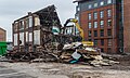
 Construction work on the site of the Smith Arms - geograph.org.uk - 5425417.jpg 1,000 × 930; 657 KB
-
 Cooperative Press, Manchester.jpg 1,024 × 757; 160 KB
-

-
 Cottonfield Wharf - geograph.org.uk - 5324336.jpg 3,193 × 2,920; 1.56 MB
-
 Cottonfield Wharf - geograph.org.uk - 5351874.jpg 5,184 × 2,920; 1.89 MB
-
 Cowan Street - geograph.org.uk - 5351819.jpg 4,895 × 3,023; 1.66 MB
-
 Cyrus Street - geograph.org.uk - 5351824.jpg 5,084 × 2,977; 1.9 MB
-
 Derelict Building, Ancoats - geograph.org.uk - 3234201.jpg 640 × 480; 581 KB
-
 Dereliction in Ancoats - geograph.org.uk - 2052541.jpg 1,280 × 856; 239 KB
-
 Derros Building, Ancoats.jpg 3,752 × 2,004; 1.73 MB
-

-
 Ducie Street, Ancoats-Manchester - geograph.org.uk - 3741452.jpg 640 × 480; 73 KB
-
 Edinburgh Castle - geograph.org.uk - 5425496.jpg 1,000 × 675; 491 KB
-
 Edinburgh Castle, Doorway - geograph.org.uk - 5425579.jpg 1,000 × 1,333; 1.29 MB
-
 Edinburgh Castle, Ghost sign - geograph.org.uk - 5425571.jpg 1,000 × 2,649; 2.13 MB
-
 Every Street, Ancoats - geograph.org.uk - 5441970.jpg 640 × 480; 69 KB
-
 Flats on Isaac Way - geograph.org.uk - 3640102.jpg 800 × 600; 160 KB
-
 Generation House - geograph.org.uk - 5679115.jpg 1,280 × 910; 857 KB
-
 George Leigh Street - geograph.org.uk - 4298153.jpg 3,842 × 2,368; 1.94 MB
-
 George Leigh Street - geograph.org.uk - 5427115.jpg 1,000 × 847; 640 KB
-
 George Leigh Street, Ancoats - geograph.org.uk - 784680.jpg 640 × 480; 107 KB
-
 Goulden Street - geograph.org.uk - 5842590.jpg 3,317 × 3,167; 2.01 MB
-
 Hallé St Peter's - geograph.org.uk - 4795366.jpg 1,000 × 679; 460 KB
-
 Hedgehog at Ancoats - geograph.org.uk - 4794288.jpg 1,000 × 1,000; 804 KB
-
 Inner City Living In Ancoats - geograph.org.uk - 838919.jpg 640 × 359; 61 KB
-
 Isaac Way - geograph.org.uk - 4134139.jpg 3,428 × 1,896; 1.81 MB
-
 Islington Wharf - geograph.org.uk - 3333569.jpg 2,592 × 3,888; 1.02 MB
-
 Jactin House - geograph.org.uk - 5679159.jpg 1,280 × 1,066; 869 KB
-
 Jersey Street - geograph.org.uk - 5029384.jpg 5,183 × 2,910; 1.9 MB
-
 Jersey Street - geograph.org.uk - 5679283.jpg 1,280 × 960; 926 KB
-
 Jolly Angler - geograph.org.uk - 4455285.jpg 2,736 × 2,936; 2.93 MB
-
 KitBag Logo RGB Black.png 2,228 × 1,029; 24 KB
-
 Little Ancoats Street - geograph.org.uk - 5064500.jpg 2,357 × 2,889; 1.76 MB
-
 Lockkeeper's Cottage on Ashton Canal in snow.jpg 2,792 × 1,365; 1.32 MB
-

-
 Manchester Girls' Institute c.1899 Exterior.jpg 1,748 × 2,529; 974 KB
-
 Manchester Girls' Institute, c.1899 Interior.jpg 2,454 × 1,592; 809 KB
-
 Mill on Laystall Street - geograph.org.uk - 1511486.jpg 640 × 430; 119 KB
-
 Murray Street - geograph.org.uk - 4795395.jpg 1,000 × 698; 541 KB
-
 Murray Street - geograph.org.uk - 5425245.jpg 1,000 × 758; 655 KB
-
 Murray Street - geograph.org.uk - 5679250.jpg 1,280 × 2,283; 1.79 MB
-
 Murray Street, Ancoats, Manchester - geograph.org.uk - 3347329.jpg 872 × 1,024; 145 KB
-

-
 Nothing stands still in 200 years at Ancoats - geograph.org.uk - 3985053.jpg 1,024 × 768; 102 KB
-
 Old Mill Street - Ancoats - geograph.org.uk - 3810617.jpg 4,029 × 3,185; 2.69 MB
-
 Paradise Walk Manchester.jpg 1,836 × 3,264; 1.61 MB
-
 PC World, Great Ancoat St - geograph.org.uk - 2203019.jpg 640 × 257; 56 KB
-
 Peak Street, Ancoats-Manchester - geograph.org.uk - 3741433.jpg 640 × 480; 104 KB
-
 Pollard St, Ancoats (7526619556).jpg 3,264 × 4,344; 2.72 MB
-
 Pollard St, Ancoats (7526620820).jpg 3,264 × 4,344; 2.51 MB
-
 Pollard St, Ancoats (7526621356).jpg 3,264 × 4,344; 2.69 MB
-
 Radium Street facing south - geograph.org.uk - 3600308.jpg 1,704 × 2,272; 1,005 KB
-
 Ragged School, Ancoats.jpg 1,024 × 746; 148 KB
-
 Reb's corner - geograph.org.uk - 5427036.jpg 1,000 × 916; 746 KB
-
 Residential development in Ancoats - geograph.org.uk - 2656900.jpg 640 × 475; 69 KB
-
 River Medlock- 4705.JPG 3,488 × 2,616; 2.19 MB
-
 Rochdale Canal - geograph.org.uk - 4134135.jpg 3,888 × 2,592; 1.9 MB
-
 Rochdale Canal at Butler Street, Ancoats - geograph.org.uk - 1185226.jpg 640 × 480; 166 KB
-
 Rodney Court - geograph.org.uk - 3371698.jpg 2,416 × 3,273; 1.49 MB
-
 Rodney Street Development - geograph.org.uk - 5351864.jpg 5,183 × 2,847; 1.91 MB
-
 Saima House - geograph.org.uk - 5427170.jpg 1,000 × 861; 575 KB
-
 Saltford Avenue - geograph.org.uk - 5064497.jpg 4,352 × 2,811; 1.84 MB
-
 Sankey's Mill - Chapeltown Street - geograph.org.uk - 2643188.jpg 640 × 480; 84 KB
-
 Sawmill Court construction - geograph.org.uk - 5679193.jpg 1,280 × 1,688; 1.45 MB
-
 Sedgwick Mill, Ancoats.jpg 640 × 480; 151 KB
-
 Serafino's Stone - geograph.org.uk - 5424363.jpg 1,000 × 931; 659 KB
-
 Serafino's Stone. - geograph.org.uk - 5424358.jpg 1,000 × 924; 659 KB
-
 Smith's Arms - geograph.org.uk - 4795512.jpg 1,000 × 711; 456 KB
-
 Smith's Arms - geograph.org.uk - 4795521.jpg 1,000 × 696; 488 KB
-
 Smith's Arms, Sherratt Street - geograph.org.uk - 4328899.jpg 4,320 × 3,240; 5.31 MB
-
 St Anne's - geograph.org.uk - 5351828.jpg 5,009 × 2,858; 1.5 MB
-
 St Peter's Church, Ancoats.jpg 3,572 × 2,513; 1.93 MB
-

-

-
 The (former) Mitchell Arms - geograph.org.uk - 4610326.jpg 1,000 × 1,000; 699 KB
-
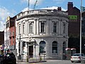
 The Bank of England, Ancoats - geograph.org.uk - 3224097.jpg 640 × 481; 492 KB
-
 The Mitchell Arms - geograph.org.uk - 1868217.jpg 800 × 600; 110 KB
-
 The Mitchell Arms - geograph.org.uk - 2058445.jpg 640 × 429; 108 KB
-
 The Mitchell Arms - geograph.org.uk - 3358254.jpg 640 × 461; 135 KB
-
 The Mitchell Arms - geograph.org.uk - 3358263.jpg 640 × 460; 162 KB
-
 The Mitchell Arms, 215 Every Street - geograph.org.uk - 2282003.jpg 1,024 × 751; 152 KB
-
 The Mitchells Arms' Lamp - geograph.org.uk - 3358274.jpg 640 × 640; 137 KB
-
 The River - geograph.org.uk - 3737182.jpg 3,613 × 2,292; 988 KB
-
 The River public house, Palmerston Street, Manchester - geograph.org.uk - 2877110.jpg 3,648 × 2,736; 2.32 MB
-
 The Rochdale Canal at Ancoats - geograph.org.uk - 4978639.jpg 3,632 × 4,998; 4.95 MB
-
 The Shamrock - geograph.org.uk - 5618633.jpg 640 × 482; 396 KB
-

-
 The Space, Great Ancoats Street, Manchester.jpg 4,320 × 3,240; 2.46 MB
-
 This was once Fulmer Drive, Ancoats - geograph.org.uk - 3983057.jpg 1,024 × 615; 122 KB
-
 Transforming Manchester Victoria Station - geograph.org.uk - 3630974.jpg 1,500 × 2,000; 705 KB
-
 Vesta Street - geograph.org.uk - 5571751.jpg 5,184 × 3,219; 2.05 MB
-
 Victoria Square, Ancoats.jpg 3,494 × 2,097; 1.98 MB
-
 Victoria Square, Manchester - geograph.org.uk - 3753419.jpg 3,710 × 2,998; 3.99 MB
-
 Warehouse on the Rochdale Canal - geograph.org.uk - 727039.jpg 640 × 427; 67 KB
-

-
 Welcome to Ancoats - geograph.org.uk - 5064505.jpg 4,352 × 2,123; 1.72 MB
-
 Wing Yip - geograph.org.uk - 5428164.jpg 1,000 × 1,037; 648 KB
-
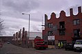
 Central Retail Park - geograph.org.uk - 1511763.jpg 640 × 480; 116 KB


.jpg)


.jpg)
.jpg)
.jpg)


,_Carruthers_Street_-_geograph.org.uk_-_2284020.jpg)
,_Carruthers_Street_-_geograph.org.uk_-_2284023.jpg)
_Mitchell_Arms_-_geograph.org.uk_-_4610326.jpg)


