Category:Ardgour
Jump to navigation
Jump to search
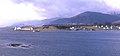
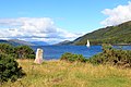
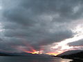
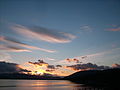
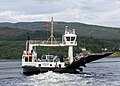
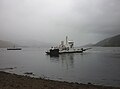
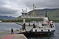
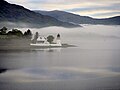
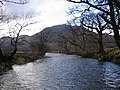
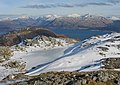
English: Ardgour (Scots Gaelic Ard ny Goair, meaning Height of the goats) is a village on the western shore of Loch Linnhe, on the Ardnamurchan peninisula, Lochaber, Highland, Scotland. Its pinewoods have been designated a Site of Special Scientific Interest.
Gaelg: Ta Ard ny Goair ( Baarle: Ardgour, Gaelg Albinagh: Ard Ghobhar) ny valley beg er çheu heear ny Lhingey Dhoo, er y lieh-innys Ardjyn Vuirchol, Logh Abar, Gaeltaght ny h-Albey.
human settlement in Highland, Scotland, UK  | |||||
| Upload media | |||||
| Instance of | |||||
|---|---|---|---|---|---|
| Location |
| ||||
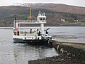
| Said to be the same as | Corran | ||||
 | |||||
Subcategories
This category has the following 5 subcategories, out of 5 total.
A
- Achaphubuil (18 F)
- Ardgour Church (6 F)
C
- Creach Bheinn (8 F)
G
- Garbh Bheinn (9 F)
S
- Sgùrr Dhòmhnuill (5 F)
Media in category "Ardgour"
The following 158 files are in this category, out of 158 total.
-

-
 A861 looking down Glen Tarbert - geograph.org.uk - 839254.jpg 640 × 480; 209 KB
-
 Acrocc the Corran Ferry - Flickr - Graham Grinner Lewis.jpg 3,648 × 2,736; 2.55 MB
-
 Adonia in the Corran Narrows (1) - geograph.org.uk - 4612872.jpg 1,250 × 857; 610 KB
-
 Adonia in the Corran Narrows (2) - geograph.org.uk - 4612874.jpg 1,250 × 825; 766 KB
-
 Ardgour - 1987 - geograph.org.uk - 2482561.jpg 2,272 × 1,515; 656 KB
-
 Ardgour - Flickr - Graham Grinner Lewis (1).jpg 3,648 × 2,736; 2.54 MB
-
 Ardgour - Flickr - Graham Grinner Lewis.jpg 3,648 × 2,736; 2.55 MB
-
-
 Ardgour Boat.jpg 2,045 × 1,521; 804 KB
-
 Ardgour Ferry, Lochaber, Scotland, Sept. 2010 - Flickr - PhillipC.jpg 3,825 × 2,384; 1.97 MB
-
 Ardgour fish farm - geograph.org.uk - 1771228.jpg 800 × 550; 103 KB
-
 Ardgour from the Corran Ferry - geograph.org.uk - 2165579.jpg 1,024 × 697; 162 KB
-
 Ardgour lighthouse, Scotland, 15 Sept. 2010 - Flickr - PhillipC.jpg 4,288 × 2,848; 2.17 MB
-
 Ardgour Memorial Hall - geograph.org.uk - 1703264.jpg 640 × 480; 68 KB
-
 Ardgour oak woods - geograph.org.uk - 3344777.jpg 640 × 480; 382 KB
-
 Ardgour Primary School - geograph.org.uk - 1703251.jpg 640 × 480; 104 KB
-
 Ardgour summit - geograph.org.uk - 1380007.jpg 640 × 480; 57 KB
-
 Ardgour's old road bypassed by the new - geograph.org.uk - 2281928.jpg 1,600 × 1,200; 678 KB
-
 Ardgour, The Inn - geograph.org.uk - 5470549.jpg 640 × 481; 482 KB
-
 Ardgour.jpg 640 × 299; 104 KB
-
 Awaiting the return - geograph.org.uk - 3996404.jpg 640 × 439; 39 KB
-
 Car being unloaded from the Corran Ferry at Ardgour - geograph.org.uk - 4323020.jpg 4,000 × 3,000; 2.97 MB
-
 Cill Mhaodain - geograph.org.uk - 13645.jpg 640 × 480; 172 KB
-
 Cill Mhaodain - geograph.org.uk - 13647.jpg 640 × 480; 144 KB
-
 Cill Mhaodain - geograph.org.uk - 52898.jpg 640 × 471; 194 KB
-
 Corran - geograph.org.uk - 5639855.jpg 1,600 × 1,042; 372 KB
-
 Corran Crossing - geograph.org.uk - 5905962.jpg 4,888 × 3,665; 3.5 MB
-
 Corran Ferry - geograph.org.uk - 4302120.jpg 1,600 × 1,297; 602 KB
-
 Corran Ferry - geograph.org.uk - 5639853.jpg 1,055 × 1,600; 354 KB
-
 Corran Ferry - geograph.org.uk - 6133640.jpg 1,600 × 1,060; 282 KB
-
 Corran Ferry Slipway, Nether Lochaber - geograph.org.uk - 5446743.jpg 640 × 481; 375 KB
-
 Corran Ferry, sheep in the road - geograph.org.uk - 921963.jpg 640 × 480; 117 KB
-
 Corran Lighthouse - geograph.org.uk - 4496922.jpg 640 × 480; 51 KB
-
 Corran lighthouse from the ferry - geograph.org.uk - 4440286.jpg 1,600 × 1,200; 332 KB
-
 Corran Loading - geograph.org.uk - 5904942.jpg 4,997 × 3,748; 3.37 MB
-
 Corran Narrows - 1987 - geograph.org.uk - 2482816.jpg 2,272 × 1,515; 507 KB
-
 Corran Narrows - geograph.org.uk - 5822977.jpg 1,024 × 743; 144 KB
-
 Corran Narrows Lighthouse - geograph.org.uk - 5639863.jpg 1,600 × 1,008; 284 KB
-

-

-
 Corran Shoal Marker Buoy, Loch Linnhe - geograph.org.uk - 5446763.jpg 640 × 480; 379 KB
-
 Fenceline, Garbh Bheinn - geograph.org.uk - 739181.jpg 640 × 480; 84 KB
-
 Ferry Approaching - geograph.org.uk - 5736140.jpg 640 × 425; 99 KB
-
 Ferry slipway by the Corran Narrows 1963 - geograph.org.uk - 2384518.jpg 2,544 × 1,618; 930 KB
-
 Flying Dutchman at Ardgour (1) - geograph.org.uk - 4612817.jpg 1,250 × 978; 745 KB
-
 Flying Dutchman at Ardgour (2) - geograph.org.uk - 4612826.jpg 896 × 1,250; 1.02 MB
-
 Fri Skien in the Corran Narrows (1) - geograph.org.uk - 4612870.jpg 1,250 × 748; 698 KB
-
 Fri Skien in the Corran Narrows (2) - geograph.org.uk - 4612871.jpg 1,250 × 738; 674 KB
-

-
 House building, Nether Lochaber - geograph.org.uk - 4363701.jpg 800 × 600; 463 KB
-
 House construction, Corran Narrows - geograph.org.uk - 3366272.jpg 640 × 389; 258 KB
-
 In the picture - geograph.org.uk - 3983703.jpg 640 × 380; 55 KB
-
 Into the mizzle - geograph.org.uk - 3996391.jpg 640 × 304; 22 KB
-
 Islay Trader in the Corran Narrows - geograph.org.uk - 4475254.jpg 1,024 × 732; 481 KB
-
 Leaving Ardgour - geograph.org.uk - 5450673.jpg 640 × 480; 71 KB
-
 Lighthouse and Ferry - geograph.org.uk - 5736286.jpg 425 × 640; 78 KB
-
 Lighthouse at Corran Narrows - geograph.org.uk - 5470556.jpg 640 × 480; 542 KB
-
 Lighthouse, Corran Point - geograph.org.uk - 5470547.jpg 640 × 481; 409 KB
-
 Linnhe Shoreline - geograph.org.uk - 5906071.jpg 5,184 × 3,888; 5 MB
-
 Loading the tour coach - Ardgour - geograph.org.uk - 4180658.jpg 1,250 × 936; 1 MB
-
 Loch Linnhe - geograph.org.uk - 2363631.jpg 640 × 480; 54 KB
-
 Loch Linnhe - geograph.org.uk - 2363640.jpg 640 × 480; 51 KB
-
 Loch Linnhe - geograph.org.uk - 2563064.jpg 3,456 × 2,304; 1,019 KB
-
 Loch Linnhe from An Camas Aiseig - geograph.org.uk - 3481880.jpg 2,931 × 1,944; 1.34 MB
-
 Loch Linnhe from Corran Point - geograph.org.uk - 3101866.jpg 3,456 × 2,304; 4.72 MB
-
 Loch Linnhe, Nether Lochaber - geograph.org.uk - 5446760.jpg 640 × 481; 410 KB
-
 Loch Linnhe, The Inn at Ardgour - geograph.org.uk - 5446751.jpg 640 × 481; 408 KB
-

-
 Lochaline road - geograph.org.uk - 894759.jpg 640 × 359; 74 KB
-
 MV Corran - geograph.org.uk - 4363711.jpg 800 × 599; 390 KB
-
 MV Isis in Loch Linnhe (1) - geograph.org.uk - 4436357.jpg 1,024 × 683; 498 KB
-
 MV Isis in Loch Linnhe (2) - geograph.org.uk - 4436359.jpg 1,024 × 669; 492 KB
-
-
 North Corran - geograph.org.uk - 5701365.jpg 1,024 × 683; 289 KB
-
 North Corran from the ferry - geograph.org.uk - 4900116.jpg 800 × 566; 116 KB
-
 North from the Corran Ferry - geograph.org.uk - 3983707.jpg 640 × 424; 97 KB
-
 Pier, Corran - geograph.org.uk - 3346311.jpg 640 × 480; 273 KB
-
 Rainwear essential - geograph.org.uk - 3996379.jpg 640 × 423; 115 KB
-
 River Tarbert - geograph.org.uk - 410329.jpg 640 × 480; 98 KB
-
 River Tarbert - geograph.org.uk - 410334.jpg 640 × 480; 98 KB
-
 Ronja Commander in the Corran Narrows - geograph.org.uk - 4475248.jpg 1,024 × 677; 485 KB
-
 Scotland lake sunset (Unsplash).jpg 5,472 × 3,648; 8.03 MB
-
 Seaborn Legend in the Corran Narrows - geograph.org.uk - 4180661.jpg 1,250 × 807; 745 KB
-
 Sheep in Ardgour - geograph.org.uk - 1261414.jpg 640 × 426; 116 KB
-
 Shoreline of Loch Linnhe at Ardgour - geograph.org.uk - 4429632.jpg 1,600 × 1,200; 388 KB
-
 Shoreline of Loch Linnhe at Corran Narrows - geograph.org.uk - 4440304.jpg 1,600 × 1,200; 485 KB
-
 Slipway, Corran Crossing - geograph.org.uk - 2363637.jpg 640 × 480; 44 KB
-
 Stob Coire a' Chearcaill - Flickr - Graham Grinner Lewis.jpg 3,648 × 2,736; 2.58 MB
-
 Summit cairn, Sgurr nan Cnamh - geograph.org.uk - 698013.jpg 640 × 480; 54 KB
-
 Sunset over Ardgour - panoramio - SteveMi (1).jpg 2,560 × 1,920; 2.1 MB
-
 Sunset over Ardgour - panoramio - SteveMi.jpg 2,560 × 1,920; 2.19 MB
-
 Sunset over Ardgour - panoramio.jpg 2,560 × 1,920; 2.2 MB
-
 The Ardgour Bar and Restaurant - geograph.org.uk - 1357858.jpg 640 × 480; 86 KB
-
 The Ardgour Hotel - geograph.org.uk - 5639867.jpg 1,600 × 969; 293 KB
-
 The Corran Ferry - geograph.org.uk - 3987046.jpg 640 × 424; 117 KB
-
 The Corran ferry - geograph.org.uk - 4180644.jpg 1,250 × 875; 940 KB
-
 The Corran Ferry - geograph.org.uk - 4615237.jpg 1,250 × 894; 943 KB
-
 The Corran Ferry - geograph.org.uk - 5114970.jpg 2,149 × 1,591; 1.25 MB
-
 The Corran ferry arriving in Ardgour - geograph.org.uk - 5574004.jpg 720 × 533; 60 KB
-

-
 The Corran ferry coming into Ardgour - geograph.org.uk - 5570064.jpg 640 × 480; 220 KB
-
 The Corran ferry en route to Ardgour - geograph.org.uk - 2445881.jpg 800 × 534; 156 KB
-
 The Corran Ferry leaves Nether Lochaber - geograph.org.uk - 5419092.jpg 5,472 × 3,648; 7.56 MB
-

-
 The Corran Narrows - geograph.org.uk - 5090230.jpg 1,200 × 1,600; 175 KB
-
 The Corran Narrows Lighthouse - geograph.org.uk - 5114977.jpg 3,086 × 1,922; 1.61 MB
-
 The Corran Narrows Lighthouse - geograph.org.uk - 5114983.jpg 3,238 × 2,110; 2.17 MB
-
 The Corran Point Lighthouse - geograph.org.uk - 4180666.jpg 1,250 × 838; 660 KB
-
 The ferry "Corran" at Corran - geograph.org.uk - 4058471.jpg 1,152 × 768; 443 KB
-
 The ferry Corran, at Corran Ferry - geograph.org.uk - 6191561.jpg 1,000 × 667; 626 KB
-
 The gorge in Gleann Mhic Phail - geograph.org.uk - 418497.jpg 640 × 480; 107 KB
-
 The Inn at Ardgour - geograph.org.uk - 1703477.jpg 640 × 480; 57 KB
-
 The Lighthouse at Corran Point - geograph.org.uk - 5446715.jpg 640 × 481; 317 KB
-
 The lower gorge of Gleann Mhic Phail - geograph.org.uk - 418500.jpg 640 × 480; 120 KB
-
-
 Track through Coille na Cuile - geograph.org.uk - 766693.jpg 640 × 427; 324 KB
-
 Track through Coille na Cuile, Ardgour - geograph.org.uk - 766707.jpg 427 × 640; 316 KB
-
 Track up Glen Gour - geograph.org.uk - 349461.jpg 640 × 480; 71 KB
-
 View of the Corran Ferry on the western shore - geograph.org.uk - 1917826.jpg 2,112 × 1,188; 436 KB
-
 Abhainn Coire an Iubhair. - geograph.org.uk - 139973.jpg 640 × 480; 143 KB
-
 Allt a' Chothruim - geograph.org.uk - 188717.jpg 480 × 640; 126 KB
-
 Bealach Mam a Bhearna - geograph.org.uk - 418491.jpg 640 × 480; 120 KB
-
 Beinn Bheag - geograph.org.uk - 139992.jpg 640 × 480; 39 KB
-
 Beinn Bheag - geograph.org.uk - 139997.jpg 640 × 373; 39 KB
-
 Beinn Bheag above Glen Gour. - geograph.org.uk - 5997.jpg 640 × 480; 60 KB
-
 Beinn na h-Uamha, East ridge - geograph.org.uk - 6004.jpg 640 × 457; 68 KB
-
 Beinn na-h-Uamha - geograph.org.uk - 6008.jpg 640 × 480; 83 KB
-
 Boulder, Coire an Iubhair - geograph.org.uk - 139970.jpg 640 × 480; 104 KB
-
 Boulder, Coire an Iubhair - geograph.org.uk - 139982.jpg 640 × 480; 147 KB
-
 Burn in Glen Gour - geograph.org.uk - 439545.jpg 480 × 640; 101 KB
-
 Coire an Iubhair - geograph.org.uk - 8477.jpg 640 × 480; 94 KB
-
 Coire an Iubhair - geograph.org.uk - 8478.jpg 640 × 480; 89 KB
-
 Coire an Iubhair - geograph.org.uk - 8479.jpg 640 × 480; 96 KB
-
 Coire an Iubhair. - geograph.org.uk - 139964.jpg 640 × 480; 84 KB
-
 Coire an Iubhair. - geograph.org.uk - 139968.jpg 640 × 480; 90 KB
-
 Creag an Fhir-eoin - geograph.org.uk - 5999.jpg 480 × 640; 112 KB
-
 Doire Driseach - geograph.org.uk - 753490.jpg 640 × 480; 131 KB
-
 Druim an Iubhair. - geograph.org.uk - 140340.jpg 640 × 480; 89 KB
-
 From Druim an Iubhair - geograph.org.uk - 140343.jpg 640 × 480; 95 KB
-
 Garbh Bheinn from Beinn Bheag - geograph.org.uk - 281542.jpg 640 × 211; 37 KB
-

-
 Garbh Coire Mor. - geograph.org.uk - 8480.jpg 502 × 640; 91 KB
-
 Granite boulders near Strontian - geograph.org.uk - 188698.jpg 640 × 480; 155 KB
-
 Lochan Coire an Iubhair. - geograph.org.uk - 139988.jpg 640 × 480; 81 KB
-
 Lochan Druim an Iubhair. - geograph.org.uk - 140342.jpg 640 × 480; 87 KB
-
 Meall a' Chuilinn - geograph.org.uk - 188715.jpg 480 × 640; 95 KB
-
 On Stob an Uilt Dharaich - geograph.org.uk - 6003.jpg 640 × 480; 84 KB
-
 Panorama from summit of Garbh Bheinn - geograph.org.uk - 281540.jpg 640 × 103; 22 KB
-
 River Gour - geograph.org.uk - 5995.jpg 640 × 480; 126 KB
-

-
 Scots Pine in Glen Gour - geograph.org.uk - 439566.jpg 640 × 480; 104 KB
-
 Sgorr Mhic Eacharna. - geograph.org.uk - 140000.jpg 640 × 456; 80 KB
-
 Summit of Sron a'Choire Bhig - geograph.org.uk - 8483.jpg 640 × 443; 79 KB
-

-
 The north ridge of Beinn Bheag - geograph.org.uk - 421192.jpg 640 × 480; 104 KB
-
 The south face of Beinn Na h-Uamha - geograph.org.uk - 421184.jpg 640 × 480; 109 KB
-


_-_geograph.org.uk_-_4612872.jpg)
_-_geograph.org.uk_-_4612874.jpg)

.jpg)


_-_geograph.org.uk_-_4612817.jpg)
_-_geograph.org.uk_-_4612826.jpg)
_-_geograph.org.uk_-_4612870.jpg)
_-_geograph.org.uk_-_4612871.jpg)


_-_geograph.org.uk_-_4436357.jpg)
_-_geograph.org.uk_-_4436359.jpg)


.jpg)


.jpg)


