Category:Barrier islands
Zur Navigation springen
Zur Suche springen
English: A Barrier island a coastal land form and a type of barrier system, are relatively narrow strips of sand that are parallel to the mainland coast. They usually occur in chains, consisting of anything from a few islands to more than a dozen.
eine durch Meeresarme vom Festland getrennte Küstendüne | |||||
| Medium hochladen | |||||
| Unterklasse von |
| ||||
|---|---|---|---|---|---|
| |||||
Unterkategorien
Es werden 12 von insgesamt 12 Unterkategorien in dieser Kategorie angezeigt:
In Klammern die Anzahl der enthaltenen Kategorien (K), Seiten (S), Dateien (D)
Medien in der Kategorie „Barrier islands“
Folgende 19 Dateien sind in dieser Kategorie, von 19 insgesamt.
-

-
 2010 Oil Slick Around Mississippi Barrier Islands.jpg 3.400 × 2.800; 3,35 MB
-
 2012-NL-prov-relief-3000.jpg 3.000 × 3.440; 2,91 MB
-
 Accreting coast Image6 rue.svg 1.355 × 640; 16 KB
-
 Accreting coast Image6.svg 1.481 × 697; 15 KB
-

-
 Barrier island (Tybee Island, Georgia, USA).jpg 3.008 × 1.323; 5,64 MB
-
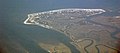
 Barrier Island along Arctic Shores.jpg 2.792 × 3.000; 4,11 MB
-
 Barrier Islands Erin (164)editcrop (16087852889).jpg 3.460 × 2.592; 5,75 MB
-
 Barrier Islands off Brazi.jpg 4.717 × 3.145; 3,94 MB
-

-
 Hatteras Island damage by Hurricane Isabel.jpg 3.054 × 2.048; 601 KB
-
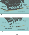 Isles Dernieres.gif 481 × 576; 23 KB
-

-
 Medlands Beach Great Barrier Island.jpg 1.600 × 1.200; 1,02 MB
-
 NCOuterBanks-EO.jpg 454 × 507; 54 KB
-
 NOAA- Outer Banks.jpg 403 × 464; 56 KB
-
 Tybee Island Light Station.jpg 1.003 × 766; 464 KB
-
 Tybee-island-lazaretto-ga1.jpg 1.917 × 1.101; 519 KB


.jpg)

editcrop_(16087852889).jpg)

.jpeg)


