Category:Beattock
Jump to navigation
Jump to search
village in Dumfries and Galloway, Scotland, UK   | |||||
| Upload media | |||||
| Instance of | |||||
|---|---|---|---|---|---|
| Location |
| ||||
 | |||||
English: The village of Beattock is located in the southern lowlands of Scotland, and lies within the council area of Dumfries and Galloway. It was an important stabling point for horses in the olden days with a coach house at one end of the village. It also boasts a bridge designed and built by Thomas Telford.
Subcategories
This category has the following 3 subcategories, out of 3 total.
Media in category "Beattock"
The following 52 files are in this category, out of 52 total.
-
 20210803 Sophie Grave Crew member.jpg 2,368 × 4,208; 4.16 MB
-
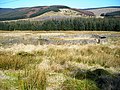
 Above Beattock - geograph.org.uk - 1007447.jpg 640 × 480; 73 KB
-
 Beattock bho shuas.jpg 960 × 730; 53 KB
-
 Beattock Hill - geograph.org.uk - 546018.jpg 640 × 480; 87 KB
-
 Beattock Hill - geograph.org.uk - 546022.jpg 640 × 480; 42 KB
-
 Beattock Hill - geograph.org.uk - 546028.jpg 640 × 480; 70 KB
-
 Beattock Signpost - geograph.org.uk - 1553214.jpg 640 × 480; 112 KB
-
 Beattock Summit - geograph.org.uk - 1691603.jpg 640 × 480; 123 KB
-
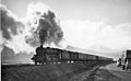
 Beattock Summit 2 geograph-2192109.jpg 900 × 579; 196 KB
-
 Beattock Summit 2060028 f41c4722.jpg 640 × 394; 110 KB
-
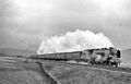
 Beattock Summit 3 geograph-2242384-by-Ben-Brooksbank.jpg 1,024 × 692; 284 KB
-
 Below Beattock Hill - geograph.org.uk - 634652.jpg 640 × 423; 55 KB
-

-
 Cottages south of Beattock - geograph.org.uk - 1005827.jpg 640 × 480; 72 KB
-
 Disused Pen Near Beattock Summit - geograph.org.uk - 375629.jpg 640 × 480; 209 KB
-
 Flower gardens at Moffat Woollen Mill - geograph.org.uk - 756764.jpg 640 × 480; 150 KB
-
 Going under the M71 (6742955503).jpg 3,648 × 2,736; 5.74 MB
-
 Je Ne Comprend Pas - geograph.org.uk - 129409.jpg 640 × 480; 168 KB
-
 Looking Ahead - geograph.org.uk - 1554782.jpg 640 × 480; 56 KB
-
 M74 - 1.jpg 2,989 × 1,964; 886 KB
-
 M74-2.jpg 2,728 × 1,342; 602 KB
-
 M74-3.jpg 2,884 × 2,002; 981 KB
-
 Memorial to 'Ben Wilson' - geograph.org.uk - 141620.jpg 480 × 640; 147 KB
-
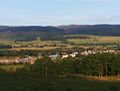
 Moffat and Beattock in the distance (6742913641).jpg 3,648 × 2,054; 3.01 MB
-
 Old Brig Inn, Beattock - geograph.org.uk - 1005821.jpg 640 × 480; 64 KB
-
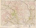
 Ordnance Survey One-Inch Sheet 16 Moffat, Published 1904.jpg 11,052 × 8,199; 14.39 MB
-
 Ordnance Survey One-Inch Sheet 84 Nithsdale & Moffatt, Published 1925.jpg 12,203 × 9,306; 14.87 MB
-
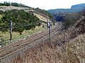 Railway Cutting Near Beattock Summit - geograph.org.uk - 375611.jpg 640 × 480; 223 KB
-

-
 Road to Beattock - geograph.org.uk - 498553.jpg 640 × 480; 153 KB
-

-
 Rth Beattock Sign 05.12 edited-2.jpg 1,031 × 750; 503 KB
-
 The Telford Bridge (6742939875).jpg 3,648 × 2,736; 5.72 MB
-
 Towards Peat Hill - geograph.org.uk - 185152.jpg 640 × 426; 140 KB
-
 Tree-line avenue south of Beattock - geograph.org.uk - 1005976.jpg 480 × 640; 115 KB
-
 VOSA Depot on M74 at Beattock1.jpg 1,955 × 1,337; 421 KB
-
 VOSA Depot on M74 at Beattock2.jpg 3,264 × 2,448; 1.17 MB
-
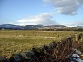 Another view towards Moffat. - geograph.org.uk - 141629.jpg 640 × 480; 113 KB
-

-
 Down from Annant Hill - geograph.org.uk - 195342.jpg 640 × 480; 75 KB
-
 Fence junction and firebreak - geograph.org.uk - 195349.jpg 640 × 480; 87 KB
-
 Looking Towards Barnhill Springs - geograph.org.uk - 127575.jpg 640 × 480; 146 KB
-
 Looking towards Moffat from Beattock Hill - geograph.org.uk - 141627.jpg 640 × 480; 104 KB
-
 Old wall and fire break - geograph.org.uk - 500968.jpg 640 × 480; 174 KB
-
 Peat Hill towards Craighoar - geograph.org.uk - 498543.jpg 640 × 480; 120 KB
-
 Pylons near Beattock - geograph.org.uk - 145251.jpg 640 × 480; 69 KB
-
 Railway Embankment South of Beattock - geograph.org.uk - 398770.jpg 640 × 480; 91 KB
-
 Road near Beattock - geograph.org.uk - 141626.jpg 640 × 480; 133 KB
-

-
 Track to Lochanhead - geograph.org.uk - 185157.jpg 640 × 426; 124 KB
-

-


.jpg)


.jpg)


.jpg)


