Category:Blackinton, Massachusetts
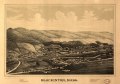
Blackinton, Massachusetts grew up around the mills of the Blackinton Company, founded on the north bank of the Hoosic River in 1821 by Sanford Blackinton, Rufus Wells and J.L White. It would became one of the largest manufacturers of woolen goods in Western Massachusetts. By the early 1900s the neighborhood was a self-contained community, with its own school, jail, stores, post office, library and fire department, and the people there considered themselves be residents of "Blackinton", not North Adams. The community – which historically had been disputed between North Adams and Williamstown – had a station on the Boston & Maine, as well as bus service to North Adams. The mill closed in 1950. (Source: Oehler, Kay; Sheppard, Stephen C.; Benjamin, Blair and Li, Lily. "Shifting Sands in Changing Communities: The Neighborhoods, Social Services, and Cultural Organizations of North Adams, Massachusetts" and "Sanford Blackinton")
| Object location | | View all coordinates using: OpenStreetMap |
|---|
historic district in North Adams, Massachusetts  | |||||
| Upload media | |||||
| Instance of | |||||
|---|---|---|---|---|---|
| Location | North Adams, Berkshire County, Massachusetts | ||||
| Heritage designation |
| ||||
 | |||||
Subcategories
This category has the following 2 subcategories, out of 2 total.
Media in category "Blackinton, Massachusetts"
The following 8 files are in this category, out of 8 total.
-
 Blackinton Union Church Massachusetts Avenue Blackinton North Adams.jpg 1,677 × 1,605; 599 KB
-
 Blackinton Union Church, Blackinton MA.jpg 2,272 × 1,704; 1.11 MB
-
 Blackinton, Mass. (2673694603).jpg 2,000 × 1,459; 2.02 MB
-
 Blackinton, Mass. LOC 83693956.jpg 7,328 × 5,168; 7.27 MB
-
 Blackinton, Mass. LOC 83693956.tif 7,328 × 5,168; 108.35 MB
-
 Eber Sherman Farm, North Adams MA.jpg 2,272 × 1,704; 1.29 MB
-
 Minerva Arts Center 1288 Massachusetts Avenue Blackinton North Adams.jpg 1,606 × 2,250; 751 KB
-
 West view of Blackinton Company, Blackinton MA.jpg 2,272 × 1,704; 1.51 MB


.jpg)


