Category:Blairgowrie and Rattray
Zur Navigation springen
Zur Suche springen

English: Blairgowrie and Rattray (Blàr Ghobharaidh and Raitear in Gaelic, Blairgowrie - likely Scottish Gaelic Blàr Ghobharaidh and Rattray - possibly from an English language cognate of Scottish Gaelic ràth, meaning fortress + a Pictish term cognate with Welsh tref, meaning settlement) is a burgh in Perth and Kinross, Scotland. Amongst locals, the town is colloquially known simply as "Blair".
Gàidhlig: 'S e baile ann am Peairt agus Ceann Rois a th' ann am Blàr Ghobharaidh (Beurla: Blairgowrie). 'S e seo na co-chomharran aige: 56° 35′ 31.27″ Tuath agus 3° 20′ 24.49″ Iar.
Ortschaft im Vereinigten Königreich  | |||||
| Medium hochladen | |||||
| Ist ein(e) |
| ||||
|---|---|---|---|---|---|
| Ort |
| ||||
| Besteht aus | |||||
 | |||||
Unterkategorien
Es werden 6 von insgesamt 6 Unterkategorien in dieser Kategorie angezeigt:
In Klammern die Anzahl der enthaltenen Kategorien (K), Seiten (S), Dateien (D)
Medien in der Kategorie „Blairgowrie and Rattray“
Folgende 57 Dateien sind in dieser Kategorie, von 57 insgesamt.
-
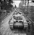 Allied Forces in the United Kingdom 1939-45 H16100.jpg 789 × 800; 107 KB
-

-
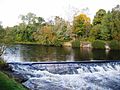 Amhainn Ericht.jpg 448 × 336; 42 KB
-
 Blairgowrie (2498234205).jpg 2.043 × 1.529; 2,73 MB
-

-

-

-
 Blairgowrie caravan park - geograph.org.uk - 684572.jpg 602 × 400; 89 KB
-
 Blairgowrie High School.png 146 × 96; 11 KB
-
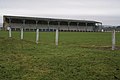 Blairgowrie JFC - geograph.org.uk - 684688.jpg 640 × 426; 59 KB
-
 Blairgowrie Rattray banner.jpg 2.100 × 299; 255 KB
-
 Blairgowrie-rattray.jpg 2.500 × 608; 487 KB
-
 Cateran Trail above Blairgowrie - geograph.org.uk - 1533438.jpg 640 × 480; 199 KB
-
 Cattle above Blairgowrie - geograph.org.uk - 1533388.jpg 640 × 480; 173 KB
-

-
 Davie Park boating pond. Now home to ducks and nothing more. - panoramio.jpg 2.592 × 1.936; 2,65 MB
-

-
 Davie Park boating pond. Plus ducks. - panoramio.jpg 2.592 × 1.936; 2,43 MB
-
 Direction indicator above Blairgowrie - geograph.org.uk - 1533506.jpg 640 × 480; 170 KB
-
 Donald Cargill Monument - geograph.org.uk - 1400961.jpg 640 × 480; 138 KB
-
 Farming country. Road signs murdered by air rifles - panoramio.jpg 2.592 × 1.936; 2,46 MB
-

-
 Ferguson Park - geograph.org.uk - 684659.jpg 640 × 426; 86 KB
-
 Footpath to Blairgowrie - geograph.org.uk - 1533469.jpg 640 × 482; 208 KB
-
 Highlanders - geograph.org.uk - 329935.jpg 426 × 640; 68 KB
-
 Kinloch House Hotel - geograph.org.uk - 139984.jpg 640 × 480; 58 KB
-
 Kinpurnie from Blairgowrie - geograph.org.uk - 894569.jpg 640 × 480; 56 KB
-
 Marfield public house - geograph.org.uk - 684602.jpg 640 × 426; 78 KB
-
 Old railway to Blairgowrie - geograph.org.uk - 350828.jpg 640 × 480; 76 KB
-
 Ordnance Survey One-Inch Sheet 49 Blairgowrie, Published 1958 2.jpg 8.610 × 10.668; 19,76 MB
-
 Ordnance Survey One-Inch Sheet 49 Blairgowrie, Published 1958.jpg 8.241 × 9.880; 11,46 MB
-
 P1000424 Bridge over Ericht in Blairgowrie.jpg 1.024 × 768; 241 KB
-
 P1000438 strawberry fields.jpg 1.024 × 768; 104 KB
-
 Poplar trees, Blairgowrie - geograph.org.uk - 1533543.jpg 640 × 480; 179 KB
-
 River Ericht - Blairgowrie.jpg 3.264 × 2.448; 2,42 MB
-
 River Ericht - geograph.org.uk - 687563.jpg 640 × 426; 75 KB
-
 River Ericht - geograph.org.uk - 909532.jpg 640 × 360; 130 KB
-
 River Ericht at Blairgowrie - geograph.org.uk - 1324864.jpg 640 × 427; 119 KB
-
 River Ericht at Blairgowrie - geograph.org.uk - 409891.jpg 640 × 480; 134 KB
-
 River Ericht at Blairgowrie - geograph.org.uk - 409959.jpg 640 × 480; 91 KB
-
 River Ericht Blairgowrie - geograph.org.uk - 79633.jpg 480 × 640; 128 KB
-
 River Ericht near Blairgowrie - geograph.org.uk - 1532987.jpg 640 × 480; 182 KB
-
 River Ericht, Blairgowrie - geograph.org.uk - 338577.jpg 600 × 440; 117 KB
-

-
 Rough grazing above Blairgowrie - geograph.org.uk - 1533332.jpg 640 × 480; 129 KB
-
 Scrapyard, Blairgowrie - geograph.org.uk - 703785.jpg 640 × 480; 116 KB
-
 Steps, Blairgowrie - geograph.org.uk - 1532977.jpg 640 × 480; 202 KB
-
 Tesco - Blairgowrie - geograph.org.uk - 1721435.jpg 640 × 480; 83 KB
-
 Tesco, Blairgowrie - geograph.org.uk - 1099992.jpg 640 × 480; 58 KB
-
 The Balmoral - geograph.org.uk - 909567.jpg 640 × 480; 72 KB
-
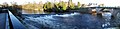
 The River Ericht - geograph.org.uk - 409935.jpg 640 × 480; 115 KB
-
 The River Ericht at Blairgowrie - geograph.org.uk - 1632234.jpg 427 × 640; 70 KB
-
 View of Blairgowrie Bridge - geograph.org.uk - 1324823.jpg 640 × 427; 75 KB
-

-
 Westfields of Rattray - geograph.org.uk - 650826.jpg 640 × 426; 86 KB
-
 Cattle above Blairgowrie - geograph.org.uk - 211288.jpg 640 × 497; 52 KB
-
 Fruit production - geograph.org.uk - 488888.jpg 640 × 425; 105 KB


.jpg)


_on_the_Ericht_at_Blairgowrie_-_geograph.org.uk_-_1565763.jpg)


