Category:Bomhus kyrka
Jump to navigation
Jump to search
| Object location | | View all coordinates using: OpenStreetMap |
|---|
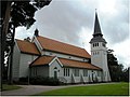
church building in Gävle Municipality, Sweden   | |||||
| Upload media | |||||
| Instance of | |||||
|---|---|---|---|---|---|
| Location | Gävle Municipality, Gävleborg County, Sweden | ||||
| Diocese | |||||
| Connects with | |||||
| Has use |
| ||||
| Occupant |
| ||||
| Heritage designation |
| ||||
| Date of official opening |
| ||||
 | |||||
Svenska: Bomhus kyrka tillhör Gävle församling, Gästriklands kontrakt, Uppsala stift / Diocese of Uppsala.
|
This is a category about an ecclesiastical monument in Sweden, number 21300000020394 (sub-number: 21400000616756) in the RAÄ buildings database.
|
Subcategories
This category has the following 2 subcategories, out of 2 total.
B
- Bomhus kyrkogård (1 F)
I
- Interior of Bomhus kyrka (2 F)
Media in category "Bomhus kyrka"
The following 8 files are in this category, out of 8 total.
-
 Bomhus kyrka - KMB - 16000200031047.jpg 439 × 600; 58 KB
-
 Bomhus kyrka - KMB - 16000200031049.jpg 783 × 600; 142 KB
-
 Bomhus kyrka - KMB - 16000200031052.jpg 794 × 600; 100 KB
-
 Bomhus kyrka - KMB - 16000200031053.jpg 791 × 600; 89 KB
-
 Bomhus kyrka old1.jpg 396 × 600; 58 KB
-
 Bomhus kyrka old2.jpg 450 × 600; 63 KB
-
 Bomhuskyrka21500001410603.jpg 1,022 × 769; 91 KB
-
 Bomhuskyrka21500001410607.png 1,502 × 1,130; 2.12 MB


