Category:Brewood
Jump to navigation
Jump to search
village in Staffordshire, England, United Kingdom  | |||||
| Upload media | |||||
| Instance of | |||||
|---|---|---|---|---|---|
| Location | Brewood and Coven, South Staffordshire, Staffordshire, West Midlands, England | ||||
 | |||||
Subcategories
This category has the following 5 subcategories, out of 5 total.
Media in category "Brewood"
The following 192 files are in this category, out of 192 total.
-
 'Keepers Cottage' - geograph.org.uk - 737576.jpg 640 × 480; 79 KB
-
 'The Cottage' - geograph.org.uk - 276740.jpg 600 × 450; 226 KB
-
 2 School Road, Brewood.jpg 1,400 × 2,097; 850 KB
-

-
 A tight squeeze on the Shropshire Union - geograph.org.uk - 597458.jpg 640 × 480; 252 KB
-

-
 Autumn on the Lower Avenue - geograph.org.uk - 597428.jpg 450 × 600; 370 KB
-

-
 Bargate Street, Brewood - geograph.org.uk - 2484311.jpg 640 × 428; 64 KB
-
 Black Ladies 1846.jpg 884 × 717; 187 KB
-
 (Im)mobile homes - geograph.org.uk - 737512.jpg 640 × 480; 70 KB
-
 Brewood - Market Pl - geograph.org.uk - 5233235.jpg 5,184 × 2,920; 5.19 MB
-
 Brewood - Speedwell Castle - geograph.org.uk - 5233240.jpg 5,184 × 2,920; 5.09 MB
-

-

-
-

-
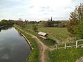
 Brewood canal north.JPG 2,736 × 3,648; 4.32 MB
-
 Brewood canal south.JPG 3,648 × 2,736; 4.46 MB
-
 Brewood Cricket Club - geograph.org.uk - 392559.jpg 640 × 480; 102 KB
-
 Brewood fire station - geograph.org.uk - 607275.jpg 640 × 427; 209 KB
-
 Brewood Fire Station.jpg 3,568 × 2,368; 7.13 MB
-
 Brewood Garage - geograph.org.uk - 1603574.jpg 640 × 480; 78 KB
-
 Brewood Market Place 01.JPG 2,721 × 2,922; 1.2 MB
-
 Brewood Police Station - geograph.org.uk - 1805230.jpg 3,296 × 2,472; 1.82 MB
-
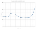
 Brewood Pop.svg 748 × 503; 67 KB
-
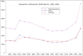
 Brewood Population 1801-1961.png 1,132 × 919; 41 KB
-
 Brewood Thomas Anrew Walker birthplace.JPG 3,648 × 2,736; 2.94 MB
-
 Brewood through the trees - geograph.org.uk - 4731466.jpg 480 × 640; 121 KB
-
 Brewood Towpath - geograph.org.uk - 4456275.jpg 800 × 600; 96 KB
-
 Brewood View - geograph.org.uk - 1600898.jpg 480 × 640; 97 KB
-
 Brewood View - geograph.org.uk - 1603471.jpg 640 × 480; 76 KB
-
 Brewood Village (Pronounced brood) - geograph.org.uk - 23771.jpg 640 × 424; 27 KB
-

-
 Brewood Wesleyan chapel.JPG 3,648 × 2,736; 2.06 MB
-
 Brewood, Jubilee Hall - geograph.org.uk - 3728723.jpg 1,024 × 768; 180 KB
-
 Brewood, Speedwell Castle - geograph.org.uk - 3728665.jpg 1,024 × 768; 139 KB
-
 Brewood, Swan Hotel - geograph.org.uk - 3728706.jpg 1,024 × 768; 122 KB
-
 Bridge Inn - geograph.org.uk - 622017.jpg 640 × 480; 52 KB
-

-

-
 Bridge No 10, The Avenue Bridge - geograph.org.uk - 597447.jpg 640 × 480; 319 KB
-
 Bridge No 9, Chillington Bridge - geograph.org.uk - 597410.jpg 640 × 480; 329 KB
-
 Bridge No. 15, Shropshire Union Canal.jpg 1,600 × 900; 1.74 MB
-
 Bridge No. 5, Shropshire Union Canal.jpg 800 × 617; 161 KB
-
 Bridge No. 6, Shropshire Union Canal.jpg 800 × 600; 191 KB
-
 Bridge No. 7, Shropshire Union Canal.jpg 800 × 537; 161 KB
-
 Bridge No. 8, Shropshire Union Canal.jpg 800 × 569; 174 KB
-
 Bridge over the River Penk - geograph.org.uk - 311152.jpg 600 × 450; 284 KB
-

-
 Broom Hall approached from the canal - geograph.org.uk - 737519.jpg 640 × 480; 74 KB
-
 Broomhall Bridge - geograph.org.uk - 622027.jpg 640 × 480; 95 KB
-
 Bullocks - Across the River Penk - geograph.org.uk - 1444438.jpg 640 × 480; 302 KB
-
 Can't see the wood for the trees - geograph.org.uk - 737549.jpg 640 × 480; 117 KB
-
 Canal Milepost, Brewood.jpg 640 × 480; 100 KB
-
 Canal View - geograph.org.uk - 648312.jpg 640 × 480; 63 KB
-
-
 Chillington Farm - geograph.org.uk - 737544.jpg 640 × 480; 77 KB
-
 Chillington Junction - geograph.org.uk - 649181.jpg 640 × 480; 81 KB
-
 Chillington Street - geograph.org.uk - 1601269.jpg 640 × 480; 90 KB
-
 Chillington View - geograph.org.uk - 649222.jpg 640 × 480; 67 KB
-
 Codsall to Brewood road - geograph.org.uk - 665967.jpg 640 × 479; 128 KB
-
 Contented longhorns on 'The Avenue' - geograph.org.uk - 597502.jpg 640 × 480; 358 KB
-
 Convenient place for a rest - geograph.org.uk - 737610.jpg 640 × 480; 64 KB
-
-
-
 Damaged Barrier - geograph.org.uk - 311154.jpg 600 × 450; 288 KB
-
 Dean House, Brewood.jpg 768 × 1,024; 240 KB
-
 Dean Street - geograph.org.uk - 1603522.jpg 480 × 640; 50 KB
-
 Dean's Hall Pool - geograph.org.uk - 1603490.jpg 640 × 480; 87 KB
-

-
 Engleton Lane, Brewood, Staffordshire - geograph.org.uk - 1085173.jpg 640 × 483; 125 KB
-

-
-
 Entrance to Brewood Playing Field - geograph.org.uk - 5193978.jpg 6,000 × 4,000; 4.73 MB
-
 Eskew Bridge - geograph.org.uk - 622032.jpg 640 × 480; 60 KB
-
 Farmland north of Brewood, Staffordshire - geograph.org.uk - 1374978.jpg 640 × 480; 130 KB
-
 Follow the track to Chillington Farm - geograph.org.uk - 737535.jpg 640 × 480; 69 KB
-
 Footpath across the field towards Brewood - geograph.org.uk - 737584.jpg 640 × 480; 116 KB
-
 Footpath near River Penk - geograph.org.uk - 201051.jpg 640 × 480; 80 KB
-
 Footpath to Brewood - geograph.org.uk - 147523.jpg 640 × 480; 162 KB
-
 Footpath to Brewood - geograph.org.uk - 737603.jpg 640 × 480; 57 KB
-

-

-
 Giffard's Cross Bridge - geograph.org.uk - 277262.jpg 600 × 450; 284 KB
-
 Giffard's Cross, near Chillington Hall - geograph.org.uk - 276718.jpg 450 × 600; 305 KB
-
 Giffards Cross and Lodge.JPG 3,648 × 2,736; 2.57 MB
-
 Giffards Cross Bridge near Brewood in Staffordshire (geograph 5813327).jpg 960 × 1,280; 1.84 MB
-
 Grazing land near Brewood, Staffordshire - geograph.org.uk - 1373039.jpg 640 × 441; 120 KB
-
 Heron near Park Bridge - geograph.org.uk - 517597.jpg 640 × 428; 129 KB
-
 Horse Paddock Wood - geograph.org.uk - 788045.jpg 640 × 480; 104 KB
-
 Hunting Bridge - geograph.org.uk - 648314.jpg 640 × 480; 56 KB
-
 Keep Out - geograph.org.uk - 311163.jpg 500 × 383; 241 KB
-
 Lower Avenue Path - geograph.org.uk - 648306.jpg 640 × 480; 135 KB
-
 Lower Avenue View - geograph.org.uk - 1600905.jpg 480 × 640; 173 KB
-
 Milepost at NGR SJ 874 104.jpg 800 × 772; 295 KB
-
 Milepost at NGR SJ 891 060.jpg 800 × 665; 262 KB
-
 Milepost north of Brewood Bridge.jpg 800 × 745; 224 KB
-
 Monarch's Way - geograph.org.uk - 788009.jpg 640 × 480; 94 KB
-
 Moored for while - geograph.org.uk - 737615.jpg 640 × 480; 95 KB
-

-

-
 No 8 Bridge - geograph.org.uk - 648313.jpg 640 × 480; 81 KB
-
 Old Smithy Cottage, Brewood.jpg 1,024 × 768; 220 KB
-
 OS benchmark - Brewood, 5a Stafford Street - geograph.org.uk - 4327103.jpg 857 × 1,142; 465 KB
-

-

-
-
 OS benchmark - Brewood, Shop Lane corner - geograph.org.uk - 4328724.jpg 857 × 1,142; 546 KB
-
 OS benchmark - Brewood, Stone House - geograph.org.uk - 4325960.jpg 857 × 1,142; 440 KB
-
 Park Bridge, Shropshire Union Canal - geograph.org.uk - 517601.jpg 640 × 428; 118 KB
-
 River Penk - geograph.org.uk - 311142.jpg 550 × 412; 195 KB
-
 River Penk - geograph.org.uk - 311161.jpg 600 × 450; 259 KB
-
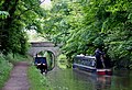
 Shropshire Union Canal - geograph.org.uk - 276589.jpg 600 × 450; 316 KB
-
 Shropshire Union Canal - geograph.org.uk - 277266.jpg 375 × 500; 186 KB
-
 Shropshire Union Canal - geograph.org.uk - 282540.jpg 640 × 480; 98 KB
-
-
 Shropshire Union Canal at Brewood, Staffordshire - geograph.org.uk - 1372950.jpg 1,024 × 1,024; 680 KB
-

-

-
 Shropshire Union Canal bridge No 12 - geograph.org.uk - 737605.jpg 640 × 480; 88 KB
-

-

-

-
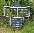
 Shropshire Union Canal Milepost - geograph.org.uk - 282544.jpg 640 × 480; 167 KB
-
 Sparrows End Lane, Brewood - geograph.org.uk - 1805190.jpg 3,296 × 2,472; 1.91 MB
-
 Speedwell Castle, Brewood - geograph.org.uk - 1805217.jpg 2,472 × 3,296; 1.92 MB
-
 Stafford Street, Brewood.jpg 1,280 × 960; 1.08 MB
-
 Staffordshire Way Sheep - geograph.org.uk - 1603234.jpg 640 × 480; 122 KB
-
 Staffs Way Stile - geograph.org.uk - 1603228.jpg 640 × 480; 112 KB
-
 Steps to the pub - geograph.org.uk - 737622.jpg 640 × 480; 110 KB
-
 Stretton Bridge over River Penk - geograph.org.uk - 1443937.jpg 640 × 480; 322 KB
-
 The Bell Inn on Watling Street - geograph.org.uk - 857172.jpg 640 × 480; 61 KB
-
 The Bridge Inn Pub, Brewood - geograph.org.uk - 1951182.jpg 2,048 × 1,536; 640 KB
-
 The Bridge Inn, Brewood - geograph.org.uk - 1805278.jpg 3,296 × 2,472; 1.84 MB
-
 The Lion Hotel, Brewood - geograph.org.uk - 1805265.jpg 3,296 × 2,472; 1.91 MB
-
 The Old House, Sandy Lane, Brewood - geograph.org.uk - 1805197.jpg 3,296 × 2,472; 1.84 MB
-
 The Shropshire Union Canal at Brewood - geograph.org.uk - 1805272.jpg 2,472 × 3,296; 2.33 MB
-
-
 The Shropshire Union Canal, Brewood - geograph.org.uk - 1805283.jpg 3,296 × 2,472; 1.91 MB
-
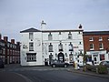
 The Swan Hotel, Brewood - geograph.org.uk - 1805226.jpg 3,296 × 2,472; 1.85 MB
-
 The White House - geograph.org.uk - 311135.jpg 640 × 480; 290 KB
-
 The White House, Somerford Lane, near Brewood - geograph.org.uk - 1805187.jpg 3,296 × 2,472; 1.8 MB
-
 The Woolley Farm - geograph.org.uk - 1603419.jpg 640 × 480; 81 KB
-
 This is supposed to be a Bridleway - geograph.org.uk - 737523.jpg 640 × 480; 67 KB
-
 Track to 'The Whitemoor' - geograph.org.uk - 737541.jpg 640 × 480; 60 KB
-
 Track to Hyde Farm - geograph.org.uk - 737595.jpg 640 × 480; 74 KB
-
 Track to some cottages - geograph.org.uk - 737564.jpg 640 × 480; 103 KB
-

-
 Upper Avenue Lane - geograph.org.uk - 649185.jpg 640 × 480; 72 KB
-
 Waterworks and Trees - geograph.org.uk - 147519.jpg 640 × 480; 154 KB
-

-
 Watling Street north-west of Brewood, Staffordshire - geograph.org.uk - 4768860.jpg 1,024 × 1,024; 1,004 KB
-
 Westgate, Brewood.jpg 768 × 1,024; 259 KB
-

-
 Winter fields north of Brewood - geograph.org.uk - 4321652.jpg 1,142 × 857; 472 KB
-
 Wooley Pools - geograph.org.uk - 1603400.jpg 640 × 480; 134 KB
-
 Working Narrow Boat Hadar moored at Brewood - geograph.org.uk - 3079792.jpg 3,648 × 2,736; 4.09 MB
-
 Big lorry on a small bridge - geograph.org.uk - 277253.jpg 500 × 375; 200 KB
-
 Brewood Bridge - geograph.org.uk - 622050.jpg 640 × 480; 50 KB
-
 Brewood Village. - geograph.org.uk - 23772.jpg 640 × 422; 17 KB
-
 Brewood Wharf - geograph.org.uk - 517613.jpg 640 × 428; 118 KB
-
 Brick Kiln Lane - geograph.org.uk - 277032.jpg 500 × 375; 220 KB
-
 Bridge over River Penk - geograph.org.uk - 200143.jpg 640 × 480; 145 KB
-
 Coppice Edge - geograph.org.uk - 649174.jpg 640 × 480; 73 KB
-
 Engleton Hall - geograph.org.uk - 248483.jpg 640 × 480; 65 KB
-
 Farm at Road Junction near Brewood - geograph.org.uk - 322418.jpg 600 × 450; 228 KB
-
 Farm buildings - geograph.org.uk - 322408.jpg 600 × 450; 214 KB
-
 Farm buildings with weathervane - geograph.org.uk - 322396.jpg 450 × 600; 245 KB
-
 Farm Cottage - geograph.org.uk - 322391.jpg 600 × 450; 210 KB
-
 Farmhouse for sale - geograph.org.uk - 322405.jpg 600 × 450; 301 KB
-
 Footbridge over River Penk - geograph.org.uk - 311120.jpg 550 × 412; 266 KB
-
 Footbridge over the Mill Race - geograph.org.uk - 311113.jpg 600 × 450; 278 KB
-
 Footbridges at Somerford Mill - geograph.org.uk - 311117.jpg 550 × 412; 183 KB
-
 Footpath to Crateford - geograph.org.uk - 311129.jpg 550 × 412; 271 KB
-
 From River Penk Bridge Looking SW - geograph.org.uk - 201048.jpg 640 × 480; 104 KB
-
 Horsebrook Farm - geograph.org.uk - 248487.jpg 640 × 480; 97 KB
-
 Kissing gate on the Staffordshire Way - geograph.org.uk - 737591.jpg 640 × 480; 129 KB
-
 Lane at Somerford - geograph.org.uk - 147521.jpg 640 × 480; 128 KB
-
 Lower Avenue - geograph.org.uk - 200146.jpg 640 × 480; 126 KB
-
 Lower Avenue - geograph.org.uk - 276748.jpg 600 × 450; 350 KB
-
 Near Engleton Hall - geograph.org.uk - 248485.jpg 640 × 480; 68 KB
-
 Old Smithy - geograph.org.uk - 311124.jpg 600 × 450; 265 KB
-
 Overgrown lodge - geograph.org.uk - 276729.jpg 600 × 450; 241 KB
-
 Park Lane - geograph.org.uk - 276755.jpg 600 × 450; 322 KB
-
 Park Lane Cottage - geograph.org.uk - 276661.jpg 600 × 450; 255 KB
-
 Port Lane Cottage - geograph.org.uk - 276946.jpg 600 × 450; 202 KB
-
 Puddle and Field - geograph.org.uk - 147516.jpg 640 × 480; 114 KB
-
 Somerford Mill Farm - geograph.org.uk - 311157.jpg 600 × 450; 213 KB
-
 Timbered building with duck pond - geograph.org.uk - 276654.jpg 600 × 450; 276 KB
-
 Waterworks with fewer trees - geograph.org.uk - 311149.jpg 600 × 450; 302 KB
-
 Well-Kept Gardens Near Brewood - geograph.org.uk - 248491.jpg 640 × 480; 80 KB


mobile_homes_-_geograph.org.uk_-_737512.jpg)


_-_geograph.org.uk_-_23771.jpg)


.jpg)


