Category:Burgerzaal map
Jump to navigation
Jump to search
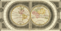
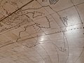
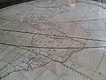
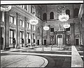
A 1746 recreation for the Amsterdam City Hall (Burgerzaal), now the Dutch Royal Palace, of an original map from 1655 that had worn flat over time.
Media in category "Burgerzaal map"
The following 24 files are in this category, out of 24 total.
-
 Eastern hemisphere - Google Art Project.jpg 4,837 × 4,837; 3.63 MB
-
 Western hemisphere - Google Art Project.jpg 4,837 × 4,837; 3.39 MB
-
 De Grondt en Vloer vande Groote Burger Sael.jpg 17,972 × 10,455; 57.1 MB
-
 Great Burgerzaal Map and Celestial Map.jpg 13,520 × 3,961; 19.4 MB
-

-
 Great Burgerzaal Map.png 2,321 × 1,200; 7.63 MB
-
 Burgerzaal in Paleis op de Dam.jpg 469 × 617; 132 KB
-
 Overzicht van de Burgerzaal in het Paleis op de Dam, Bestanddeelnr 922-5886.jpg 2,436 × 3,702; 1.61 MB
-
 Amsterdam Royal Palace P1070962.JPG 4,000 × 3,000; 4 MB
-
 Amsterdam Royal Palace P1070968.JPG 4,000 × 3,000; 3.74 MB
-
 Amsterdam Royal Palace P1080013.JPG 4,000 × 3,000; 3.52 MB
-
 Burgerzaal - Amerika.JPG 3,264 × 2,448; 1.47 MB
-
 Burgerzaal - Australië.JPG 3,264 × 2,448; 1.62 MB
-
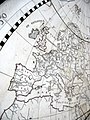
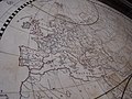
 Burgerzaal - Europa.JPG 3,264 × 2,448; 1.59 MB
-
 Burgerzaal - Ingang hoek.JPG 2,448 × 3,264; 1.11 MB
-
 Burgerzaal - Oostelijk Halfrond.JPG 3,264 × 2,448; 1.57 MB
-
 Burgerzaal - Westelijk Halfrond.JPG 3,264 × 2,448; 1.59 MB
-
 Het Paleis op de Dam 03.jpg 2,000 × 3,008; 5.16 MB
-
 Koninklijk huis, paleizen, Burgerzaal, Bestanddeelnr 020-1226.jpg 2,902 × 3,579; 1.59 MB
-
 Koninklijk huis, paleizen, Burgerzaal, Bestanddeelnr 020-1227.jpg 3,565 × 2,887; 1.42 MB
-
 Overzicht van de Burgerzaal in het Paleis op de Dam, Bestanddeelnr 922-5888.jpg 3,702 × 2,436; 1.65 MB
-
 Overzicht van de Burgerzaal in het Paleis op de Dam, Bestanddeelnr 922-5889.jpg 2,451 × 3,690; 1.51 MB
-
 Vloer Paleis op de Dam.JPG 1,200 × 1,600; 407 KB
-
 Ευρώπη στο Ανάκτορο του Άμστερνταμ 2693.jpg 4,608 × 3,456; 3.32 MB


,_RP-P-AO-21-13-15.jpg)


Categories:
- Burgerzaal
- Old maps of the Netherlands
- Joan Blaeu
- Jacob Martenesz
- Floor inlays
- Latin-language maps
- Island of California
- Maps connecting Australia and New Guinea
- Maps connecting Australia and Tasmania
- Dutch-language maps
- New Holland (Australia)
- Aethiopian Sea
- Maps of the world without Antarctica
- Terra incognita
- 1640s maps of the world
- 1740s maps of the world
- Negroland
- Cafreria
- Maps with stereographic projection
- Maps using Ferro prime meridian