Category:Chéméré
Naar navigatie springen
Naar zoeken springen
|
Chéméré heeft een ingang op OpenStreetMap (toon). |
voormalige gemeente in Loire-Atlantique, Frankrijk .jpg) _v2.svg)  | |||||
| Media uploaden | |||||
| Is een |
| ||||
|---|---|---|---|---|---|
| Locatie |
| ||||
| Opheffingsdatum |
| ||||
| Inwonertal |
| ||||
| Oppervlakte |
| ||||
| Vervangen door | |||||
| officiële website | |||||
 | |||||
Ondercategorieën
Deze categorie bevat de volgende 11 subcategorieën, van de 11 in totaal.
*
- Coats of arms of Chéméré (2 B)
A
- Aerial views of Chéméré (50 B)
F
M
- Maps of Chéméré (5 B)
N
O
P
- Postcards of Chéméré (44 B)
S
- Streets in Chéméré (57 B)
T
- Town hall of Chéméré (1 B)
Media in categorie "Chéméré"
Deze categorie bevat de volgende 12 bestanden, van in totaal 12.
-
 Chéméré, Entrée du parc de loisirs.JPG 2.560 × 1.920; 2,88 MB
-
 Chéméré, Gare - 1.JPG 1.663 × 2.217; 1,42 MB
-
 Chéméré, gare - 2.JPG 1.920 × 2.560; 2,02 MB
-
 Chéméré, Rivière de La Blanche.JPG 1.843 × 2.458; 1,93 MB
-
 L0366 - Bourg - Chéméré.JPG 4.592 × 3.056; 1,89 MB
-
 Mégalithe Chéméré 01.jpg 5.184 × 3.456; 10,75 MB
-
 Mégalithe Chéméré 02.jpg 5.184 × 3.456; 11,28 MB
-
 Mégalithe Chéméré 03.jpg 5.184 × 3.456; 10,54 MB
-
 Mégalithe Chéméré 04.jpg 5.184 × 3.456; 13,33 MB
-
 OPL Chéméré 2015 02.JPG 4.608 × 3.456; 2,51 MB
-
 OPL Chéméré 2015 133.JPG 4.608 × 3.456; 5,76 MB
-
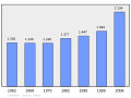 Population - Municipality code 44040.svg 475 × 355; 13 kB


