Category:Col de la Croix VD
Jump to navigation
Jump to search
| Object location | | View all coordinates using: OpenStreetMap |
|---|
road pass marking the limit between the Vaud Prealps and the Vaud Alps, Switzerland  _OSM.png) | |||||
| Upload media | |||||
| Instance of | |||||
|---|---|---|---|---|---|
| Location |
| ||||
| Mountain range | |||||
| Elevation above sea level |
| ||||
 | |||||
Subcategories
This category has the following 3 subcategories, out of 3 total.
Media in category "Col de la Croix VD"
The following 34 files are in this category, out of 34 total.
-
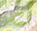
 Karte Col de la Croix VD.png 1,181 × 768; 388 KB
-
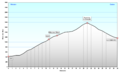 Profil Col de la Croix VD.png 1,209 × 749; 57 KB
-
 Beetles' tracks on wood (29510526127).jpg 3,456 × 5,184; 5.72 MB
-
 Beetles' tracks on wood (30579416828).jpg 3,456 × 5,184; 6.03 MB
-
 Col de la Croix (Vaud) OSM.png 699 × 597; 701 KB
-
 Col de la Croix etching 12x25cm'86.tif 1,517 × 815; 3.56 MB
-
 Col de la Croix in Switzerland by Robbie Conceptuel.jpg 4,000 × 5,333; 10.86 MB
-
 Col de la Croix near Villars Ollon 81x102cm'95.tif 1,558 × 1,215; 4.67 MB
-
 Col de la Croix VD.jpg 640 × 480; 44 KB
-
 Coldelacroix001.jpg 700 × 552; 99 KB
-
 Common Spotted Orchid - Dactylorhiza fuchsii (30585987918).jpg 3,456 × 5,184; 4.37 MB
-
 Common Spotted Orchid - Dactylorhiza fuchsii (42654994790).jpg 3,456 × 5,184; 4.37 MB
-
 Common Spotted Orchid - Dactylorhiza fuchsii (43554473255).jpg 3,456 × 5,184; 4.35 MB
-
 Common Spotted Orchid - Dactylorhiza fuchsii (43562606495).jpg 3,456 × 5,184; 4.3 MB
-
 Common Spotted Orchid - Dactylorhiza fuchsii (43562607495).jpg 3,456 × 5,184; 4.28 MB
-
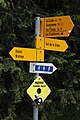 Hiking sign (42646592320).jpg 3,456 × 5,184; 4.17 MB
-
 Le Chamossaire (43490884115).jpg 5,184 × 3,456; 5.44 MB
-
 Mountain Arnica - Arnica montana (42646574770).jpg 5,184 × 3,456; 3.86 MB
-
 Pyramides de Gypse (14584128102).jpg 5,184 × 3,456; 10.27 MB
-
 Pyramides de Gypse (29451794967).jpg 5,184 × 3,456; 7.18 MB
-
 Pyramides de Gypse (30521154988).jpg 5,184 × 3,456; 7.98 MB
-
 Rust fungus on Sorbus sp. (42645646990).jpg 5,184 × 3,456; 8.04 MB
-
 Rust fungus on Sorbus sp. (43545199255).jpg 5,184 × 3,456; 4.71 MB
-
 Rust fungus on Sorbus sp. (43737814024).jpg 5,184 × 3,456; 4.79 MB
-
 Rust fungus on Sorbus sp. (44405239292).jpg 5,184 × 3,456; 4.97 MB
-
 Rust fungus on Sorbus sp. (44405282592).jpg 5,184 × 3,456; 7.27 MB
-
 Switzerland. Col de la Croix.jpg 3,648 × 2,736; 2.49 MB
-
 Tour d'Aï, Tour de Mayen and Tour de Famelon (44388486931).jpg 5,184 × 3,456; 5.45 MB
-
 Tour de Romandie 2013 - étape4 - Murs de neige dans le col de la Croix (2).jpg 4,417 × 2,945; 6.53 MB
-
 Tour de Romandie 2013 - étape4 - peloton dans le col de la Croix (2).jpg 4,991 × 3,328; 8.65 MB
-
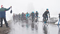 Tour de Romandie 2013 - étape4 - peloton dans le col de la Croix.jpg 6,048 × 3,395; 8.79 MB
-
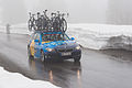 Tour de Romandie 2013 - étape4 - voiture Team Sako dans le col de la Croix (2).jpg 4,453 × 2,968; 7.24 MB
-
 Villars Mountain hut photo-etching 1984.tif 889 × 754; 2.58 MB
-
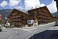 Villars-sur-Ollon B.jpg 3,008 × 2,000; 992 KB


.jpg)
.jpg)


.jpg)
.jpg)
.jpg)
.jpg)
.jpg)
.jpg)
.jpg)
.jpg)
.jpg)
.jpg)
.jpg)
.jpg)
.jpg)
.jpg)
.jpg)
.jpg)

.jpg)
.jpg)
.jpg)

.jpg)
