Category:Confusion Range
Jump to navigation
Jump to search
mountain range in Millard and Juab counties in Utah, United States  | |||||
| Upload media | |||||
| Instance of | |||||
|---|---|---|---|---|---|
| Location |
| ||||
| Width |
| ||||
| Area |
| ||||
| Elevation above sea level |
| ||||
| Different from | |||||
 | |||||
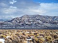
English: Media related to the Confusion Range, a mountain range in the Great Basin in Millard County, Utah, United States, that extends slightly north in to Juab County. The ranges is also known as the Conger Range, the Crystal Peak Hills, the Heckethorn Hills, the House Range, and the Perry Range.
Subcategories
This category has only the following subcategory.
K
Media in category "Confusion Range"
The following 4 files are in this category, out of 4 total.
-
 ConfusionR.JPG 3,648 × 2,432; 3.5 MB
-
 Great Basin National Park 102007 095.JPG 2,304 × 1,152; 415 KB
-
 SevierLake.JPG 2,592 × 1,936; 1 MB
-
 SnowCR.JPG 3,264 × 2,448; 5.38 MB


