Category:County Sligo
Aller à la navigation
Aller à la recherche
Comtés de la République d’Irlande : Carlow · Cavan · Clare · Cork(1) · Donegal · Dún Laoghaire-Rathdown(2) · Fingal(2) · Galway(3) · Kerry · Kildare · Kilkenny · Laois · Leitrim · Limerick · Longford · Louth · Mayo · Meath · Monaghan · Offaly · Roscommon · Sligo · South Dublin(2) · Tipperary(4) · Waterford · Westmeath · Wexford · Wicklow – Villes séparées : Cork(1) · Dublin(2) · Galway(3) – Anciens comtés : Dublin(2) · South Tipperary(4) Anciens comtés d’Irlande du Nord : Antrim · Armagh · Down · Fermanagh · Londonderry · Tyrone
comté d'Irlande    | |||||
| Téléverser des médias | |||||
| Nature de l’élément | |||||
|---|---|---|---|---|---|
| Lieu |
| ||||
| Capitale | |||||
| Assemblée délibérante |
| ||||
| Exécutif |
| ||||
| Population |
| ||||
| Superficie |
| ||||
| site officiel | |||||
 | |||||
Sous-catégories
Cette catégorie comprend 23 sous-catégories, dont les 23 ci-dessous.
A
C
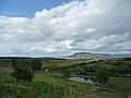
- Countryside in County Sligo (22 F)
E
G
H
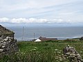
- Headlands of County Sligo (1 F)
L
- Lough Ballydawley crannógs (2 F)
M
N
P
S
- Sligo Way (8 F)
T
Y
- Yeats Trail (1 F)
Pages dans la catégorie « County Sligo »
Cette catégorie comprend seulement la page ci-dessous.
Média dans la catégorie « County Sligo »
Cette catégorie comprend 675 fichiers, dont les 200 ci-dessous.
(page précédente) (page suivante)-
 Flag of county Sligo.svg 600 × 300 ; 210 octet
-
 "Pine" - geograph.org.uk - 981226.jpg 480 × 640 ; 97 kio
-
 "Waiting On The Shore" Memorial.jpg 5 448 × 3 528 ; 10,96 Mio
-
 'The Glen' - geograph.org.uk - 4235493.jpg 822 × 1 024 ; 413 kio
-
 'Welcome to the Yeats Country' sign on the R287 - geograph.org.uk - 4788882.jpg 640 × 480 ; 107 kio
-
 20120820 27 Ireland - Co. Sligo - Coolaney (7961564234).jpg 3 648 × 2 736 ; 1,23 Mio
-
 20120820 29 Ireland - Co. Sligo - Strandhill (7961563188).jpg 3 648 × 2 736 ; 864 kio
-
 20120820 32 Ireland - Co. Sligo - Ballisadare (7961562376).jpg 3 648 × 2 736 ; 1,06 Mio
-
 20120821 09 Ireland - Co. Sligo - Rathcormack (7961561294).jpg 3 648 × 2 736 ; 1,08 Mio
-
 20120821 10 Ireland - Co. Sligo - Rathcormack (7961560342).jpg 3 648 × 2 736 ; 1,03 Mio
-
 20120821 11 Ireland - Co. Sligo - Rathcormack (7961559488).jpg 3 648 × 2 736 ; 1,25 Mio
-
 A bit of a squeeze - geograph.org.uk - 3992120.jpg 4 000 × 2 664 ; 2,74 Mio
-

-
 A long straight road - geograph.org.uk - 3070866.jpg 640 × 480 ; 353 kio
-

-

-
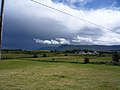
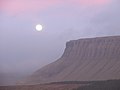
 A squall line approaching Mullaghmore Head - geograph.org.uk - 2513362.jpg 1 024 × 768 ; 164 kio
-
 A Yeats mural in central Sligo - geograph.org.uk - 5933895.jpg 576 × 1 024 ; 95 kio
-
 Abandoned cottage - geograph.org.uk - 2533151.jpg 640 × 480 ; 91 kio
-
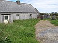
 Abandoned farm, Keelty - geograph.org.uk - 724677.jpg 640 × 454 ; 73 kio
-
 Abandoned house - geograph.org.uk - 2531407.jpg 640 × 480 ; 100 kio
-
 Across the bay and far away - geograph.org.uk - 5933947.jpg 1 024 × 576 ; 60 kio
-
 Ahamlish Parish Church near Sligo - geograph.org.uk - 2513189.jpg 1 024 × 757 ; 259 kio
-
 Aircraft in a field - geograph.org.uk - 5802238.jpg 640 × 360 ; 87 kio
-
 Alder grove - geograph.org.uk - 2537850.jpg 640 × 480 ; 90 kio
-
 Along the N17 - geograph.org.uk - 3992230.jpg 4 000 × 2 664 ; 5,68 Mio
-
 Along the N17 - geograph.org.uk - 3992270.jpg 4 000 × 2 664 ; 4,28 Mio
-
 Along the N17 - geograph.org.uk - 3992290.jpg 4 000 × 2 664 ; 4,46 Mio
-

-
 Apartment block on Sligo waterfront - geograph.org.uk - 4788594.jpg 640 × 480 ; 68 kio
-
 Approach to Baryte mines at Glencarbury - geograph.org.uk - 5304347.jpg 3 264 × 2 448 ; 2,22 Mio
-
 Approach to the N16 - geograph.org.uk - 3782242.jpg 2 592 × 1 936 ; 1,75 Mio
-
 Approaching Inishcrone - geograph.org.uk - 5802230.jpg 640 × 360 ; 69 kio
-
 Approaching Slievemore from the NW, Dartry Mountains - geograph.org.uk - 3762945.jpg 1 024 × 768 ; 143 kio
-

-
 Ardtrasna garden - geograph.org.uk - 2399344.jpg 3 072 × 2 304 ; 2,6 Mio
-
 Around Rosses Point - geograph.org.uk - 1950244.jpg 640 × 480 ; 79 kio
-
 Aughris Head Beach.jpg 4 032 × 3 024 ; 4,16 Mio
-
 Bale wrap - geograph.org.uk - 3070579.jpg 640 × 480 ; 304 kio
-
 Ballinacarrow.jpg 2 557 × 1 753 ; 809 kio
-
 Ballydawley Lough.jpg 4 032 × 2 016 ; 3,67 Mio
-
 Ballysadare River - geograph.org.uk - 3062552.jpg 480 × 640 ; 103 kio
-
 Barn, Shancough - geograph.org.uk - 3070481.jpg 640 × 480 ; 274 kio
-
 Barns in a field beside Pearse Road - geograph.org.uk - 4788886.jpg 640 × 480 ; 60 kio
-
 Bay at Cloonagh - geograph.org.uk - 2413062.jpg 640 × 480 ; 81 kio
-
 Beach at Kilrusheighter - geograph.org.uk - 1852300.jpg 640 × 480 ; 110 kio
-
 Beach Hotel, Mullaghmore - geograph.org.uk - 6217485.jpg 1 024 × 685 ; 391 kio
-
 Beach track - geograph.org.uk - 2540725.jpg 640 × 480 ; 98 kio
-
 Behind the dunes - geograph.org.uk - 2540257.jpg 640 × 480 ; 89 kio
-
 Beltra Post Office, Beltra, Co. Sligo - geograph.org.uk - 4677588.jpg 1 024 × 687 ; 191 kio
-
 Ben Bulben in distance - geograph.org.uk - 5933954.jpg 1 024 × 576 ; 81 kio
-
 Benalta - geograph.org.uk - 3072445.jpg 640 × 480 ; 285 kio
-
 Benbulben from Sligo city centre - geograph.org.uk - 5931770.jpg 1 024 × 576 ; 69 kio
-
 Benbulben's Empire Strikes Back.......... - geograph.org.uk - 3891270.jpg 4 000 × 3 000 ; 2,26 Mio
-
 Benbulbin from Lugnagall - geograph.org.uk - 5813593.jpg 640 × 427 ; 89 kio
-
 Beneath the Ox Mountains - geograph.org.uk - 3072084.jpg 640 × 360 ; 209 kio
-
 Beneath the Ox Mountains - geograph.org.uk - 3072268.jpg 640 × 360 ; 240 kio
-
 Beneath the Ox Mountains - geograph.org.uk - 3072270.jpg 640 × 360 ; 213 kio
-
 Big Gun - geograph.org.uk - 5933943.jpg 576 × 1 024 ; 168 kio
-
 Big Wave Surfer at Mullaghmore.jpg 450 × 370 ; 97 kio
-
 Bikers on the move - geograph.org.uk - 3992208.jpg 4 000 × 2 664 ; 5,48 Mio
-
 Billa Bridge - geograph.org.uk - 3062645.jpg 640 × 480 ; 300 kio
-
 Boarded up building - geograph.org.uk - 5802330.jpg 640 × 360 ; 67 kio
-
 Boarded up cottage - geograph.org.uk - 5802303.jpg 640 × 360 ; 66 kio
-
 Boat near Rosses Point - geograph.org.uk - 824524.jpg 640 × 479 ; 48 kio
-

-
 Bog Fence, Ballyconnell - geograph.org.uk - 305616.jpg 640 × 426 ; 107 kio
-
 Boreen near Knocknarea - geograph.org.uk - 5933936.jpg 576 × 1 024 ; 149 kio
-
 Boulder clay cliff - geograph.org.uk - 2531338.jpg 640 × 480 ; 100 kio
-
 Branchfield Bridge - geograph.org.uk - 3070886.jpg 640 × 480 ; 324 kio
-
 Bridge over the stream - geograph.org.uk - 2539998.jpg 640 × 480 ; 97 kio
-
 Bunduff Strand April 2020.jpg 4 032 × 3 024 ; 4,43 Mio
-
 Bunnanaddan River - geograph.org.uk - 6180969.jpg 1 024 × 768 ; 368 kio
-
 Bus stop in Pearse Road - geograph.org.uk - 4788900.jpg 640 × 453 ; 75 kio
-

-
 Car park of the Sligo Clarion Hotel - geograph.org.uk - 3783368.jpg 2 592 × 1 936 ; 1,41 Mio
-
 Carran Hill.jpg 2 560 × 1 920 ; 2,31 Mio
-
 Carranduff Farm and Cottages - geograph.org.uk - 3655731.jpg 800 × 532 ; 80 kio
-
 CARRICK-ON-SUIR RFB.jpg 1 024 × 768 ; 176 kio
-
 Carrowkeel passage tombs, aerial 2003 - geograph.org.uk - 4570676.jpg 640 × 425 ; 63 kio
-
 Carrowneden - geograph.org.uk - 3070879.jpg 640 × 480 ; 307 kio
-
 Castletown Manor House, Cottlestown, Sligo (2) - geograph.org.uk - 4075622.jpg 640 × 436 ; 301 kio
-
 Castletown Manor House, Cottlestown, Sligo (3) - geograph.org.uk - 4075624.jpg 640 × 484 ; 329 kio
-
 Catholic Church at Rathcormack - geograph.org.uk - 2719709.jpg 1 024 × 768 ; 118 kio
-
 Caves of Keash, Co.Sligo, aerial 2003 - geograph.org.uk - 3164262.jpg 640 × 423 ; 78 kio
-
 CCTV, Lough Talt - geograph.org.uk - 3072309.jpg 640 × 480 ; 239 kio
-
 Charlestown village - geograph.org.uk - 3989271.jpg 4 000 × 2 664 ; 4,21 Mio
-
-
 Church cemetery along Quay Road - geograph.org.uk - 2519590.jpg 640 × 480 ; 76 kio
-
 Clarion Hotel Sligo - geograph.org.uk - 4513218.jpg 1 600 × 1 200 ; 351 kio
-
 Clarion Sligo Hotel - geograph.org.uk - 3783370.jpg 2 592 × 1 936 ; 1,38 Mio
-
 Classiebawn and Ben Bulben.jpg 4 928 × 3 280 ; 8,38 Mio
-
 Clear felled area - geograph.org.uk - 3072276.jpg 640 × 330 ; 205 kio
-
 Clear felled area - geograph.org.uk - 3072287.jpg 640 × 360 ; 225 kio
-
 Cleft in the cliff face, Slievemore, Dartry Mountains - geograph.org.uk - 3762961.jpg 1 024 × 768 ; 193 kio
-

-
 Cleveragh Retail Park, off Cleveragh Drive, Sligo Town - geograph.org.uk - 4671515.jpg 1 024 × 674 ; 142 kio
-
 Cliffoney Celtic Home Pitch.jpg 4 032 × 3 024 ; 5,86 Mio
-
 Cliffs and wave-cut platform at Cloonagh - geograph.org.uk - 2413116.jpg 640 × 480 ; 97 kio
-
 Cliffs on northeast face of Slievemore, Dartry Mountains - geograph.org.uk - 3762963.jpg 1 024 × 768 ; 189 kio
-

-
 Clifftop field at Lislary - geograph.org.uk - 2413144.jpg 640 × 480 ; 95 kio
-
 Clooncose, aerial 2003 - geograph.org.uk - 4570636.jpg 640 × 423 ; 95 kio
-
 Clooncose, Ballymote, 2000 - geograph.org.uk - 3161559.jpg 631 × 640 ; 145 kio
-
 Clooncose, Ballymote, 2000 - geograph.org.uk - 3189229.jpg 640 × 427 ; 69 kio
-
 Clooncose, Ballymote, 2003 - geograph.org.uk - 3164313.jpg 640 × 423 ; 102 kio
-
 Clooncose, Ballymote, aerial 2003 - geograph.org.uk - 3161540.jpg 640 × 439 ; 95 kio
-
 Clooncose, house across a bank - geograph.org.uk - 3189260.jpg 640 × 434 ; 123 kio
-
 Clooncose, view across the river - geograph.org.uk - 3189251.jpg 640 × 432 ; 99 kio
-
 Clooncose, view across the river - geograph.org.uk - 3189288.jpg 640 × 423 ; 73 kio
-
 Co. Sligo countryside - geograph.org.uk - 5933925.jpg 1 024 × 576 ; 80 kio
-
 Coastal area north of the N15 - geograph.org.uk - 3648241.jpg 2 592 × 1 936 ; 1,96 Mio
-
 Coastal hamlet west of Cliffoney - geograph.org.uk - 2513234.jpg 1 024 × 768 ; 183 kio
-
 Coastal lowlands north of the N15 at Drumfad - geograph.org.uk - 2692915.jpg 1 024 × 686 ; 99 kio
-
 Colgagh Lough - geograph.org.uk - 1956941.jpg 640 × 480 ; 238 kio
-
 College Building - geograph.org.uk - 4515637.jpg 1 600 × 1 200 ; 371 kio
-
 Colours of Sligo.svg 100 × 67 ; 244 octet
-
 Colours-of-Sligo.png 100 × 67 ; 623 octet
-
 Commercial Buildings - geograph.org.uk - 4515649.jpg 1 600 × 1 200 ; 333 kio
-
 Concrete jetty on Lough Gill - geograph.org.uk - 4789024.jpg 640 × 480 ; 42 kio
-
 Coney Island - geograph.co.uk - 1624495.jpg 640 × 480 ; 50 kio
-
 Coney Island Sign, Co. Sligo.jpg 4 032 × 3 024 ; 5,46 Mio
-
 Conifer plantation near Cloonacool - geograph.org.uk - 3267939.jpg 640 × 480 ; 281 kio
-
 Coolaney - geograph.org.uk - 3070276.jpg 640 × 480 ; 304 kio
-
 Coolera Peninsula.png 2 552 × 2 464 ; 243 kio
-
 Coolera Strandhill GAA grounds.jpg 5 184 × 3 888 ; 7,51 Mio
-
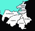 Coubty Sligo tuath map.jpg 382 × 334 ; 52 kio
-
 Country north of Cashelgarran - geograph.org.uk - 4077591.jpg 2 592 × 1 944 ; 1,18 Mio
-
 County Sligo - Drumcliffe - St Columba’s Church of Ireland (1809) - geograph.org.uk - 3994759.jpg 1 224 × 2 233 ; 1,55 Mio
-
 County Sligo - Drumcliffe Church ^ Cemetery - Informational Sign - geograph.org.uk - 3994756.jpg 2 160 × 1 449 ; 1,83 Mio
-

-

-
 County Sligo - St Columba’s Church of Ireland Interior - Chancel - geograph.org.uk - 3994760.jpg 1 903 × 1 446 ; 1,47 Mio
-
 County Sligo - St Columba’s Church of Ireland Interior - Chancel - geograph.org.uk - 3994761.jpg 1 302 × 1 302 ; 1,59 Mio
-

-
 Creevykeel Court Tomb - geograph.org.uk - 1956481.jpg 640 × 480 ; 289 kio
-
 Creevykeel Court Tomb - geograph.org.uk - 1956495.jpg 640 × 480 ; 317 kio
-
 Crosses at Streedagh Beach.jpg 3 872 × 2 592 ; 3,06 Mio
-
 Damp corner - geograph.org.uk - 2533075.jpg 640 × 480 ; 91 kio
-
 Dartry Mountains from Mullaghmore Harbour.jpg 5 416 × 3 611 ; 10,25 Mio
-
 Derelict building, near Skreen, Co. Sligo - geograph.org.uk - 4687085.jpg 1 024 × 667 ; 167 kio
-
 Derelict thatched cottage, Kilgrass - geograph.org.uk - 5802284.jpg 640 × 360 ; 82 kio
-
 Diamond Coast Hotel - geograph.org.uk - 5802232.jpg 640 × 360 ; 86 kio
-
 Drangan crossroads - geograph.org.uk - 2533113.jpg 640 × 480 ; 84 kio
-
 Drumcliff Parish Church from the car park - geograph.org.uk - 2512057.jpg 1 024 × 821 ; 321 kio
-
 Drumcliff River - geograph.org.uk - 3782188.jpg 640 × 478 ; 91 kio
-
 Drumcliff River valley - geograph.org.uk - 3782227.jpg 2 592 × 1 936 ; 1,56 Mio
-
 Drumcliffe - Round Tower ^ High Cross along N15 - geograph.org.uk - 3746230.jpg 2 979 × 1 986 ; 4,61 Mio
-
 Drumcliffe - View of King's Mountain - geograph.org.uk - 3746406.jpg 3 008 × 2 000 ; 3,7 Mio
-
 Drumcliffe Churchyard - geograph.org.uk - 4014743.jpg 640 × 375 ; 359 kio
-
 Drumcliffe Round Tower - geograph.org.uk - 2719683.jpg 1 024 × 768 ; 104 kio
-
 Dry Stone Wall on Benbulben - geograph.org.uk - 5304387.jpg 3 264 × 2 448 ; 2,55 Mio
-
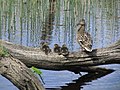 Duck ^ ducklings on Garvoge River, E of Sligo - geograph.org.uk - 4276343.jpg 1 024 × 768 ; 286 kio
-
 Dunes above Back Strand - geograph.org.uk - 2540197.jpg 640 × 480 ; 100 kio
-
 Dunes and Benbulbin - geograph.org.uk - 2540239.jpg 640 × 480 ; 95 kio
-
 Eamonn Burke Limited, Massreagh, Skreen, Co. Sligo - geograph.org.uk - 4687458.jpg 1 024 × 668 ; 125 kio
-
 Easky Abbey - geograph.org.uk - 3190356.jpg 640 × 480 ; 84 kio
-
 Easky River.jpg 4 032 × 3 024 ; 6,5 Mio
-
 East side of Knocknarea - geograph.org.uk - 2556627.jpg 640 × 480 ; 98 kio
-
 Eastern shore of the River Moy - geograph.org.uk - 2543923.jpg 800 × 557 ; 60 kio
-
 Elsinore House, Sligo.jpg 1 024 × 709 ; 86 kio
-
 Emmett Street, Tobercurry - geograph.org.uk - 3672100.jpg 640 × 480 ; 73 kio
-
 End of Benbulbin - geograph.org.uk - 4515653.jpg 1 600 × 1 200 ; 407 kio
-
 Enniscrone Beach at Sunset.jpg 1 600 × 1 200 ; 390 kio
-
 Enniscrone Beach Road - geograph.org.uk - 4677677.jpg 1 632 × 918 ; 279 kio
-
 Entering a passage tomb at Carrowkeel - geograph.org.uk - 1930302.jpg 480 × 640 ; 98 kio
-

-
 Erratic boulder - geograph.org.uk - 2556616.jpg 640 × 480 ; 90 kio
-
 Ethna's by the Sea, Mullaghmore - geograph.org.uk - 6217506.jpg 1 024 × 751 ; 781 kio
-
 Expansive grounds of stately riverfront home - geograph.org.uk - 2519568.jpg 640 × 410 ; 103 kio
-
 Farm buildings - geograph.org.uk - 5802326.jpg 640 × 360 ; 103 kio
-
 Farm buildings, Rathlee - geograph.org.uk - 5802314.jpg 640 × 360 ; 81 kio
-
 Farm track, Carrownaleck - geograph.org.uk - 3070961.jpg 640 × 480 ; 301 kio
-
 Farm, Carrowneden - geograph.org.uk - 3070875.jpg 640 × 480 ; 276 kio
-
 Farmstead - geograph.org.uk - 5802220.jpg 640 × 360 ; 93 kio
-
 Farmyard paraphernalia - geograph.org.uk - 2542361.jpg 640 × 480 ; 95 kio
-
 Farmyard with abandoned cottage - geograph.org.uk - 2533178.jpg 640 × 480 ; 89 kio
-
 Feeney's Costcutter (1), Dromore West, Co. Sligo - geograph.org.uk - 4689278.jpg 1 024 × 673 ; 149 kio
-
 Feeney's Costcutter (2), Dromore West, Co. Sligo - geograph.org.uk - 4689302.jpg 1 024 × 655 ; 137 kio
-
 Fence sections, Truskmore - geograph.org.uk - 1880132.jpg 640 × 424 ; 99 kio
-
 Field at Cashelgarran - geograph.org.uk - 3549504.jpg 2 592 × 1 936 ; 1,59 Mio
-
 Field at Cashelgarran - geograph.org.uk - 3643802.jpg 2 592 × 1 936 ; 1,76 Mio
-
 Field by the Drumcliff River - geograph.org.uk - 3782197.jpg 2 592 × 1 936 ; 1,37 Mio
-
 Field near Lugnagall, close to Glencar Lough - geograph.org.uk - 3782237.jpg 2 592 × 1 936 ; 1,49 Mio
-
 Fields - geograph.org.uk - 4515646.jpg 1 600 × 1 200 ; 482 kio
-
 Fishing boat wreck, Streedagh, Co. Sligo.jpg 1 280 × 960 ; 161 kio
-
 Flag poles in Pearse Road - geograph.org.uk - 4788908.jpg 640 × 480 ; 61 kio
-
 Flowers on mullaghmore.jpg 4 032 × 3 024 ; 4,91 Mio
-
 Footbridge over Garavogue River in Sligo - geograph.org.uk - 5007005.jpg 1 024 × 682 ; 208 kio
-
 Footbridge over the River Garavogue - geograph.org.uk - 4788600.jpg 640 × 480 ; 88 kio
-
 Ford at Cloontyprocklis - geograph.org.uk - 2399273.jpg 3 072 × 2 048 ; 2,63 Mio
-
 Ford over the Dunneill River - geograph.org.uk - 1852236.jpg 640 × 480 ; 111 kio
-
 Forest margin - geograph.org.uk - 2541847.jpg 640 × 480 ; 90 kio
-
 Former O'Connor public house (1), near Skreen, Co. Sligo - geograph.org.uk - 4686844.jpg 1 024 × 683 ; 142 kio
-

-
 Former school at Masshill - geograph.org.uk - 4967174.jpg 4 000 × 3 000 ; 3,35 Mio
-
 Fulmars at Knocklane Hill - geograph.org.uk - 2716745.jpg 1 024 × 768 ; 143 kio
-
 Garavogue River on eastern edge of Sligo - geograph.org.uk - 5007008.jpg 1 024 × 682 ; 200 kio
-
 Garden at Sea Town - geograph.org.uk - 2399282.jpg 2 796 × 1 839 ; 2 Mio
-
 Garvoge River Sligo - geograph.org.uk - 4966410.jpg 4 320 × 3 240 ; 3,22 Mio


.jpg)
.jpg)
.jpg)
.jpg)
.jpg)
.jpg)


_-_geograph.org.uk_-_4075622.jpg)
_-_geograph.org.uk_-_4075624.jpg)


_-_geograph.org.uk_-_3994759.jpg)


,_Dromore_West,_Co._Sligo_-_geograph.org.uk_-_4689278.jpg)
,_Dromore_West,_Co._Sligo_-_geograph.org.uk_-_4689302.jpg)


,_near_Skreen,_Co._Sligo_-_geograph.org.uk_-_4686844.jpg)
_-_detail,_near_Skreen,_Co._Sligo_-_geograph.org.uk_-_4687041.jpg)


