Category:Crabble Mill
Jump to navigation
Jump to search
| Object location | | View all coordinates using: OpenStreetMap |
|---|
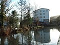
watermill in River, Kent  | |||||
| Upload media | |||||
| Instance of | |||||
|---|---|---|---|---|---|
| Location | River, Dover, Kent, South East England, England | ||||
| Occupant |
| ||||
| Heritage designation |
| ||||
 | |||||
This is a category about listed building number 1070318. |
Media in category "Crabble Mill"
The following 6 files are in this category, out of 6 total.
-
 Crabble Corn Mill - Dover, Kent, UK - panoramio (1).jpg 1,100 × 825; 460 KB
-
 Crabble Corn Mill - Dover, Kent, UK - panoramio.jpg 1,250 × 800; 490 KB
-
 Crabble Corn Mill - geograph.org.uk - 4255589.jpg 2,272 × 1,704; 775 KB
-
 Crabble Mill - geograph.org.uk - 99798.jpg 640 × 480; 105 KB
-
 Crabble water mill - geograph.org.uk - 2096856.jpg 480 × 640; 190 KB
-
 Crabble Mill - geograph.org.uk - 207558.jpg 418 × 640; 95 KB
.jpg)


