Category:Craimoosweiher
Jump to navigation
Jump to search
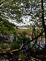
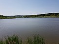
lake in Bavaria, Germany  | |||||
| Upload media | |||||
| Instance of | |||||
|---|---|---|---|---|---|
| Located in protected area | |||||
| Location | Schnabelwaid, Bayreuth, Upper Franconia, Bavaria, Germany | ||||
| Area |
| ||||
| Elevation above sea level |
| ||||
| Outflows |
| ||||
 | |||||
This is the category of the protected area listed at WDPA under the ID 162685
|
This is the category of the protected area listed at WDPA under the ID 555521378
|
Deutsch: Craimoosweiher ist ein Naturschutzgebiet (NSG-00257.01) und FFH-Gebiet (6135-301) bei Schnabelwaid im Landkreis Bayreuth
Media in category "Craimoosweiher"
The following 20 files are in this category, out of 20 total.
-
 Abfluss des Weihergrabens.JPG 2,048 × 1,536; 1.14 MB
-
 Baumbestand am Weihergraben (südlicher Abfluß des Craimoosweihers)-Panorama.jpg 8,192 × 1,856; 4.06 MB
-
 Baumbestand am Weihergraben (südlicher Abfluß des Craimoosweihers).jpg 5,456 × 3,632; 8.16 MB
-
 Craimoosweiher vom Norden.jpg 5,456 × 3,632; 8.78 MB
-
 Craimoosweiher.JPG 2,048 × 1,536; 1 MB
-
 Landschaftsschutzgebiet "Craimoosweiher" - 2.jpg 3,264 × 2,448; 2.54 MB
-
 Landschaftsschutzgebiet "Craimoosweiher" - 3.jpg 3,264 × 2,448; 1.47 MB
-
 Landschaftsschutzgebiet "Craimoosweiher" - 4.jpg 4,000 × 3,000; 4.04 MB
-
 Landschaftsschutzgebiet Craimoosweiher 1.jpg 4,000 × 3,000; 3.03 MB
-
 Naturschutzgebiet Craimoosweiher 01.jpg 4,032 × 3,024; 2.54 MB
-
 Naturschutzgebiet Craimoosweiher 02.jpg 4,032 × 3,024; 4.62 MB
-
 Naturschutzgebiet Craimoosweiher 03.jpg 4,032 × 3,024; 2.8 MB
-
 Naturschutzgebiet Craimoosweiher 04.jpg 3,024 × 4,032; 6.9 MB
-
 Naturschutzgebiet Craimoosweiher 05.jpg 4,032 × 3,024; 6.91 MB
-
 Naturschutzgebiet Craimoosweiher 06.jpg 4,032 × 3,024; 7.79 MB
-
 Naturschutzgebiet Craimoosweiher 07.jpg 4,032 × 3,024; 4.04 MB
-
 Naturschutzgebiet Craimoosweiher 08.jpg 3,000 × 4,000; 4.51 MB
-
 Naturschutzgebiet Craimoosweiher 09.jpg 4,000 × 3,000; 3.27 MB
-
 Panoramafoto Craimossweiher bei Schnabelwaid.jpg 6,609 × 1,172; 1.56 MB
-
 Schwanenfamilie auf dem Craimoosweiher.jpg 5,456 × 3,632; 5.81 MB

.jpg)


-Panorama.jpg)