Category:Cronenburgh (buitenplaats)
Jump to navigation
Jump to search
| Object location | | View all coordinates using: OpenStreetMap |
|---|
 | |||||
| Upload media | |||||
| Instance of | |||||
|---|---|---|---|---|---|
| Location | Loenen aan de Vecht, Stichtse Vecht, Utrecht, Netherlands | ||||
| Has part(s) | |||||
| Heritage designation |
| ||||
 | |||||
Nederlands: Cronenburgh is een monumentale buitenplaats langs de rivier de Vecht bij het Nederlandse dorp Loenen aan de Vecht.
|
This is a category about rijksmonumentcomplex number 520356
|
| Address |
|
Media in category "Cronenburgh (buitenplaats)"
The following 6 files are in this category, out of 6 total.
-
 Jaagpad ophaalbrug ter hoogte van Bloklaan - Loenen aan de Vecht - 20141744 - RCE.jpg 1,192 × 1,200; 433 KB
-
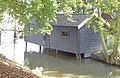 Loenen aan de Vecht - Cronenburgh botenhuis RM520362.JPG 4,113 × 2,660; 913 KB
-
 Loenen aan de Vecht - Cronenburgh dierenverblijf RM520364.JPG 4,443 × 3,216; 4.29 MB
-
 Loenen aan de Vecht - Cronenburgh ophaalbrug RM520363.JPG 3,456 × 4,300; 1.73 MB
-
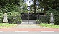 Loenen aan de Vecht - Cronenburgh toegangshek RM520361.JPG 4,446 × 2,600; 1.56 MB
-
 Loenen aan de Vecht - Cronenburgh tuinhuis RM520360.JPG 3,470 × 3,387; 1.2 MB


