Category:Disputed territories
Przejdź do nawigacji
Przejdź do wyszukiwania
Disputed territories. See also en:Category:Divided regions on English Wikipedia.

territory, which status is controversial between two or more existing states | |||||
| Prześlij plik multimedialny | |||||
| Podklasa dla |
| ||||
|---|---|---|---|---|---|
| Inne niż | |||||
| |||||
Podkategorie
Poniżej wyświetlono 36 spośród wszystkich 36 podkategorii tej kategorii.
!
+
A
- Aouzou Strip (19 plików)
B
C
- China's nine-dash demarcation line (9 plików)
- Counani (3 pliki)
F
G
H
I
- Ilemi Triangle (11 plików)
K
M
P
R
T
Strony w kategorii „Disputed territories”
W tej kategorii jest tylko jedna strona.
Pliki w kategorii „Disputed territories”
Poniżej wyświetlono 24 spośród wszystkich 24 plików w tej kategorii.
-
 Couto Misto.JPG 1600 × 1200; 812 KB
-
 Davis and Nancy Fields - Harlan and Letcher County.jpg 300 × 204; 39 KB
-
 DisputedBorderScheme01.jpg 419 × 487; 15 KB
-
 Flag map of Abyei.png 1744 × 1247; 398 KB
-
 Flag map of Cyprus(de facto).png 1601 × 603; 98 KB
-
 Flag map of Republic of China.png 4328 × 3357; 522 KB
-
 Flag map of the Western sahara.png 1616 × 1499; 122 KB
-
 Former and Russian-occupied Ukrainian territories.png 5869 × 3286; 210 KB
-
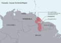 Guyana Venezuela border controversy map.png 8420 × 5950; 1,65 MB
-
 Iraqi Counter Terrorism in Qarachugh Mountain.jpg 1232 × 816; 115 KB
-
 ISFDeaths.jpg 1022 × 770; 61 KB
-
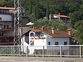 Josko Joras' house.jpg 2091 × 1568; 1,15 MB
-
 Lajtabánság címere.gif 305 × 303; 5 KB
-
 Mapa de Guyana.png 667 × 600; 128 KB
-
 Mongtai.png 124 × 68; 2 KB
-
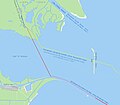 Musura border.jpg 944 × 828; 327 KB
-
 Máltai koronás logo.jpg 587 × 1091; 295 KB
-
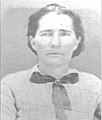 Nancy Bennett Whitley County.jpg 300 × 353; 28 KB
-
 Scn+c-cover.jpg 369 × 479; 52 KB
-
 Seal of the Ridgetop Shawnee Tribe of Indians.png 422 × 390; 161 KB
-
 Silas Montgomery and Aggie Sizemore - Clay County.jpg 300 × 189; 32 KB
-
 The original Kushans on the land of Baron Rothschild in Horan.jpg 858 × 644; 50 KB
-
 WorldWithRegionsBorders.png 4974 × 2519; 575 KB
-
Óglaigh na hÉireann.ogg 1,3 s; 21 KB


.png)