Category:El Meüll
Jump to navigation
Jump to search
| Object location | | View all coordinates using: OpenStreetMap |
|---|
human settlement in Castell de Mur, Pallars Jussà, Alt Pirineu i Aran, Spain  | |||||
| Upload media | |||||
| Instance of |
| ||||
|---|---|---|---|---|---|
| Part of |
| ||||
| Location | Castell de Mur, Pallars Jussà, Lleida Province, Catalonia | ||||
| Elevation above sea level |
| ||||
 | |||||
Català: El Meüll, nucli del municipi de Castell de Mur, al Pallars Jussà)
Subcategories
This category has the following 15 subcategories, out of 15 total.
C
- Camí de la Serra (el Meüll) (1 F)
- Casa Auberola (1 F)
- Casa Farmicó (3 F)
- Casa Sallamana (1 F)
- Castell del Meüll (2 F)
E
- Els Pous (el Meüll) (1 F)
L
- Lo Planell (el Meüll) (1 F)
M
- Mas de Condó (4 F)
- Mas de l'Hereu (el Meüll) (2 F)
P
- Planell de Sallamana (2 F)
S
- Sant Martí del Meüll (3 F)
- Sellamana (2 F)
- Serra del Meüll (2 F)
- Serrat de la Vinyeta (1 F)
T
- Tros de Sellamana (1 F)
Media in category "El Meüll"
The following 6 files are in this category, out of 6 total.
-
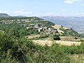
 Castell de Mur. El Meüll 2.JPG 2,592 × 1,944; 1.25 MB
-
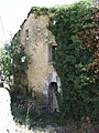
 Castell de Mur. Mur. El Meüll 3.JPG 2,592 × 1,944; 1.29 MB
-
 Castell de Mur. Mur. El Meüll 4.JPG 2,592 × 1,944; 1.27 MB
-
 Castell de Mur. Mur. El Meüll 5.JPG 1,944 × 2,592; 1.22 MB
-
 Castell de Mur. Mur. El Meüll 7.JPG 2,592 × 1,944; 1.26 MB
-
 Castell de Mur. Mur. El Meüll 8.JPG 2,592 × 1,944; 1.26 MB


