Category:Emery County, Utah
Пређи на навигацију
Пређи на претрагу
Counties of Utah: Beaver · Box Elder · Cache · Carbon · Daggett · Davis · Duchesne · Emery · Garfield · Grand · Iron · Juab · Kane · Millard · Morgan · Piute · Rich · Salt Lake · San Juan · Sanpete · Sevier · Summit · Tooele · Uintah · Utah · Wasatch · Washington · Wayne · Weber
county in east-central Utah, United States    | |||||
| Отпремање медија | |||||
| Је | |||||
|---|---|---|---|---|---|
| Названо по |
| ||||
| Локација | Јута, САД | ||||
| Престоница | |||||
| Настанак |
| ||||
| Насељеност |
| ||||
| Површина |
| ||||
| званични веб-сајт | |||||
 | |||||
English: Media related to Emery County, Utah, a county in eastern Utah, United States.
Поткатегорије
Приказано је 14 поткатегорија; укупно 14.
B
C
- Crandall Canyon Mine (4 F)
E
G
H
M
N
- Nature of Emery County, Utah (4 F)
P
S
- Signs in Emery County, Utah (25 F)
T
Медији у категорији „Emery County, Utah”
Следећих 92 датотека је у овој категорији, од укупно 92.
-

-

-
 2018 06 17-16.53.05.813-CDT.jpg 1.200 × 900; 257 kB
-

-

-
 Badlands Shadows, Utah 8-12 (21493165385).jpg 2.800 × 1.969; 1,96 MB
-
 Black Canyon Dragon - panoramio.jpg 1.476 × 1.040; 518 kB
-
 Book Cliffs viewed the from the California Zephyr near Green River in Emery County, UT.jpg 3.264 × 2.448; 1,99 MB
-
 Bowknot Bend of the Green River in Utah 2015.jpg 16.100 × 2.613; 1,32 MB
-
 Bowknot Bend Overlook, Labyrinth Canyon, DyeClan.com - panoramio (1).jpg 4.000 × 3.000; 1,44 MB
-
 Bowknot Bend Overlook, Labyrinth Canyon, DyeClan.com - panoramio (2).jpg 4.000 × 3.000; 1,51 MB
-
 Bowknot Bend Overlook, Labyrinth Canyon, DyeClan.com - panoramio (3).jpg 3.000 × 4.000; 1,33 MB
-
 Bowknot Bend Overlook, Labyrinth Canyon, DyeClan.com - panoramio (4).jpg 4.000 × 3.000; 1,6 MB
-
 Bowknot Bend Overlook, Labyrinth Canyon, DyeClan.com - panoramio.jpg 4.000 × 3.000; 1,05 MB
-
 Buckhorn Wash Campground - panoramio.jpg 1.920 × 478; 240 kB
-
 California Zephyr north of Green River.jpg 1.882 × 1.080; 383 kB
-
 Canyonlands, UT.jpg 1.600 × 1.200; 638 kB
-
 Dinosaur Bone Fossil dyeclan.com - panoramio.jpg 4.272 × 2.848; 4,72 MB
-
 Eagle Canyon Sunrise from Justesen Flats Bluff - panoramio.jpg 4.784 × 1.200; 975 kB
-
 East Edge of San Rafael Swell (5074102896).jpg 1.286 × 854; 423 kB
-
 Eclipse at San Rafeal Swell - panoramio.jpg 3.495 × 2.370; 1,96 MB
-
 Emery County Seal.png 130 × 78; 3 kB
-
 Emery County, UT, USA - panoramio (1).jpg 3.264 × 2.448; 3,3 MB
-
 Emery County, UT, USA - panoramio (2).jpg 3.264 × 2.448; 3,33 MB
-
 Emery County, UT, USA - panoramio (24).jpg 3.264 × 2.448; 1,69 MB
-
 Emery County, UT, USA - panoramio (25).jpg 3.264 × 2.448; 1,79 MB
-
 Emery County, UT, USA - panoramio (28).jpg 3.264 × 2.448; 2,36 MB
-
 Emery County, UT, USA - panoramio (29).jpg 3.264 × 2.448; 2,47 MB
-
 Emery County, UT, USA - panoramio (3).jpg 3.264 × 2.448; 3,97 MB
-
 Emery County, UT, USA - panoramio (30).jpg 3.264 × 2.448; 2,72 MB
-
 Emery County, UT, USA - panoramio (31).jpg 2.336 × 3.504; 2,93 MB
-
 Emery County, UT, USA - panoramio (32).jpg 3.504 × 2.336; 2,99 MB
-
 Emery County, UT, USA - panoramio (33).jpg 3.504 × 2.336; 3,17 MB
-
 Emery County, UT, USA - panoramio (34).jpg 3.504 × 2.336; 3,65 MB
-
 Emery County, UT, USA - panoramio (35).jpg 3.504 × 2.336; 3,09 MB
-
 Emery County, UT, USA - panoramio (36).jpg 3.504 × 2.336; 2,85 MB
-
 Emery County, UT, USA - panoramio (37).jpg 3.504 × 2.336; 3,05 MB
-
 Emery County, UT, USA - panoramio (38).jpg 3.504 × 2.336; 3,27 MB
-
 Emery County, UT, USA - panoramio (39).jpg 3.504 × 2.336; 2,5 MB
-
 Emery County, UT, USA - panoramio (4).jpg 3.264 × 2.448; 3,51 MB
-
 Emery County, UT, USA - panoramio (40).jpg 3.504 × 2.336; 2,52 MB
-
 Emery County, UT, USA - panoramio (41).jpg 3.504 × 2.336; 3,3 MB
-
 Emery County, UT, USA - panoramio (42).jpg 3.504 × 2.336; 3,43 MB
-
 Emery County, UT, USA - panoramio (5).jpg 3.264 × 2.448; 3,3 MB
-
 Emery County, UT, USA - panoramio (6).jpg 4.912 × 3.264; 5,06 MB
-
 Emery County, UT, USA - panoramio (7).jpg 4.912 × 3.264; 5,08 MB
-
 Emery County, UT, USA - panoramio (9).jpg 3.264 × 2.448; 1,62 MB
-
 Emery county1 ut sr10.jpg 1.536 × 1.024; 531 kB
-
 Emery county2 ut sr10.jpg 1.536 × 1.024; 512 kB
-
 Eremogone sp. in the flatlands west of the Green River, UT, USA.jpg 3.468 × 4.624; 3,78 MB
-
 Erosion Effects - Utah - DPLA - 7fff4fd625193061fd96ed647e905895.jpg 4.785 × 3.888; 3,14 MB
-
 Exhumedchannel.jpg 869 × 590; 378 kB
-
 Huntington plant 2.jpg 4.032 × 3.024; 868 kB
-
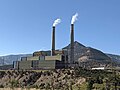 Huntington plant.jpg 4.032 × 3.024; 816 kB
-
 I-70 GreenRiver looking east - panoramio.jpg 5.312 × 2.988; 3,02 MB
-
 Little Grand Canyon, Emery County, Utah 02.jpg 1.316 × 1.754; 635 kB
-
 Moore.jpg 3.072 × 1.728; 2,91 MB
-
 More i-70 east - panoramio.jpg 1.600 × 782; 319 kB
-
 Motel 6 Green River.jpg 4.032 × 3.024; 849 kB
-
 MuddyCreekChuteUT.jpg 600 × 979; 110 kB
-
 Petroglyph - panoramio.jpg 2.048 × 1.536; 692 kB
-
 Petroglyphs in Petroglyph Canyon dyeclan.com - panoramio.jpg 3.264 × 2.448; 6,9 MB
-
 Reclaimability analysis of the Emery coal field, Emery County, Utah (IA reclaimabilityan00hodd).pdf 1.210 × 1.595, 596 страница; 35,46 MB
-
 San Rafael Swell - panoramio.jpg 1.472 × 1.040; 588 kB
-
 San Rafael Swell 4892197401.jpg 4.288 × 2.488; 10,31 MB
-
 San Rafael Swell 4892804322.jpg 4.288 × 2.848; 12,29 MB
-
 San Rafael Swell, Spotted Wolf Pass, Utah I-70E (6003186378).jpg 2.259 × 1.638; 976 kB
-
 San Rafeal Swell - panoramio.jpg 1.448 × 1.036; 360 kB
-
 San Rafeal Swell, Spotted Wof Pass, I-70E (6003393824).jpg 2.272 × 1.696; 1,13 MB
-
 San Rafeal Swell, Spotted Wolf Pass, Utah, I-70E (6003395564).jpg 2.218 × 1.536; 1,02 MB
-
 San Rafeal Swell, Spotted Wolf Pass, Utah, I-70E (6003396262).jpg 1.149 × 1.729; 589 kB
-
 Sandstone Cave on Trail to Rochester Panel DyeClan.com - panoramio.jpg 3.264 × 1.952; 1,63 MB
-
 SanRafaelReefUT.jpg 918 × 600; 130 kB
-
 Sunset Sandstones - Entrada near, Navajo far (4058207221).jpg 1.600 × 1.067; 428 kB
-
 The Early Morning Zephyr between Helper and Green River Utah - panoramio.jpg 2.799 × 1.934; 680 kB
-
 The First Ride (27120851).jpeg 2.048 × 1.512; 1,02 MB
-
 The Wytiahlowsky Boulder with rainbow, August 2011.jpg 960 × 640; 270 kB
-

-
 This shot was taken on the train from Helper Utah to Green River Utah - panoramio.jpg 2.906 × 1.983; 539 kB
-
 Tree Full of Shoes dyeclan.com - panoramio.jpg 4.000 × 3.000; 7,01 MB
-
 Two Rock Art Panels - panoramio.jpg 3.264 × 1.952; 1,46 MB
-
 USA Emery County, Utah age pyramid.svg 520 × 600; 8 kB
-
 Utah Badlands, west of Green River, Utah.jpg 2.800 × 2.103; 2,02 MB
-
 Utah Bluffs - panoramio.jpg 2.048 × 1.536; 765 kB
-
 Utah Scene - Flickr - Me in ME.jpg 1.920 × 1.243; 540 kB
-
 Utah Sky - panoramio.jpg 2.511 × 2.013; 2,95 MB
-
View from California Zephyr Train.webm 16 с, 3.840×2.160; 13,3 MB
-
 Wide Open - panoramio.jpg 4.096 × 1.024; 2,11 MB
-
 Wildflowers in the Spring dyeclan.com - panoramio.jpg 4.272 × 2.848; 4,86 MB
-
 Ylbdc 1b (8602456433).jpg 3.405 × 1.968; 1,45 MB
-
 Ylbdc 2b (8602457115).jpg 2.800 × 1.599; 1.008 kB
-
 Ylbdc 3b (8602457999).jpg 2.800 × 2.010; 1,41 MB


.jpg)


.jpg)
.jpg)
.jpg)
.jpg)


.jpg)

.jpg)
.jpg)
.jpg)
.jpg)
.jpg)
.jpg)
.jpg)
.jpg)
.jpg)
.jpg)
.jpg)
.jpg)
.jpg)
.jpg)
.jpg)
.jpg)
.jpg)
.jpg)
.jpg)
.jpg)
.jpg)
.jpg)
.jpg)
.jpg)
.jpg)


.jpg)

.jpg)
.jpg)
.jpg)


.jpg)

.jpeg)


.jpg)
.jpg)
.jpg)