Category:Enchanted Rock
Zur Navigation springen
Zur Suche springen
Granitkuppe im US-Bundesstaat Texas  | |||||
| Medium hochladen | |||||
| Ist ein(e) | |||||
|---|---|---|---|---|---|
| Material | |||||
| Liegt in Schutzgebiet | |||||
| Ort | Llano County, Texas | ||||
| Schutzkategorie |
| ||||
| Gebirgszug |
| ||||
| Schartenhöhe |
| ||||
| Climbing route | |||||
| Höhe über dem Meeresspiegel |
| ||||
 | |||||
|
Diese Kategorie enthält Dateien zu einem Objekt, das im National Register of Historic Places der Vereinigten Staaten verzeichnet ist. Die Referenznummer lautet 84001740. |
Medien in der Kategorie „Enchanted Rock“
Folgende 38 Dateien sind in dieser Kategorie, von 38 insgesamt.
-
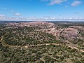 Aerial View of Enchanted Rock.jpg 4.000 × 3.000; 10 MB
-
 Chuck Norris Was Here.jpg 3.872 × 2.592; 9,57 MB
-
 Enchanted Rock (50753440137).jpg 6.048 × 3.400; 8,78 MB
-
 Enchanted rock 0001.jpg 720 × 405; 48 KB
-
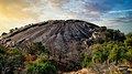
 Enchanted Rock 2005.jpg 2.048 × 1.536; 626 KB
-
 Enchanted rock 2006.jpg 640 × 480; 59 KB
-
 Enchanted Rock 360 Panorama.jpg 12.962 × 1.274; 5,09 MB
-
 Enchanted Rock Nima (10).JPG 1.548 × 1.038; 578 KB
-
 Enchanted Rock Panorama 2012.jpg 12.799 × 3.787; 25,95 MB
-
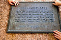 Enchanted Rock Plaque.jpg 1.152 × 759; 1,27 MB
-
 Enchanted Rock Summit.jpg 4.000 × 3.000; 2,17 MB
-
 Enchanted Rock Sunset (50751965261).jpg 5.528 × 3.110; 5,84 MB
-
 Enchanted rock texas (1783058583).jpg 2.471 × 1.648; 429 KB
-
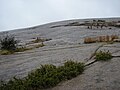
 Enchanted Rock Vernal Pool.png 1.165 × 654; 1,02 MB
-
 Enchanted Rock view from the top.jpg 3.008 × 2.000; 569 KB
-
 Enchanted Rock View.png 1.600 × 762; 2,09 MB
-
 Enchanted Rock, 2005.jpg 2.048 × 1.536; 610 KB
-
 Enchanted Rock, dome.jpg 2.048 × 1.536; 627 KB
-
 Enchanted Rock-02-Ueberblick-1982-gje.jpg 3.840 × 2.299; 4,16 MB
-
 Enchanted Rock-04-1982-gje.jpg 3.840 × 2.541; 3,96 MB
-
 Enchanted Rock-06-1982-gje.jpg 3.840 × 2.182; 2,96 MB
-
 Enchanted Rock-08-1982-gje.jpg 3.840 × 2.348; 2,83 MB
-
 Enchanted Rock-10-1982-gje.jpg 3.720 × 2.380; 3,25 MB
-
 Enchanted Rock-18-1982-gje.jpg 1.920 × 2.923; 2,33 MB
-
 Enchanted Rock-20-Ausblick-1982-gje.jpg 3.840 × 2.541; 4,05 MB
-
 Enchanted rock.jpg 4.032 × 3.024; 1,67 MB
-
 Enchanted-Rock-July-2008-Clouds.jpg 3.872 × 2.592; 10,43 MB
-
 Enchanted-Rock-July-2008-More-Clouds.jpg 3.872 × 2.592; 7,27 MB
-
 GeologicalExfoliationOfGraniteRock.jpg 2.048 × 1.360; 2,65 MB
-
 Highway Approaching Enchanted Rock.jpg 5.184 × 2.916; 9,54 MB
-
 Hill Country Sunrise - Enchanted Rock, Texas (50756054336).jpg 6.048 × 3.400; 8,29 MB
-
 Little Rock View.jpg 3.008 × 2.000; 565 KB
-
 To the summit of Enchanted Rock, TX IMG 0424.JPG 4.066 × 2.711; 2,01 MB
-
 Vernal Pool Enchanted Rock.jpg 600 × 408; 98 KB
-
 Vernal Pools Enchanted Rock SNA Texas 2023.jpg 2.999 × 2.000; 5,59 MB
-
 View from half-way down Enchanted Rock.jpg 3.008 × 2.000; 648 KB
-
 View from the top of enchanted rock facing park entrance.jpg 3.008 × 2.000; 360 KB
-
 View of Enchanted Rock from base camp.jpg 3.008 × 2.000; 950 KB


.jpg)


.JPG)


.jpg)
.jpg)


.jpg)


Kategorien:
- Rock formations in Texas
- Geology of Texas
- National Register of Historic Places in Gillespie County, Texas
- National Register of Historic Places in Llano County, Texas
- Rock formations in the United States
- Enchanted Rock State Natural Area
- Inselbergs in the United States
- Granite domes in Texas
- Archaeological sites on the National Register of Historic Places in Texas
- Llano, Texas
- Historic districts on the National Register of Historic Places in Texas
- Historic districts in Texas