Category:Engestraat 2-4, Deventer
Jump to navigation
Jump to search
| Object location | | View all coordinates using: OpenStreetMap |
|---|
building in Deventer, Netherlands  | |||||
| Upload media | |||||
| Instance of | |||||
|---|---|---|---|---|---|
| Location | Deventer, Overijssel, Netherlands | ||||
| Street address |
| ||||
| Heritage designation |
| ||||
 | |||||
|
This is a category about rijksmonument number 12544
|
| Address |
|
Media in category "Engestraat 2-4, Deventer"
The following 23 files are in this category, out of 23 total.
-
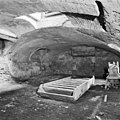
 Doorgang in kelder, tuinpand - Deventer - 20055847 - RCE.jpg 1,195 × 1,200; 352 KB
-
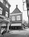
 Engestr. 2 hoek Stroomarkt - Deventer - 20055828 - RCE.jpg 967 × 1,200; 271 KB
-
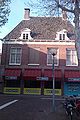
 Engestr. 2-4, gevel - Deventer - 20055833 - RCE.jpg 950 × 1,200; 245 KB
-
 Engestr. 2-4, gevel - Deventer - 20055834 - RCE.jpg 948 × 1,200; 240 KB
-
 Engestr. 2-4, voorgevels - Deventer - 20055829 - RCE.jpg 805 × 1,200; 186 KB
-
 Engestraat 2-4 Deventer.jpg 1,712 × 2,560; 1.61 MB
-
 Engestraat 2-4, gevel - Deventer - 20055830 - RCE.jpg 1,200 × 956; 221 KB
-
 Engestraat 2-4, gevel - Deventer - 20055831 - RCE.jpg 1,200 × 962; 259 KB
-
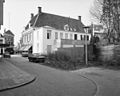
 Engestraat 2-4, overzicht - Deventer - 20055835 - RCE.jpg 1,200 × 965; 225 KB
-
 Grote kelder in tuinpand - Deventer - 20055849 - RCE.jpg 1,200 × 1,192; 303 KB
-
 Grote kelder in tuinpand - Deventer - 20055850 - RCE.jpg 1,200 × 1,188; 306 KB
-
 Kelder (modemagazijn) - Deventer - 20055842 - RCE.jpg 1,200 × 962; 187 KB
-
 Kelder - Deventer - 20055840 - RCE.jpg 944 × 1,200; 211 KB
-
 Kelder - Deventer - 20055841 - RCE.jpg 1,200 × 955; 173 KB
-
 Kelder - Deventer - 20055843 - RCE.jpg 1,200 × 952; 159 KB
-
 Kelder tuinpand - Deventer - 20055848 - RCE.jpg 1,200 × 1,192; 328 KB
-
 Kelder tuinpand - Deventer - 20055851 - RCE.jpg 1,200 × 1,200; 308 KB
-
 Overzicht - Deventer - 20056629 - RCE.jpg 1,200 × 804; 171 KB
-
 Schouw in grote kelder tuinpand - Deventer - 20055852 - RCE.jpg 1,190 × 1,200; 399 KB
-
 Stromarkt naar Engestraat - Deventer - 20054135 - RCE.jpg 1,190 × 1,200; 313 KB
-
 Tuinpand - voor en zijgevel - Deventer - 20055845 - RCE.jpg 1,200 × 954; 273 KB
-
 Tuinpand voor en zijgevel - Deventer - 20055846 - RCE.jpg 966 × 1,200; 245 KB
-
 Tuinpand- voorgevel - Deventer - 20055844 - RCE.jpg 1,200 × 954; 229 KB


_-_Deventer_-_20055842_-_RCE.jpg)


