Category:Era de Ca n'Oriol
Jump to navigation
Jump to search
| Object location | | View all coordinates using: OpenStreetMap |
|---|
 | |||||
| Upload media | |||||
| Instance of | |||||
|---|---|---|---|---|---|
| Location | Rubí, Barcelona Province, Catalonia | ||||
| Heritage designation |
| ||||
 | |||||
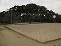
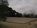
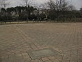
Català: Era de Ca n'Oriol, situada davant la masia homònima, al parc de Ca n'Oriol (Rubí). De forma quadrangular, presenta un interessant enrajolat disposat en sentit diagonal a l'eix de l'era. Conserva cinc lloses amb inscripcionsen llatí, fetes col·locar per Pau Viver i Oriol, situades al centre de cada un dels quatre costats i al mig. La làpida central, la més
gran, consisteix en un bloc de pedra de forma rectangular amb el text emmarcat per una greca.
This is a category about a building indexed in the Catalan heritage register as Bé Cultural d'Interès Local (BCIL) under the reference IPA-39014. |
Media in category "Era de Ca n'Oriol"
The following 9 files are in this category, out of 9 total.
-
 182 Era de Ca n'Oriol.jpg 2,272 × 1,704; 1 MB
-
 183 Era de Ca n'Oriol.jpg 2,272 × 1,704; 989 KB
-
 184 Era de Ca n'Oriol.jpg 1,704 × 2,272; 1.28 MB
-
 185 Era de Ca n'Oriol.jpg 2,272 × 1,704; 1.1 MB
-
 186 Era de Ca n'Oriol.jpg 2,272 × 1,704; 1.11 MB
-
 187 Era de Ca n'Oriol.jpg 2,272 × 1,704; 1.21 MB
-
 188 Era de Ca n'Oriol.jpg 2,272 × 1,704; 1.22 MB
-
 Era de Ca n'Oriol (Rubí) 2012-10-01 22-28-32.jpg 2,592 × 1,552; 1.63 MB
-
 Era de Ca n'Oriol (Rubí) 2012-10-01 22-29-59.jpg 2,592 × 1,552; 1.51 MB


_2012-10-01_22-28-32.jpg)
_2012-10-01_22-29-59.jpg)