Category:Flèche de Leethe
Jump to navigation
Jump to search
Nederlands: Zie De verdedigingswerken van de Lethe voor meer informatie.
| Object location | | View all coordinates using: OpenStreetMap |
|---|
 | |||||
| Upload media | |||||
| Instance of | |||||
|---|---|---|---|---|---|
| Location | Bellingwedde, Westerwolde, Groningen, Netherlands | ||||
| Street address |
| ||||
| Heritage designation |
| ||||
 | |||||
|
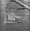
This is a category about rijksmonument number 8909
|
| Address |
|
Media in category "Flèche de Leethe"
The following 5 files are in this category, out of 5 total.
-
 De Lethe Fleche.JPG 2,288 × 1,712; 2.27 MB
-
 Luchtfoto (Batterij) - Bellingwolde - 20030169 - RCE.jpg 1,192 × 1,200; 374 KB
-
 Luchtfoto (Batterij) - Bellingwolde - 20030170 - RCE.jpg 1,188 × 1,200; 372 KB
-
 Luchtfoto (Batterij) - Bellingwolde - 20030171 - RCE.jpg 1,190 × 1,200; 517 KB
-

_-_Bellingwolde_-_20030169_-_RCE.jpg)
_-_Bellingwolde_-_20030170_-_RCE.jpg)
_-_Bellingwolde_-_20030171_-_RCE.jpg)
