Category:Fontaine des Boucheries
Jump to navigation
Jump to search
| Object location | | View all coordinates using: OpenStreetMap |
|---|
|
This building is classé au titre des monuments historiques de la France. It is indexed in the base Mérimée, a database of architectural heritage maintained by the French Ministry of Culture, under the reference PA00078786
|
 | |||||
| Upload media | |||||
| Instance of | |||||
|---|---|---|---|---|---|
| Location | Reims, arrondissement of Reims, Marne, Grand Est, Metropolitan France, France | ||||
| Located on street | |||||
| Owned by | |||||
| Heritage designation |
| ||||
 | |||||
Media in category "Fontaine des Boucheries"
The following 17 files are in this category, out of 17 total.
-
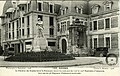 B514546101 BMR56-336.jpg 1,105 × 703; 1.02 MB
-
 B514546101 fontaine boucherie Plan Héteau 1844.jpg 463 × 218; 56 KB
-
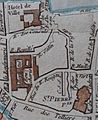
 B514546101 XXXII II i TGF22 Plan Héteau 1844 (rue Talleyrand).jpg 618 × 410; 97 KB
-
 Fontaine BouCheries Varin 30138.jpg 3,267 × 2,414; 6.46 MB
-
 Fontaine des boucheries 1006595.jpg 1,732 × 2,761; 1.04 MB
-
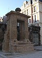
 Fontaine des Boucheries.jpg 768 × 1,024; 237 KB
-
 Fontaine des bouchers.jpg 2,286 × 3,189; 970 KB
-
 Place des boucheries 1006594.jpg 2,349 × 1,832; 930 KB
-
 Place Jules-Lobet 20%.jpg 796 × 518; 226 KB
-
 Povillon fontaine des boucheries reims.JPG 957 × 1,738; 1.16 MB
-
 Povillon église pierre hotel ville reims.JPG 372 × 454; 177 KB
-
 Reims - fontaine des boucheries (01).JPG 2,448 × 3,264; 3.15 MB
-
 Reims - fontaine des boucheries (02).JPG 2,448 × 3,264; 2.74 MB
-
 Reims - fontaine des boucheries (03).JPG 2,448 × 3,264; 3.52 MB
-
 Reims - fontaine des boucheries (04).JPG 2,448 × 3,264; 3.5 MB
-
 Reims - fontaine des boucheries (05).JPG 2,448 × 3,264; 2.89 MB
-
 Reims portal and kathedral.jpg 2,592 × 1,944; 1.41 MB


.jpg)


.JPG)
.JPG)
.JPG)
.JPG)
.JPG)
