Category:Gare de Mitry - Claye
Jump to navigation
Jump to search
| Object location | | View all coordinates using: OpenStreetMap |
|---|
railway station in Mitry-Mory, France  | |||||
| Upload media | |||||
| Instance of |
| ||||
|---|---|---|---|---|---|
| Location | Mitry-Mory, Seine-et-Marne, Île-de-France, Metropolitan France, France | ||||
| Transport network | |||||
| Owned by | |||||
| Operator | |||||
| Inception |
| ||||
| Date of official opening |
| ||||
| Elevation above sea level |
| ||||
| Connecting line | |||||
| Adjacent station | |||||
 | |||||
Media in category "Gare de Mitry - Claye"
The following 36 files are in this category, out of 36 total.
-
 Gare de Mitry - Claye 01.jpg 2,560 × 1,920; 1.27 MB
-
 Gare de Mitry - Claye 02.jpg 2,560 × 1,920; 1.28 MB
-
 Gare de Mitry - Claye 03.jpg 2,560 × 1,920; 1.25 MB
-
 Gare de Mitry - Claye 04.jpg 2,560 × 1,920; 1.23 MB
-
 Gare de Mitry - Claye 05.jpg 2,560 × 1,920; 1.26 MB
-
 Gare de Mitry - Claye 06.jpg 2,560 × 1,920; 1.28 MB
-
 Gare Mitry - Claye arbre.jpg 4,288 × 3,216; 3.37 MB
-
 Gare Mitry Claye Mitry Mory 1.jpg 4,032 × 3,024; 3.33 MB
-
 Gare Mitry Claye Mitry Mory 10.jpg 4,032 × 3,024; 2.61 MB
-
 Gare Mitry Claye Mitry Mory 11.jpg 4,032 × 3,024; 3.36 MB
-
 Gare Mitry Claye Mitry Mory 12.jpg 4,032 × 3,024; 3.35 MB
-
 Gare Mitry Claye Mitry Mory 13.jpg 4,032 × 3,024; 3 MB
-
 Gare Mitry Claye Mitry Mory 14.jpg 4,032 × 3,024; 3.32 MB
-
 Gare Mitry Claye Mitry Mory 15.jpg 4,032 × 3,024; 2.95 MB
-
 Gare Mitry Claye Mitry Mory 16.jpg 4,032 × 3,024; 2.96 MB
-
 Gare Mitry Claye Mitry Mory 17.jpg 4,032 × 3,024; 2.92 MB
-
 Gare Mitry Claye Mitry Mory 18.jpg 4,032 × 3,024; 2.9 MB
-
 Gare Mitry Claye Mitry Mory 19.jpg 4,032 × 3,024; 2.88 MB
-
 Gare Mitry Claye Mitry Mory 2.jpg 4,032 × 3,024; 3.35 MB
-
 Gare Mitry Claye Mitry Mory 20.jpg 4,032 × 3,024; 2.8 MB
-
 Gare Mitry Claye Mitry Mory 3.jpg 4,032 × 3,024; 2.79 MB
-
 Gare Mitry Claye Mitry Mory 4.jpg 4,032 × 3,024; 2.81 MB
-
 Gare Mitry Claye Mitry Mory 5.jpg 4,032 × 3,024; 2.79 MB
-
 Gare Mitry Claye Mitry Mory 6.jpg 4,032 × 3,024; 3.46 MB
-
 Gare Mitry Claye Mitry Mory 7.jpg 4,032 × 3,024; 3.44 MB
-
 Gare Mitry Claye Mitry Mory 8.jpg 4,032 × 3,024; 3.49 MB
-
 Gare Mitry Claye Mitry Mory 9.jpg 4,032 × 3,024; 2.63 MB
-
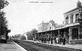 Gare-Mitry-Mory-CPancienne.jpg 1,636 × 1,028; 997 KB
-
 Mitry - Claye Transilien.jpg 4,288 × 3,216; 3.51 MB
-
 Photo.mi79.5.png 1,334 × 758; 1.38 MB
-
 RER B - Gare Mitry 2.JPG 2,304 × 1,728; 736 KB
-
 RER B - Gare Mitry 3.JPG 2,304 × 1,728; 843 KB
-
 RER B - Gare Mitry.JPG 2,304 × 1,728; 771 KB
-
 RIB by Gare Mitry - Claye.jpg 4,288 × 3,216; 3.62 MB
-
 Work train bij Mitry - Claye.jpg 4,288 × 3,216; 3.53 MB
-
 Z50000 à Mitry.jpg 3,047 × 1,944; 1.36 MB


