Category:Gasthof Adler, Fluh 11, Bregenz Vbg
Jump to navigation
Jump to search
| Object location | | View all coordinates using: OpenStreetMap |
|---|
 | |||||
| Upload media | |||||
| Instance of | |||||
|---|---|---|---|---|---|
| Location | Bregenz, Bregenz District, Vorarlberg, Austria | ||||
| Street address |
| ||||
| Heritage designation | |||||
 | |||||
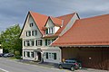
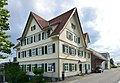
Deutsch: Vor dem Bau der Straße durch den Wirtatobel war der direkte Zugang von Bregenz zum Rothachtal über Langen nur über die Passhöhen Fluh und Stollen und der dazwischenliegenden Senke des Wirtatobels möglich. Der Gasthof Adler war der Rastpunkt auf der ersten Passhöhe (Fluh).
Media in category "Gasthof Adler, Fluh 11, Bregenz Vbg"
The following 10 files are in this category, out of 10 total.
-
 Gasthof Adler Nordostseite, Fluh 11, Bregenz Vbg.JPG 3,072 × 2,304; 1.68 MB
-
 Gasthof Adler Südseite, Fluh 11, Bregenz Vbg.JPG 2,304 × 3,072; 1.71 MB
-
 Gasthof Adler, Fluh 11 Bregenz, Böhringer 1.JPG 5,413 × 3,609; 7.04 MB
-
 Gasthof Adler, Fluh 11 Bregenz, Böhringer 2.JPG 5,790 × 3,860; 7.84 MB
-
 Gasthof Adler, Fluh 11 Bregenz, Böhringer 3.JPG 7,001 × 4,847; 11.49 MB
-
 Gasthof Adler, Fluh 11 Bregenz, Böhringer 4.JPG 6,484 × 4,489; 10.15 MB
-
 Gasthof Adler, Strraßenseite, Fluh 11, Bregenz Vbg.JPG 3,072 × 2,304; 1.75 MB
-
 Gasthof Adler, Südwestseite, Fluh 11, Bregenz Vbg.JPG 3,072 × 2,304; 1.74 MB
-
 Gasthof Adler, Terrassenraum, Fluh 11, Bregenz Vbg.jpg 3,072 × 2,304; 1.69 MB
-
 Gasthof Adler,Wirtshausschild, Fluh 11, Bregenz Vbg.JPG 3,072 × 2,304; 1.71 MB


