Category:Gilcrux
Naar navigatie springen
Naar zoeken springen
plaats in Cumbria  | |||||
| Media uploaden | |||||
| Is een | |||||
|---|---|---|---|---|---|
| Locatie | Allerdale, Cumbria, North West England, Engeland | ||||
 | |||||
Ondercategorieën
Deze categorie bevat de volgende 3 subcategorieën, van de 3 in totaal.
Media in categorie "Gilcrux"
Deze categorie bevat de volgende 71 bestanden, van in totaal 71.
-
 Approaching Gilcrux - geograph.org.uk - 4328736.jpg 2.592 × 1.944; 1,09 MB
-
 Approaching Greengill from Gilcrux - geograph.org.uk - 4328737.jpg 2.592 × 1.944; 1,59 MB
-
 Bar and Restaurant, Gilcrux - geograph.org.uk - 5005436.jpg 2.000 × 1.500; 1,61 MB
-
 Bend in the road - geograph.org.uk - 4000233.jpg 3.296 × 2.472; 3,65 MB
-
 Big Whitehouse, Greengill - geograph.org.uk - 4000259.jpg 3.296 × 2.472; 3,43 MB
-
 Boarded up house, Gilcrux - geograph.org.uk - 5005451.jpg 2.000 × 1.500; 1,51 MB
-
 Chapel Well, Gilcrux - geograph.org.uk - 1805351.jpg 3.296 × 2.472; 1,91 MB
-
 Country road east of Gilcrux - geograph.org.uk - 5005397.jpg 2.000 × 1.500; 2,03 MB
-
 County lane south of Gilcrux - geograph.org.uk - 5005455.jpg 2.000 × 1.500; 2,25 MB
-
 Ellenhall Bridge - geograph.org.uk - 463752.jpg 640 × 480; 99 kB
-
 Entrance to East House farmyard - geograph.org.uk - 5005402.jpg 2.000 × 1.500; 1,43 MB
-
 Eweclose Farm - geograph.org.uk - 5004169.jpg 2.000 × 1.500; 1,8 MB
-
 Farm buildings in Gilcrux - geograph.org.uk - 5005425.jpg 2.000 × 1.500; 2,02 MB
-
 Farm track to Homerigg - geograph.org.uk - 4000274.jpg 2.472 × 3.296; 3,49 MB
-
 Farmland, Gilcrux - geograph.org.uk - 4329113.jpg 640 × 427; 171 kB
-
 Fields at Grange Farm - geograph.org.uk - 4911658.jpg 2.592 × 1.944; 1,12 MB
-
 Gilcrux village hall - geograph.org.uk - 5005417.jpg 2.000 × 1.500; 1,47 MB
-
 Gilcrux Village Hall - geograph.org.uk - 578539.jpg 640 × 480; 232 kB
-
 Grass fields at Eweclose farm - geograph.org.uk - 5004174.jpg 2.000 × 1.500; 2,03 MB
-
 Grassfield west of Grange Farm - geograph.org.uk - 5005388.jpg 2.000 × 1.500; 1,98 MB
-
 Grassland on Wardhall Common - geograph.org.uk - 5004160.jpg 2.000 × 1.500; 2,18 MB
-
 Grassland south of Gilcrux - geograph.org.uk - 5005462.jpg 2.000 × 1.500; 1,85 MB
-
 Hatching Well, Gilcrux - geograph.org.uk - 5005411.jpg 2.000 × 1.500; 2,84 MB
-
 House and Barn Conversion, Gilcrux - geograph.org.uk - 65427.jpg 640 × 480; 83 kB
-
 House at High Flatt Farm - geograph.org.uk - 5005396.jpg 2.000 × 1.500; 1,99 MB
-
 Lane to High Flatt Farm - geograph.org.uk - 5005392.jpg 2.000 × 1.500; 2,27 MB
-
 Lindall Mount, Gilcrux - geograph.org.uk - 1805357.jpg 3.296 × 2.472; 1,79 MB
-
 Meadow at Wardhall Common - geograph.org.uk - 5004167.jpg 2.000 × 1.500; 2,11 MB
-
 Old Cumberland Road Sign - geograph.org.uk - 4000299.jpg 1.787 × 2.198; 1,87 MB
-
 Plantation on Wardhall Common - geograph.org.uk - 5004166.jpg 1.500 × 2.000; 2,88 MB
-
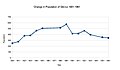 Populationchange.jpg 1.309 × 766; 91 kB
-
 Post and phone boxes in Gilcrux - geograph.org.uk - 5005428.jpg 2.000 × 1.500; 1,55 MB
-
 Radio Beacon on Wardhall Common - geograph.org.uk - 5004158.jpg 2.000 × 1.500; 1,56 MB
-
 Road junction at the west end of Gilcrux - geograph.org.uk - 5005441.jpg 2.000 × 1.500; 1,4 MB
-
 Social Status, based on 1831 occupatial statistics, Gilcrux.jpg 1.309 × 766; 71 kB
-
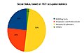 Social Status, based on 1831 occupational statistics, Gilcrux.jpg 1.426 × 906; 102 kB
-
 St Mary's church, Gilcrux - geograph.org.uk - 4911668.jpg 2.517 × 1.730; 748 kB
-
 Stile and Public Footpath - geograph.org.uk - 89696.jpg 640 × 427; 179 kB
-
 Tall Hedge near Gilcrux - geograph.org.uk - 4000227.jpg 3.296 × 2.472; 3,49 MB
-
 Terraced cottages near Gilcrux - geograph.org.uk - 1805338.jpg 3.296 × 2.472; 1,85 MB
-
 The Barn Bistro, Gilcrux - February 2018 - geograph.org.uk - 5667861.jpg 1.250 × 860; 912 kB
-
 Track at Eweclose Farm - geograph.org.uk - 5004173.jpg 2.000 × 1.500; 1,67 MB
-
 Wardhall Cottages - geograph.org.uk - 5005378.jpg 2.000 × 1.500; 1,53 MB
-
 Wild Meadow Grass - geograph.org.uk - 4000337.jpg 3.296 × 2.472; 3,52 MB
-
 A Green Lane - geograph.org.uk - 181508.jpg 640 × 480; 141 kB
-
 Beck Bridge at farms entrance. - geograph.org.uk - 84126.jpg 640 × 480; 81 kB
-
 Bridleway to Gilcrux - geograph.org.uk - 578566.jpg 640 × 480; 130 kB
-
 Bridleway to Gilcrux. - geograph.org.uk - 84124.jpg 640 × 480; 72 kB
-
 Bullclose Beck - geograph.org.uk - 89682.jpg 427 × 640; 158 kB
-
 Crossroads and Scotland. - geograph.org.uk - 84122.jpg 640 × 480; 64 kB
-
 Crossroads to Tallentire Farm. - geograph.org.uk - 84123.jpg 640 × 480; 75 kB
-
 Footpath to Oughterside - geograph.org.uk - 463769.jpg 640 × 480; 135 kB
-
 Gate - geograph.org.uk - 463775.jpg 640 × 480; 153 kB
-
 Gilcrux Fishery - geograph.org.uk - 89984.jpg 640 × 427; 66 kB
-
 Gilcrux Village Green - geograph.org.uk - 578544.jpg 640 × 480; 236 kB
-
 Grange Grassings. - geograph.org.uk - 84127.jpg 640 × 480; 90 kB
-
 Greengill House - geograph.org.uk - 49886.jpg 640 × 480; 84 kB
-
 Hatching Well - geograph.org.uk - 578549.jpg 640 × 480; 126 kB
-
 Hatching Well, Gilcrux - geograph.org.uk - 105022.jpg 640 × 480; 109 kB
-
 High Flats Farm. - geograph.org.uk - 84129.jpg 640 × 480; 76 kB
-
 Hill Farm. - geograph.org.uk - 95504.jpg 640 × 341; 42 kB
-
 Masons Arms, Gilcrux - geograph.org.uk - 578552.jpg 640 × 480; 172 kB
-
 Mill Stone Moor Farm. - geograph.org.uk - 86938.jpg 640 × 480; 87 kB
-
 Moorfield Stables - geograph.org.uk - 49885.jpg 640 × 480; 132 kB
-
 Tallentire Hill and Wood. - geograph.org.uk - 84120.jpg 640 × 480; 45 kB
-
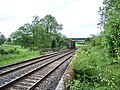 The Carlisle to Maryport Railway - geograph.org.uk - 463759.jpg 640 × 480; 158 kB
-
 The Miners Arms, Prospect - geograph.org.uk - 599193.jpg 640 × 480; 162 kB
-
 The road from Gilcrux to Tallentire Hill - geograph.org.uk - 578563.jpg 640 × 433; 173 kB
-
 Track to Oughterside - geograph.org.uk - 463742.jpg 640 × 480; 101 kB
-
 Wardhall Guards. - geograph.org.uk - 84130.jpg 640 × 480; 81 kB
-
 Yarling Well, Gilcrux - geograph.org.uk - 105024.jpg 640 × 480; 109 kB


