Category:Glandyfi
Jump to navigation
Jump to search
village in the United Kingdom  | |||||
| Upload media | |||||
| Instance of | |||||
|---|---|---|---|---|---|
| Location | Ceredigion, Wales | ||||
 | |||||
Cymraeg: Pentref yng ngogledd Ceredigion yw Glandyfi. Lleolir ger glan yr Afon Dyfi, ar ffordd yr A487 rhwng Machynlleth ac Aberystwyth, a thri chwarter milltir i'r de o Orsaf Reilffordd Cyffordd Dyfi. Lleolir Castell Glandyfi gerllaw, a adeiladwyd ym 1810, yn agos i safle Castell Aberdyfi sy'n dyddio o 1156.
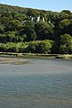
English: Glandyfi is a small hamlet in the county of Ceredigion in Wales on the A487 trunk road from Machynlleth to Aberystwyth. Glandyfi Castle, built in 1810, is located nearby close to the site of Aberdyfi Castle which dates back to 1156.
Subcategories
This category has the following 2 subcategories, out of 2 total.
D
- Dyfi Castle (3 F)
G
- Glandyfi railway station (7 F)
Media in category "Glandyfi"
The following 7 files are in this category, out of 7 total.
-
 Afon Dyfi from Glandyfi station geograph-3375531-by-Ben-Brooksbank.jpg 2,406 × 1,448; 2.59 MB
-
 Auction of Carreg farm, Glandyfi (10977754954).jpg 606 × 438; 80 KB
-
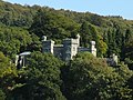 Glandyfi Castle (geograph 2042271 cropped).jpg 1,006 × 754; 257 KB
-
 Glandyfi Castle (geograph 2042271).jpg 2,000 × 3,008; 1.47 MB
-
 Glandyfi Castle NLW3360967.jpg 569 × 435; 39 KB
-
 Railway near Glandyfi - geograph.org.uk - 34380.jpg 640 × 480; 149 KB
-


.jpg)
.jpg)
.jpg)


