Category:Gough Island
Zur Navigation springen
Zur Suche springen
|
Diese Stätte ist als UNESCO-Welterbe unter der Bezeichnung
Gough and Inaccessible Islands gekennzeichnet.
|
Insel im Südatlantik  Typický povrch ostrova   | |||||
| Medium hochladen | |||||
| Ist ein(e) | |||||
|---|---|---|---|---|---|
| Ist Teil von |
| ||||
| Ort | Atlantischer Ozean, Internationale Gewässer | ||||
| Liegt am oder im Gewässer | |||||
| Schutzkategorie |
| ||||
| Zeitpunkt der Entdeckung oder Erfindung |
| ||||
| Breite |
| ||||
| Länge |
| ||||
| Höchster Punkt |
| ||||
| Einwohnerzahl |
| ||||
| Fläche |
| ||||
| Höhe über dem Meeresspiegel |
| ||||
 | |||||
Medien in der Kategorie „Gough Island“
Folgende 22 Dateien sind in dieser Kategorie, von 22 insgesamt.
-
 1954stampGoughTristan.jpg 400 × 284; 57 KB
-
 1955coverGoughIsland.jpg 1.236 × 837; 296 KB
-
 1955postGoughIslandSurvey.jpg 1.544 × 907; 370 KB
-
 3halfpenceGoughIsland.jpg 500 × 308; 48 KB
-
 Blechnum and Phylica on Gough Island.jpg 1.183 × 1.868; 443 KB
-
 Blechnum and Phylica.png 1.183 × 1.868; 2,98 MB
-
 Gallinula comeri Beintema.jpg 711 × 568; 131 KB
-
 Gough Island - EVS Precision Map (1-52,000).png 1.276 × 900; 98 KB
-
 Gough Island EVS Precision Map 1 52000-sepia.png 1.276 × 900; 3,29 MB
-
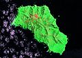 Gough Island Landsat.jpg 1.259 × 879; 139 KB
-
 Gough Island Map.jpg 1.240 × 904; 436 KB
-
 Gough Island top view.jpg 735 × 554; 101 KB
-
 Gough island top view.png 738 × 559; 697 KB
-
 Gough.png 760 × 939; 226 KB
-
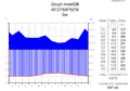 Klimadiagramm-deutsch-Gough-Insel-GB.png 1.024 × 713; 107 KB
-
 LocationGough.PNG 465 × 303; 12 KB
-
 Ophiomitrella ingrata (MNHN-IE-2013-10308) 01.jpg 4.724 × 3.307; 936 KB
-
 Ophiomitrella ingrata (MNHN-IE-2013-10308) 02.jpg 4.724 × 3.307; 1,08 MB
-
 Ophiomitrella ingrata (MNHN-IE-2013-10308) 03.jpg 4.724 × 3.307; 1,33 MB
-
 Orthographic projection over Gough Island.png 488 × 487; 20 KB
-
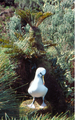
 Thalassarche chlororhynchos on Gough Island.jpg 737 × 1.190; 277 KB
-
 Thalassarche chlororhynchos.png 744 × 1.190; 1,57 MB


.png)


_01.jpg)
_02.jpg)
_03.jpg)


