Category:Guildhall, Sandwich, Kent
Jump to navigation
Jump to search
| Object location | | View all coordinates using: OpenStreetMap |
|---|
building in Sandwich, Kent, United Kingdom  | |||||
| Upload media | |||||
| Instance of | |||||
|---|---|---|---|---|---|
| Location | Sandwich, Dover, Kent, South East England, England | ||||
| Heritage designation |
| ||||
 | |||||
This is a category about listed building number 1069731. |
Media in category "Guildhall, Sandwich, Kent"
The following 23 files are in this category, out of 23 total.
-
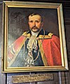 Alderman Henry Watts, painting at Sandwich Guildhall.jpg 2,258 × 2,708; 1.89 MB
-
 Guildhall - geograph.org.uk - 3026067.jpg 640 × 430; 66 KB
-
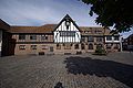
 Guildhall Sandwich (4906558345).jpg 4,230 × 2,370; 4.35 MB
-
 Guildhall, Cattle Market, Sandwich. - geograph.org.uk - 471597.jpg 640 × 427; 86 KB
-
 Guildhall, Sandwich - geograph.org.uk - 4363041.jpg 3,264 × 2,448; 2.31 MB
-
 Notice in the Guildhall, Sandwich (geograph 6070820).jpg 640 × 467; 77 KB
-
 Sandwich - 2008 - geograph.org.uk - 3431189.jpg 2,272 × 1,704; 754 KB
-
 Sandwich - Guildhall (geograph 6634532).jpg 5,152 × 2,773; 5.02 MB
-
 Sandwich Guildhall (geograph 7475786).jpg 1,024 × 684; 187 KB
-
 Sandwich Guildhall (geograph 7475787).jpg 1,024 × 684; 152 KB
-
 Sandwich Guildhall (geograph 7475788).jpg 1,024 × 684; 153 KB
-
 Sandwich Guildhall - geograph.org.uk - 503083.jpg 640 × 480; 117 KB
-
 Sandwich Kent Rathaus.jpg 3,872 × 2,592; 1.11 MB
-
 Sandwich, Cattle Market and Guildhall - geograph.org.uk - 651565.jpg 640 × 480; 61 KB
-

-
 Sandwich, the Guildhall - geograph.org.uk - 651449.jpg 640 × 480; 56 KB
-
 Seating Beside the Guildhall, Sandwich - geograph.org.uk - 2476780.jpg 800 × 533; 591 KB
-
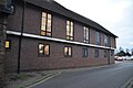
 The Guildhall (geograph 7579274).jpg 1,024 × 685; 108 KB
-
 The Guildhall (geograph 7579280).jpg 1,024 × 684; 155 KB
-
 The Guildhall - geograph.org.uk - 3026058.jpg 640 × 463; 82 KB
-

-
 The Guildhall, Sandwich - geograph.org.uk - 2476756.jpg 800 × 533; 426 KB
-
 The Guildhall, Sandwich - geograph.org.uk - 3023801.jpg 640 × 430; 54 KB


.jpg)


.jpg)

.jpg)
.jpg)
.jpg)
.jpg)


.jpg)
.jpg)


