Category:Hervormde Kerk, Echteld
Jump to navigation
Jump to search
| Object location | | View all coordinates using: OpenStreetMap |
|---|
church building in Neder-Betuwe, Netherlands  | |||||
| Upload media | |||||
| Instance of | |||||
|---|---|---|---|---|---|
| Location | Echteld, Gelderland, Netherlands | ||||
| Street address |
| ||||
| Heritage designation |
| ||||
 | |||||
Kerk:
|
This is a category about rijksmonument number 14267
|
Toren:
|
This is a category about rijksmonument number 14268
|
| Address |
|
Subcategories
This category has only the following subcategory.
I
Media in category "Hervormde Kerk, Echteld"
The following 44 files are in this category, out of 44 total.
-
 Detail mortel met baksteen gruis zuidgevel schip. - Echteld - 20065902 - RCE.jpg 1,200 × 788; 355 KB
-
 Detail noordgevel - Echteld - 20065896 - RCE.jpg 1,192 × 1,200; 579 KB
-
 Detail secundair materiaal zuidgevel schip - Echteld - 20065900 - RCE.jpg 1,190 × 1,200; 556 KB
-

-
 Detail zuidingang schip - Echteld - 20065898 - RCE.jpg 1,200 × 1,195; 553 KB
-
 Door C.Pronk 1728 in Gemeente Museum Arnhem - Echteld - 20065870 - RCE.jpg 954 × 1,200; 234 KB
-
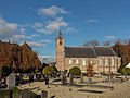
 ECHTELD HERVORMDE KERK 01.jpg 4,608 × 3,456; 3.08 MB
-
 ECHTELD HERVORMDE KERK 02.jpg 4,608 × 3,456; 3.34 MB
-
 Echteld toren NH kerk-1.jpg 2,448 × 3,264; 1.47 MB
-
 Echteld toren NH kerk-2.jpg 2,448 × 3,264; 1.85 MB
-
 Echteld, de Hervormde Kerk RM14267 foto3 2014-11-24 13.34.jpg 4,352 × 3,264; 10.62 MB
-
 Echteld, kerk positie2 foto5 2011-05-1 13.21.jpg 4,416 × 3,312; 8.87 MB
-
 En kasteel overzicht vanuit het zuiden - Echteld - 20065871 - RCE.jpg 1,200 × 1,186; 386 KB
-
 En kasteel overzicht vanuit het zuiden - Echteld - 20378785 - RCE.jpg 1,200 × 1,186; 406 KB
-
 Exterieur naar het noord-westen - Echteld - 20065874 - RCE.jpg 1,200 × 950; 280 KB
-
 Exterieur ZUIDGEVEL - Echteld - 20268926 - RCE.jpg 1,177 × 1,200; 375 KB
-

-
 Exterieur ZUIDGEVEL, GEDEELTE - Echteld - 20268927 - RCE.jpg 1,190 × 1,200; 440 KB
-
 Exterieur ZUIDGEVEL, OVERZICHT - Echteld - 20268925 - RCE.jpg 1,186 × 1,200; 386 KB
-
 Fragment van wandschildering in koor - Echteld - 20065879 - RCE.jpg 983 × 1,200; 236 KB
-
 Gedeelte van de noordgevel - Echteld - 20065893 - RCE.jpg 1,195 × 1,200; 401 KB
-
 Kerken, exterieur, nh kerk, Bestanddeelnr 165-0225.jpg 2,603 × 2,632; 1.26 MB
-

-
 N-H St.Jan-de-Doper-Kerk Echteld.jpg 3,264 × 2,448; 1.52 MB
-
 Oorlogsschade - Echteld - 20065872 - RCE.jpg 1,200 × 822; 258 KB
-
 Oorlogsschade - Echteld - 20065873 - RCE.jpg 1,200 × 818; 307 KB
-
 Oostgevel - Echteld - 20065890 - RCE.jpg 950 × 1,200; 319 KB
-
 Oostgevel, detail steunbeer - Echteld - 20371209 - RCE.jpg 783 × 1,200; 294 KB
-
 Overzicht ingangspartij zuidgevel - Echteld - 20371205 - RCE.jpg 783 × 1,200; 291 KB
-
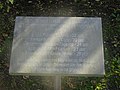 Plaquette Crashlocatie Vickers Wellington Echteld.jpg 4,896 × 3,672; 6.6 MB
-
 Portaal deur - Echteld - 20065887 - RCE.jpg 818 × 1,200; 266 KB
-
 Primair materiaal) - Echteld - 20065901 - RCE.jpg 1,200 × 1,192; 617 KB
-
 Raam noordgevel schip - Echteld - 20065894 - RCE.jpg 1,200 × 1,200; 430 KB
-
 Raam noordgevel schip - Echteld - 20065895 - RCE.jpg 1,185 × 1,200; 351 KB
-
 Reliëf in steunbeer zuid-zijde van het koor - Echteld - 20065883 - RCE.jpg 1,200 × 953; 300 KB
-
 Toegang in de zuid muur - Echteld - 20065875 - RCE.jpg 945 × 1,200; 377 KB
-
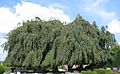 Treurbeuk.jpg 1,600 × 988; 695 KB
-
 Zicht vanuit het oosten tijdens restauratie - Echteld - 20326868 - RCE.jpg 915 × 1,200; 184 KB
-
 Zicht vanuit het zuidoosten tijdens restauratie - Echteld - 20325136 - RCE.jpg 1,200 × 913; 217 KB
-
 Zuid-gevel na de restauratie - Echteld - 20065886 - RCE.jpg 1,200 × 810; 243 KB
-
 Zuid-west gevel - Echteld - 20065888 - RCE.jpg 955 × 1,200; 259 KB
-
 Zuidgevel - Echteld - 20065889 - RCE.jpg 1,200 × 955; 281 KB
-
 Zuidgevel - Echteld - 20065897 - RCE.jpg 1,195 × 1,200; 447 KB
-
 Zuidzijde koor, aanzicht reliëf steunbeer - Echteld - 20371208 - RCE.jpg 783 × 1,200; 219 KB


_-_Echteld_-_20065901_-_RCE.jpg)


