Category:Hervormde Kerk, Wognum
Jump to navigation
Jump to search
| Object location | | View all coordinates using: OpenStreetMap |
|---|
 | |||||
| Upload media | |||||
| Instance of |
| ||||
|---|---|---|---|---|---|
| Location | Wognum, Medemblik, North Holland, Netherlands | ||||
| Street address |
| ||||
| Heritage designation |
| ||||
 | |||||
Kerk:
|
This is a category about rijksmonument number 39315
|
Toren:
|
This is a category about rijksmonument number 39316
|
| Address |
|
Media in category "Hervormde Kerk, Wognum"
The following 64 files are in this category, out of 64 total.
-
 Aanzet gewelf in toren - Wognum - 20216546 - RCE.jpg 1,190 × 1,200; 402 KB
-
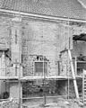
 Achter- en zijgevel nr. CE 7 - Wognum - 20451091 - RCE.jpg 1,200 × 900; 171 KB
-
 Beschilderde torenruimte - Wognum - 20216548 - RCE.jpg 1,193 × 1,200; 348 KB
-
 Beschilderde torenruimte - Wognum - 20216549 - RCE.jpg 1,192 × 1,200; 334 KB
-
 Beschilderde torenruimte - Wognum - 20216550 - RCE.jpg 1,188 × 1,200; 303 KB
-
 Detail beschildering torenruimte - Wognum - 20216551 - RCE.jpg 1,197 × 1,200; 304 KB
-
 Detail beschildering torenruimte - Wognum - 20216552 - RCE.jpg 1,190 × 1,200; 381 KB
-
 Detail doopboog - Wognum - 20216556 - RCE.jpg 1,200 × 960; 194 KB
-
 Detail doopboog - Wognum - 20216557 - RCE.jpg 1,200 × 960; 202 KB
-
 Doopboog - Wognum - 20216558 - RCE.jpg 1,200 × 967; 153 KB
-
 Dorpsgezicht 1959 X-8 AFB.544 PAG.401 - Unknown - 20443411 - RCE.jpg 1,200 × 900; 185 KB
-
 Entree Hervormde kerk, Wognum.JPG 1,944 × 2,592; 1.9 MB
-
 Entree toren Hervormde kerk, Wognum.JPG 1,944 × 2,592; 2.69 MB
-
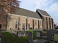
 Exterieur zuidgevel - Wognum - 20216526 - RCE.jpg 1,200 × 960; 337 KB
-
 Gedeelte zuidgevel - Wognum - 20216527 - RCE.jpg 960 × 1,200; 354 KB
-
 Gedenkbord - Wognum - 20216536 - RCE.jpg 1,200 × 946; 334 KB
-
 Gedenkbord - Wognum - 20216537 - RCE.jpg 1,200 × 960; 358 KB
-
 Hervormde kerk, Wognum1.JPG 2,592 × 1,944; 2.22 MB
-
 Hervormde kerk, Wognum2.JPG 2,592 × 1,944; 3.29 MB
-
 I overzicht - Wognum - 20216564 - RCE.jpg 1,200 × 794; 217 KB
-
 Ingang noordzijde - Wognum - 20216535 - RCE.jpg 966 × 1,200; 283 KB
-
 Interieur naar het oosten - Wognum - 20216518 - RCE.jpg 783 × 1,200; 171 KB
-
 Interieur naar het oosten - Wognum - 20216554 - RCE.jpg 960 × 1,200; 220 KB
-
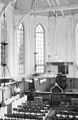
 Interieur naar het westen - Wognum - 20216553 - RCE.jpg 960 × 1,200; 208 KB
-
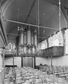
 Interieur richting het orgel - Wognum - 20216517 - RCE.jpg 813 × 1,200; 219 KB
-
 Interieur, aanzicht orgel, orgelnummer 1902 - Wognum - 20417700 - RCE.jpg 875 × 1,200; 190 KB
-
 Interieur, muurschilderingen in de torenruimte - Wognum - 20375119 - RCE.jpg 1,200 × 1,192; 262 KB
-
 Interieur, muurschilderingen in de torenruimte, detail - Wognum - 20375120 - RCE.jpg 1,200 × 1,200; 301 KB
-
 Interieur, muurschilderingen in de torenruimte, detail - Wognum - 20375122 - RCE.jpg 1,199 × 1,200; 285 KB
-
-

-
 Inwendig - Wognum - 20216515 - RCE.jpg 783 × 1,200; 185 KB
-
 Inwendig, cartouche - Wognum - 20216519 - RCE.jpg 1,200 × 945; 210 KB
-
 Inwendig, preekstoel en profil - Wognum - 20216521 - RCE.jpg 1,200 × 971; 197 KB
-
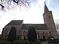
 Kerk en toren - Wognum - 20216523 - RCE.jpg 931 × 1,200; 209 KB
-
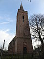
 Kerk vanuit het noord-westen - Wognum - 20216514 - RCE.jpg 768 × 1,200; 162 KB
-
 Kerk vanuit het noord-westen - Wognum - 20216516 - RCE.jpg 957 × 1,200; 188 KB
-
 Koor, oostgevel - Wognum - 20216529 - RCE.jpg 960 × 1,200; 325 KB
-
 Koor, zuidgevel - Wognum - 20216528 - RCE.jpg 960 × 1,200; 296 KB
-
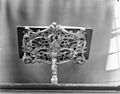 Lezenaar op het doophek - Wognum - 20216522 - RCE.jpg 1,200 × 944; 193 KB
-
 Lezenaar op het doophek - Wognum - 20216525 - RCE.jpg 1,200 × 957; 190 KB
-
 Luidklok - Wognum - 20216547 - RCE.jpg 1,190 × 1,200; 335 KB
-
 Nok en bovendeel Toren vanuit het zuid-oosten - Wognum - 20216520 - RCE.jpg 956 × 1,200; 241 KB
-
 Noordgevel, gevonden venster in vierde travee - Wognum - 20216534 - RCE.jpg 1,200 × 960; 332 KB
-
 Noordgevel, tweede steunbeer vanaf de toren - Wognum - 20216532 - RCE.jpg 960 × 1,200; 325 KB
-
 Noordzijde, eerste travee - Wognum - 20216542 - RCE.jpg 1,190 × 1,200; 336 KB
-
 Noordzijde, toren rechts - Wognum - 20216530 - RCE.jpg 960 × 1,200; 320 KB
-
 Noordzijde, tweede travee - Wognum - 20216531 - RCE.jpg 960 × 1,200; 373 KB
-
 Noordzijde, vierde travee - Wognum - 20216533 - RCE.jpg 1,200 × 960; 348 KB
-
 Oostzijde toren - Wognum - 20216543 - RCE.jpg 1,190 × 1,200; 325 KB
-
 Oostzijde toren - Wognum - 20216544 - RCE.jpg 1,192 × 1,200; 338 KB
-
 Orgel - Wognum - 20216559 - RCE.jpg 968 × 1,200; 219 KB
-
 Preekstoel - Wognum - 20216555 - RCE.jpg 960 × 1,200; 196 KB
-
 Tekstbord - Wognum - 20216560 - RCE.jpg 1,200 × 952; 156 KB
-
 Toren Hervormde kerk, Wognum1.JPG 1,944 × 2,592; 1.78 MB
-
 Toren Hervormde kerk, Wognum2.JPG 1,944 × 2,592; 2.52 MB
-

-
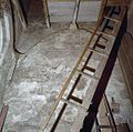
 Toren, aanzet verdwenen gewelf - Wognum - 20216545 - RCE.jpg 1,190 × 1,200; 416 KB
-
 Torenruimte - Wognum - 20357219 - RCE.jpg 1,188 × 1,200; 281 KB
-
 Windvaan, zeemeermin - Wognum - 20216538 - RCE.jpg 1,195 × 1,200; 345 KB
-

-
 Zuidmuur, derde travee, interieur - Wognum - 20216539 - RCE.jpg 1,192 × 1,200; 302 KB
-
 Zuidmuur, venster eerste travee - Wognum - 20216540 - RCE.jpg 1,192 × 1,200; 307 KB
-
 Zuidzijde, eerste travee - Wognum - 20216541 - RCE.jpg 1,188 × 1,200; 312 KB


