Category:Inscription romaine du col de la Forclas
Jump to navigation
Jump to search
| Object location | | View all coordinates using: OpenStreetMap |
|---|
|
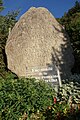
This building is classé au titre des monuments historiques de la France. It is indexed in the base Mérimée, a database of architectural heritage maintained by the French Ministry of Culture, under the reference PA00118436
|
 | |||||
| Upload media | |||||
| Instance of | |||||
|---|---|---|---|---|---|
| Part of |
| ||||
| Location | Passy, canton of Saint-Gervais-les-Bains | ||||
| Heritage designation |
| ||||
 | |||||
Media in category "Inscription romaine du col de la Forclas"
The following 2 files are in this category, out of 2 total.
-
 Borne romaine du col de la Forclas à St Gervais les Bains.jpg 1,880 × 2,852; 4.25 MB
-
 Fac similé de la borne romaine du col de la Forclas à St Gervais les Bains.jpg 2,000 × 3,008; 5.11 MB
