Category:Inverurie
Перейти до навігації
Перейти до пошуку
Български: 300px|мини|Панорамен изглед от Инвърури
Deutsch: Inverurie ist eine Stadt in Aberdeenshire, Schottland mit etwa 10.760 Einwohnern (Schätzung 2004).
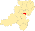
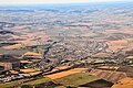
English: Inverurie is a Royal Burgh in Aberdeenshire, Scotland, approximately north west of Aberdeen on the A96 road and is served by Inverurie railway station on the Aberdeen to Inverness Line. The nearest airport is Aberdeen International Airport at Dyce.
Gàidhlig: Is docha gu bheil thu a' lorg Inbhir Aora
Norsk bokmål: Inverurie ( Skotsk gælisk: Inbhir Uraidh) er en by (town) i regionen Aberdeenshire i Skottland. Den har historisk staus som kongelig burgh. Inverurie ligger omtrent 25 kilometer nordvest for Aberdeen.
Scots: Inverurie is a Ryal Burgh in Aiberdeenshire, Scotland, aboot 16 mile nor'wast o Aiberdeen on the A96 road an lees on the "Northern Express Railway Route" frae Aiberdeen tae Innerness. The maist naurhaund airport is Aiberdeen International Airport at Dyce.
Simple English: Inverurie is a Royal Burgh in Aberdeenshire, Scotland, approximately 16 miles north west of Aberdeen on the A96 road and lies on the Northern Express Railway Route from Aberdeen to Inverness. The nearest airport is Aberdeen International Airport at Dyce.
town in Aberdeenshire, Scotland, UK, north of the confluence of the Rivers Don and Urie  | |||||
| Завантажити медіафайл | |||||
| Є одним із |
| ||||
|---|---|---|---|---|---|
| Місце розташування |
| ||||
| Розташовується на водоймі | |||||
| Кількість населення |
| ||||
| офіційний сайт | |||||
 | |||||
Підкатегорії
Показано 9 підкатегорій із 9.
B
- Broomend henge (4 F)
E
- Easter Aquhorthies stone circle (28 F)
H
- Harlaw Monument (7 F)
I
- Inverurie Castle (1 F)
- Inverurie Football Club (4 F)
- Inverurie railway station (7 F)
- Inverurie Town Hall (8 F)
M
- Maiden Stone (35 F)
Файли в категорії «Inverurie»
Показано 60 файлів цієї категорії (із 60).
-
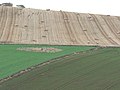 Balquhain Stone Circle - geograph.org.uk - 613456.jpg 640 × 480; 68 КБ
-
 Bilingual fishing sign - geograph.org.uk - 1306767.jpg 640 × 480; 88 КБ
-

-
 Brandsbutt Stone Circle - geograph.org.uk - 844682.jpg 640 × 427; 61 КБ
-
Brandsbutt Stone.ogg 2хв 3с; 1,31 МБ
-
 Flooded quarry - geograph.org.uk - 853878.jpg 640 × 480; 84 КБ
-
 Garioch Rugby Football Club Logo.png 1385 × 791; 4,19 МБ
-
 Inverurie and District.svg 1488 × 1279; 109 КБ
-
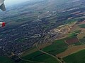 Inverurie birds-eye-view.jpg 3264 × 2448; 1,42 МБ
-
 Inverurie hospital (geograph 6082112).jpg 5607 × 3992; 4,17 МБ
-
 Inverurie, Aberdeenshire (40828970531).jpg 5146 × 3418; 5,64 МБ
-
 Inverurie-Panorama.jpg 640 × 480; 63 КБ
-
 Inverurie.jpg 2214 × 1444; 414 КБ
-
 Martin Sandbank - geograph.org.uk - 957314.jpg 640 × 412; 78 КБ
-
 MeldrumAcademy.jpg 1800 × 1200; 312 КБ
-
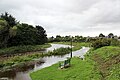
 Mill Race Lock - geograph.org.uk - 1208984.jpg 640 × 480; 152 КБ
-
 Old Mill - geograph.org.uk - 1208991.jpg 640 × 480; 157 КБ
-
 Ordnance Survey One-Inch Sheet 40 Aberdeen, Published 1959.jpg 8220 × 10 003; 10,21 МБ
-
 Ordnance Survey One-Inch Sheet 40 Aberdeen, Published 1969.jpg 8287 × 9857; 34,01 МБ
-
 Ordnance Survey One-Inch Sheet 40 Inverurie & Ellon, Published 1929.jpg 12 108 × 9393; 12,75 МБ
-
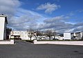
 Redevelopment, Inverurie.jpg 640 × 625; 92 КБ
-
 Road near Craigharr - geograph.org.uk - 768100.jpg 480 × 640; 474 КБ
-
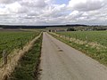
 Road to Inverurie near Craigforthie - geograph.org.uk - 768183.jpg 480 × 640; 430 КБ
-
 Road to Newton of Corsindae - geograph.org.uk - 1339802.jpg 640 × 426; 153 КБ
-
 Road to Peathill Farm - geograph.org.uk - 768024.jpg 640 × 480; 75 КБ
-
 Sewage Works at Inverurie - geograph.org.uk - 740707.jpg 640 × 480; 59 КБ
-
 Sewage Works at Inverurie - geograph.org.uk - 740727.jpg 640 × 480; 74 КБ
-
 Stone Circle at Inverurie - panoramio.jpg 17 597 × 1080; 17,34 МБ
-
 ThainstoneHotel - geograph.org.uk - 28706.jpg 640 × 480; 110 КБ
-
 The Don in flood (geograph 2968856).jpg 640 × 427; 266 КБ
-
 The Paper Mill at Inverurie - geograph.org.uk - 740881.jpg 640 × 480; 69 КБ
-
 The pastoral settong for Midmar fishery. - geograph.org.uk - 486360.jpg 640 × 480; 118 КБ
-
 The River Don - geograph.org.uk - 740471.jpg 640 × 480; 86 КБ
-
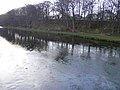
 The River Don at Inverurie - geograph.org.uk - 740587.jpg 640 × 480; 76 КБ
-

-
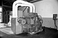 Thomas Tait papermill, steam turbine - geograph.org.uk - 1735104.jpg 640 × 426; 53 КБ
-
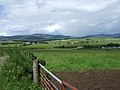
 View from Upper Lurg - geograph.org.uk - 427901.jpg 640 × 480; 81 КБ
-
 Access road to Waterside - geograph.org.uk - 502946.jpg 640 × 426; 109 КБ
-
 Andersons of Inverurie - geograph.org.uk - 1097721.jpg 640 × 333; 166 КБ
-
 B9001 heading north - geograph.org.uk - 591266.jpg 640 × 480; 75 КБ
-
 Bennachie Mount - geograph.org.uk - 844652.jpg 640 × 427; 27 КБ
-
 Bourtie Kirk - geograph.org.uk - 670924.jpg 640 × 480; 97 КБ
-
 Brooms - geograph.org.uk - 739804.jpg 640 × 480; 47 КБ
-
 Climb towards Lumphart Farm - geograph.org.uk - 591277.jpg 640 × 480; 99 КБ
-
 Climbing Tower - geograph.org.uk - 507658.jpg 480 × 640; 68 КБ
-
 Collyhill - geograph.org.uk - 739791.jpg 640 × 480; 77 КБ
-
 End of the Road - geograph.org.uk - 507700.jpg 480 × 640; 88 КБ
-
 Farm track near Bourtie Lodge - geograph.org.uk - 504805.jpg 640 × 480; 97 КБ
-

-
 Invitation to Investigate - geograph.org.uk - 507656.jpg 640 × 480; 99 КБ
-
 Lodge at the north gate of Keith Hall - geograph.org.uk - 498834.jpg 640 × 480; 113 КБ
-
 Middleton Farm road end - geograph.org.uk - 613462.jpg 640 × 480; 60 КБ
-
 Paper Mill Inverurie - geograph.org.uk - 412734.jpg 640 × 480; 54 КБ
-
 Pictish Symbol Stone at Drimmies - geograph.org.uk - 613448.jpg 640 × 480; 125 КБ
-
 Pylons across Dilly Hill - geograph.org.uk - 613472.jpg 640 × 480; 65 КБ
-
 River Don, Inverurie - geograph.org.uk - 413729.jpg 640 × 480; 69 КБ
-
 Thainstone Agricultural Centre - geograph.org.uk - 507672.jpg 640 × 453; 66 КБ
-
 Thainstone Centre - geograph.org.uk - 507663.jpg 640 × 480; 72 КБ
-
 Thainstone Home Farm - geograph.org.uk - 507712.jpg 640 × 480; 89 КБ
-
 Thomas Tait paper mill, Inverurie - geograph.org.uk - 478350.jpg 640 × 377; 37 КБ


.jpg)
.jpg)


.jpg)


