Category:Kirche Arnsdorf (Vierkirchen)
Jump to navigation
Jump to search
| Object location | | View all coordinates using: OpenStreetMap |
|---|
church building in Vierkirchen, Saxony, Germany  | |||||
| Upload media | |||||
| Instance of | |||||
|---|---|---|---|---|---|
| Location | Q697457, Vierkirchen, Görlitz, Saxony, Germany | ||||
| Street address |
| ||||
| Heritage designation | |||||
| Inception |
| ||||
 | |||||
| (Wikidata) |
Subcategories
This category has only the following subcategory.
Media in category "Kirche Arnsdorf (Vierkirchen)"
The following 16 files are in this category, out of 16 total.
-
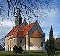
 20070519310MDR Arnsdorf (Vierkirchen) Kirche St Katharinen.jpg 2,457 × 2,790; 5.85 MB
-
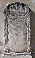 20070519330DR Arnsdorf (Vierkirchen) Kirche St Katharinen Epitaph.jpg 1,454 × 2,432; 3.6 MB
-
 Arnsdorf Steinkreuz I.jpg 2,736 × 3,648; 3.31 MB
-
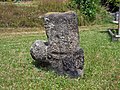 Arnsdorf Steinkreuz II.jpg 3,648 × 2,736; 4.32 MB
-
 Vierkirchen Arnsdorf - Kirche 01 ies.jpg 5,616 × 3,744; 18.79 MB
-
 Vierkirchen Arnsdorf - Kirche 02 ies.jpg 5,616 × 3,744; 17.11 MB
-
 Vierkirchen Arnsdorf - Kirche 03 ies.jpg 5,616 × 3,744; 15.58 MB
-
 Vierkirchen Arnsdorf - Kirche 04 ies.jpg 3,744 × 5,616; 15.06 MB
-
 Vierkirchen Arnsdorf - Kirche 05 ies.jpg 5,616 × 3,744; 10.59 MB
-
 Vierkirchen Arnsdorf - Kirche 06 ies.jpg 5,616 × 3,744; 14.53 MB
-
 Vierkirchen Arnsdorf - Kirche 07 ies.jpg 5,616 × 3,744; 15.03 MB
-
 Vierkirchen Arnsdorf - Kirche 08 ies.jpg 3,744 × 5,616; 13.35 MB
-
 Vierkirchen Arnsdorf - Kirche 09 ies.jpg 5,616 × 3,744; 14.28 MB
-
 Vierkirchen Arnsdorf Kirche 1.jpg 2,007 × 1,505; 1.13 MB
-
 Vierkirchen Arnsdorf Kirche.jpg 1,736 × 1,599; 1.12 MB
-
 Vierkirchen Arnsdorf Pfarrhaus.jpg 3,648 × 2,736; 3.1 MB
_Kirche_St_Katharinen.jpg)
_Kirche_St_Katharinen_Epitaph.jpg)


