Category:Kramerzunft (Memmingen)
Jump to navigation
Jump to search
| Object location | | View all coordinates using: OpenStreetMap |
|---|
building in Memmingen, Germany  | |||||
| Upload media | |||||
| Instance of | |||||
|---|---|---|---|---|---|
| Location | Memmingen, Swabia, Bavaria, Germany | ||||
| Street address |
| ||||
| Heritage designation | |||||
 | |||||
This is the category of the Bavarian Baudenkmal (cultural heritage monument) with the ID D-7-64-000-251 (Wikidata)
|
Media in category "Kramerzunft (Memmingen)"
The following 23 files are in this category, out of 23 total.
-
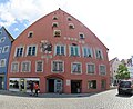
 Das Kramerzunfthaus.jpg 2,551 × 1,701; 1.12 MB
-
 Die zwölf Artikel - panoramio.jpg 2,816 × 2,120; 1.45 MB
-
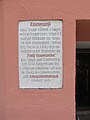 KZ-MM-Nord-Geschichtstafel.jpg 3,888 × 5,184; 4.04 MB
-
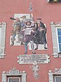 KZ-MM-Nord-Malerei.jpg 3,888 × 5,184; 4.41 MB
-
 KZ-MM-Nord-Pan.jpg 4,394 × 3,575; 9.73 MB
-
 KZ-MM-Nord.jpg 5,184 × 3,888; 5.81 MB
-
 KZ-MM-Ost-OdD-nah.jpg 5,184 × 3,888; 4.61 MB
-
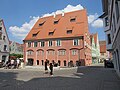 KZ-MM-Suedwest.jpg 5,184 × 3,888; 5.11 MB
-
 KZ-MM-West-fern.jpg 5,184 × 3,888; 5.62 MB
-
 KZ-MM-West-Mittel.jpg 5,184 × 3,888; 6.43 MB
-
 KZ-MM-West-nah-OdD.jpg 3,888 × 5,184; 4.48 MB
-
 KZ-MM-West-nah.jpg 5,184 × 3,888; 5.28 MB
-
 KZ-MM-West-OdD.jpg 5,184 × 3,888; 5.18 MB
-
 KZ-MM-West.jpg 5,184 × 3,888; 5.63 MB
-
 Malerei Kraemerzunft Memmingen.JPG 1,920 × 2,560; 2.9 MB
-
 Memmingen, Geschichtstafel Kramerzunft, 1.jpeg 3,200 × 4,800; 5.45 MB
-
 Memmingen, Kramerzunft, Bild 12 Artikel, 6.jpeg 3,200 × 5,200; 7.15 MB
-
 Memmingen-kramerzunft-12-artikel.JPG 3,264 × 2,448; 1.35 MB
-
 MM-SWeinm05.jpg 784 × 1,024; 941 KB
-
 Weinmarkt 15 Memmingen-1.jpg 3,647 × 4,984; 2.01 MB
-
 Weinmarkt 15 Memmingen-2.jpg 5,472 × 3,648; 2.55 MB
-
 Weinmarkt 15 Memmingen-3.jpg 3,647 × 5,327; 1.96 MB
-
 ZwölfArtikelHaus.jpg 3,888 × 2,592; 738 KB


