Category:Landkreis Fulda
Prijeđi na navigaciju
Prijeđi na pretraživanje
rural district of Hesse:
Bergstraße · Darmstadt-Dieburg · Fulda · Gießen (okrug) · Groß-Gerau · Hersfeld-Rotenburg · Hochtaunuskreis · Lahn-Dill-Kreis · Landkreis Kassel · Limburg-Weilburg · Main-Kinzig-Kreis · Main-Taunus-Kreis · Marburg-Biedenkopf · Odenwaldkreis · Offenbach · Rheingau-Taunus-Kreis · Schwalm-Eder-Kreis · Vogelsbergkreis · Waldeck-Frankenberg · Werra-Meißner-Kreis · Wetteraukreis
urban district of Hesse:
district in Hesse, Germany    | |||||
| Postavi datoteku | |||||
| Jest | |||||
|---|---|---|---|---|---|
| Nazvano po | |||||
| Lokacija | Kassel Government Region, Hessen, Njemačka | ||||
| Glavni grad | |||||
| Stanovništvo |
| ||||
| Površina |
| ||||
| Nadmorska visina |
| ||||
| službena mrežna stranica | |||||
 | |||||
Français : L'arrondissement de Fulda est un arrondissement de Hesse situé dans le district de Cassel. Son chef lieu est Fulda.
Potkategorije
Ova kategorija ima sljedeće 24 potkategorije, od ukupno 24.
B
- Boundary stones in Fulda (12 F)
- Bus stops in Landkreis Fulda (43 F)
F
- Aerial photographs of Fulda (17 F)
M
P
R
S
- Schools in Landkreis Fulda (2 F)
Mediji u kategoriji »Landkreis Fulda«
Prikazano je 37 datoteka u ovoj kategoriji, od njih ukupno 37.
-
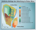 Abtorfung Rotes Moor.png 1.967 × 1.626; 241 KB
-
 Ausschnitt Landkarte Hochstift Fulda von Regerwill 1574.jpg 800 × 581; 312 KB
-
 Herbst I (48993650).jpeg 2.048 × 1.365; 252 KB
-
 Herbst Ii (48993606).jpeg 2.048 × 1.365; 167 KB
-
 KFZ-Zulassungsplakette des Landkreises Fulda-neu.JPG 1.168 × 1.144; 258 KB
-
 North of Fulda 2019-07-14 01.jpg 5.184 × 3.888; 8,1 MB
-
 North of Fulda 2019-07-14 02.jpg 5.184 × 3.888; 8,12 MB
-
 North of Fulda 2019-07-14 03.jpg 5.184 × 3.888; 8,86 MB
-
 North of Fulda 2019-07-14 04.jpg 5.184 × 3.888; 9,3 MB
-
 North of Fulda 2019-07-14 05.jpg 5.184 × 3.888; 9,35 MB
-
 North of Fulda 2019-07-14 06.jpg 5.184 × 3.888; 10,01 MB
-
 North of Fulda 2019-07-14 07.jpg 5.184 × 3.888; 8,4 MB
-
 North of Fulda 2019-07-14 08.jpg 5.184 × 3.888; 9,67 MB
-
 North of Fulda 2019-07-14 09.jpg 5.184 × 3.888; 8,1 MB
-
 North of Fulda 2019-07-14 10.jpg 5.184 × 3.888; 9,37 MB
-
 North of Fulda 2019-07-14 11.jpg 5.184 × 3.888; 10 MB
-
 North of Fulda 2019-07-14 12.jpg 5.184 × 3.888; 10,32 MB
-
 North of Fulda 2019-07-14 13.jpg 5.184 × 3.888; 10,25 MB
-
 North of Fulda 2019-07-14 14.jpg 5.184 × 3.888; 10,49 MB
-
 North of Fulda 2019-07-14 15.jpg 5.184 × 3.888; 9,93 MB
-
 North of Fulda 2019-07-14 16.jpg 5.184 × 3.888; 9,7 MB
-
 North of Fulda 2019-07-14 17.jpg 5.184 × 3.888; 9,73 MB
-
 North of Fulda 2019-07-14 18.jpg 5.184 × 3.888; 10,25 MB
-
 North of Fulda 2019-07-14 19.jpg 5.184 × 3.888; 10,38 MB
-
 North of Fulda 2019-07-14 20.jpg 5.184 × 3.888; 10,12 MB
-
 North of Fulda 2019-07-14 21.jpg 5.184 × 3.888; 9,82 MB
-
 North of Fulda 2019-07-14 22.jpg 5.184 × 3.888; 9,54 MB
-
 Pantherspanner auf Schlangenknöterich II.jpg 5.184 × 3.456; 5,77 MB
-
 Rhön (259724251).jpeg 1.365 × 2.048; 1.003 KB
-
 Rothenmoor.jpg 1.129 × 1.477; 621 KB
-
 Schmutzbedeckte Blätter Ende April 2018.jpg 3.888 × 2.592; 5,72 MB
-
 Schnitte 1800 Rotes Moor.png 1.967 × 1.626; 227 KB
-
 Wait For Me (259723107).jpeg 2.048 × 1.365; 639 KB
-
 Waldentwicklung Rotes Mohr.png 1.915 × 1.508; 161 KB
-
 Warttürme im Landkreis Fulda.jpg 2.266 × 2.915; 742 KB
-
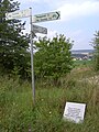 Wegweiser und Tafel im "Rhöner Platt" nähe Leimbach.JPG 2.736 × 3.648; 5,5 MB
-
 Westlichster Punkt des Landkreises Fulda in Jossa.jpg 3.072 × 2.304; 3,72 MB


.jpeg)
.jpeg)


.jpeg)


.jpeg)


