Category:Lundin Links
Jump to navigation
Jump to search

Deutsch: Lundin Links ist ein Teil der kleine schottische Ortschaft Lundis auf der Nordseite des Firth of Forth in der Grafschaft Fife. Die bedeutendste Sehenswürdigkeit, die Menhire von Lundin Links, stehen westlich von Lundin auf dem Gelände des örtlichen Ladies Golf Club.
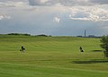
English: Lundin Links is a small village in Fife, Scotland. The village is best known for its two golf courses. The 18 hole course, Lundin Golf Club, was used as a pre-qualifying course when The Open Championship is held at St. Andrews. Lundin Links Ladies 9 hole course is the oldest woman's golf course in the world.
village in Fife, Scotland, UK  | |||||
| Upload media | |||||
| Instance of | |||||
|---|---|---|---|---|---|
| Location |
| ||||
 | |||||
Subcategories
This category has the following 3 subcategories, out of 3 total.
L
- Lundin Links beach (5 F)
- Lundin Tower (5 F)
Media in category "Lundin Links"
The following 48 files are in this category, out of 48 total.
-
 566638-lundin-links-sunlounge-conservatory.jpg 1,400 × 932; 878 KB
-
 A burn crosses Lundin Links beach - geograph.org.uk - 3392658.jpg 1,600 × 1,200; 877 KB
-
 A crop near Little Pilmuir - geograph.org.uk - 1366645.jpg 640 × 480; 93 KB
-
 A Sandy Beach - geograph.org.uk - 4589783.jpg 1,600 × 1,200; 405 KB
-
 Basalt on the beach - geograph.org.uk - 2993660.jpg 2,048 × 1,536; 779 KB
-
 By Hatton Farm - geograph.org.uk - 103408.jpg 640 × 480; 203 KB
-
 Carrot crop at Lundin Links - geograph.org.uk - 1366918.jpg 640 × 480; 105 KB
-
 Carrots and wheat at Lundin - geograph.org.uk - 1366896.jpg 640 × 480; 93 KB
-
 Emsdorf Street - geograph.org.uk - 727432.jpg 640 × 432; 69 KB
-
 Field of wheat near Pilmuir - geograph.org.uk - 1368874.jpg 640 × 480; 66 KB
-
 Fife Coast Path, Lundin Links - geograph.org.uk - 1537660.jpg 640 × 480; 103 KB
-
 Golf Clubhouse - geograph.org.uk - 1144396.jpg 640 × 480; 59 KB
-
 Golf, Lundin Links - geograph.org.uk - 788878.jpg 640 × 439; 128 KB
-
 Largo Bay - geograph.org.uk - 3018521.jpg 800 × 530; 355 KB
-
 Largo Bay, Fife - geograph.org.uk - 5498016.jpg 1,069 × 710; 109 KB
-
 Leven beach - geograph.org.uk - 4539023.jpg 1,142 × 857; 684 KB
-
 Links Road, Lundin Links - geograph.org.uk - 788843.jpg 640 × 413; 87 KB
-
 Links Road, Lundin Links - geograph.org.uk - 788860.jpg 640 × 426; 130 KB
-
 Looking towards Pilmuir Farm - geograph.org.uk - 1368878.jpg 640 × 480; 74 KB
-
 Lower Largo direction - geograph.org.uk - 4539019.jpg 1,142 × 857; 581 KB
-
 Lundin Links - geograph.org.uk - 15038.jpg 640 × 459; 39 KB
-
 Lundin Links - geograph.org.uk - 788848.jpg 640 × 426; 89 KB
-
 Lundin Links - geograph.org.uk - 788852.jpg 640 × 426; 84 KB
-
 Lundin Links - geograph.org.uk - 788874.jpg 640 × 426; 61 KB
-
 Lundin Links beach - geograph.org.uk - 2805944.jpg 2,048 × 1,536; 724 KB
-
 Lundin Links Beach - geograph.org.uk - 2919330.jpg 2,520 × 1,680; 344 KB
-
 Lundin Links Hotel - geograph.org.uk - 98624.jpg 640 × 480; 137 KB
-
 Lundin Links station site geograph-3766982-by-Ben-Brooksbank.jpg 2,394 × 1,409; 3.18 MB
-
 Lundin Links with Largo Law above - geograph.org.uk - 2899335.jpg 1,600 × 1,200; 546 KB
-
 Minor road heading for the A915 - geograph.org.uk - 1368870.jpg 640 × 480; 89 KB
-
 Off Links Road - geograph.org.uk - 788854.jpg 640 × 362; 80 KB
-
 On reflection - geograph.org.uk - 396708.jpg 640 × 480; 180 KB
-
 Relics of WWII - geograph.org.uk - 2805936.jpg 1,601 × 1,049; 386 KB
-
 Road to Thomsford Farm - geograph.org.uk - 1368881.jpg 640 × 480; 53 KB
-
 Sands at Leven - geograph.org.uk - 4589764.jpg 1,600 × 1,200; 304 KB
-
 Sandy section of the coastal path - geograph.org.uk - 1144225.jpg 640 × 480; 98 KB
-
 SW across the beach - geograph.org.uk - 4539017.jpg 1,142 × 857; 624 KB
-
 The beach at Largo Bay - geograph.org.uk - 6226214.jpg 800 × 485; 80 KB
-
 The road to Pilmuir - geograph.org.uk - 1366902.jpg 640 × 480; 81 KB
-
 Thomsford bridge - geograph.org.uk - 98569.jpg 640 × 452; 146 KB
-
 Thomsford cottages - geograph.org.uk - 111771.jpg 640 × 480; 96 KB
-
 Towards Largo - geograph.org.uk - 547190.jpg 640 × 417; 71 KB
-
 Towards Little Pilmuir - geograph.org.uk - 98558.jpg 640 × 456; 114 KB
-
 Walled Garden, Silverburn - geograph.org.uk - 15042.jpg 640 × 480; 115 KB
-
 Water Hazard - geograph.org.uk - 400757.jpg 640 × 480; 88 KB
-
 Wheat to the left, oats to the right - geograph.org.uk - 1366925.jpg 640 × 480; 88 KB
-

-
 Woodland, Silverburn - geograph.org.uk - 15044.jpg 640 × 480; 144 KB


