Category:Maps of Vlist
Jump to navigation
Jump to search
Wikimedia category | |||||
| Upload media | |||||
| Instance of | |||||
|---|---|---|---|---|---|
| Category combines topics | |||||
| Vlist | |||||
former Dutch municipality   .svg) | |||||
| Pronunciation audio | |||||
| Instance of |
| ||||
| Location | South Holland, Netherlands | ||||
| Inception |
| ||||
| Dissolved, abolished or demolished date |
| ||||
| Population |
| ||||
| Elevation above sea level |
| ||||
| Replaced by | |||||
| official website | |||||
 | |||||
Subcategories
This category has only the following subcategory.
L
Media in category "Maps of Vlist"
The following 18 files are in this category, out of 18 total.
-
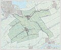
 2013-Vlist.jpg 2,244 × 1,940; 3.39 MB
-
 BAG woonplaatsen - Gemeente Vlist.png 2,419 × 2,419; 531 KB
-
 Gem-Vlist-2014Q1.jpg 4,380 × 3,569; 9.53 MB
-
 Gem-Vlist-OpenTopo.jpg 4,372 × 3,561; 13.07 MB
-
 Map - NL - Vlist (2009).svg 625 × 575; 1.61 MB
-
 Map NL - Vlist - Beneden-Haastrecht.png 800 × 600; 13 KB
-
 Map NL - Vlist - Benedenheul.png 800 × 600; 13 KB
-
 Map NL - Vlist - Benedenkerk.png 800 × 600; 13 KB
-
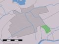 Map NL - Vlist - Bonrepas.png 800 × 600; 13 KB
-
 Map NL - Vlist - Boven-Haastrecht.png 800 × 600; 13 KB
-
 Map NL - Vlist - Bovenkerk.png 800 × 600; 13 KB
-
 Map NL - Vlist - Goudseweg.png 800 × 600; 13 KB
-
 Map NL - Vlist - Het Beijersche.png 800 × 600; 13 KB
-
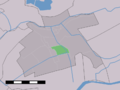
 Map NL - Vlist - Koolwijk.png 800 × 600; 13 KB
-
 Map NL - Vlist - Rozendaal.png 800 × 600; 13 KB
-
 Map NL - Vlist - Schoonouwen.png 800 × 600; 13 KB
-
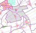
 Map NL - Vlist - Vlist.png 800 × 600; 13 KB
-
 Vlist 1868.png 1,599 × 1,387; 124 KB


.svg)


