Category:Maps of islands of New Zealand
Jump to navigation
Jump to search
Subcategories
This category has the following 10 subcategories, out of 10 total.
Media in category "Maps of islands of New Zealand"
The following 25 files are in this category, out of 25 total.
-
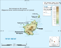
 Topographical map of the Antipodes Islands in English.svg 1,242 × 980; 164 KB
-
 Topographical map of the Antipodes Islands in Macedonian.svg 1,242 × 980; 164 KB
-
 Neuseeland mit Auckland Inseln.png 365 × 522; 61 KB
-
 Auckland Islands New Zealand geographic map en.svg 1,800 × 2,274; 2.37 MB
-
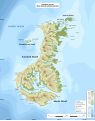
 Auckland islands topo.png 1,133 × 1,507; 867 KB
-
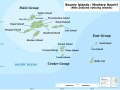
 Bounty Islands map.png 480 × 401; 34 KB
-
 Bounty Islands New Zealand geographic map en.svg 2,420 × 1,800; 102 KB
-
 Neuseeland mit Campbell.png 329 × 484; 55 KB
-
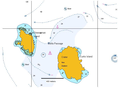
 Campbell Island map.png 800 × 743; 103 KB
-
 Campbell Island New Zealand geographic map en.svg 1,005 × 1,000; 755 KB
-
 Cook Islands (New Zealand) map.png 324 × 348; 15 KB
-
 CurtisM.png 700 × 530; 194 KB
-
 Hypolepis Distribution.jpg 608 × 860; 48 KB
-
 Karta NZ Kermadec isl.PNG 300 × 500; 3 KB
-
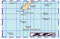
 Kermadec islands.jpg 635 × 468; 95 KB
-
 NZOffshoreIslandsMap-he.png 911 × 581; 102 KB
-
 NZOffshoreIslandsMap.png 911 × 581; 76 KB
-
 Pig-island-lake-wakatipu.png 235 × 438; 20 KB
-
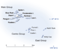
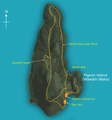 Pigeon Island (New Zealand) with details - 01.png 1,293 × 1,385; 320 KB
-
 Pigeon-island-lake-wakatipu.png 222 × 406; 21 KB
-
 SnaresInseln.jpg 562 × 295; 29 KB
-
 Snares Islands New Zealand geographic map en.svg 2,751 × 1,800; 195 KB
-
 Solander Islands New Zealand geographic map en.svg 2,851 × 1,800; 91 KB
-
 Three Kings Islands New Zealand geographic map en.svg 1,765 × 1,000; 944 KB
-
 Wakatipu Island Map.svg 595 × 842; 1.04 MB


_map.png)


_with_details_-_01.png)


