Category:Maps of the Dutch East India Company - Japan
Jump to navigation
Jump to search
Media in category "Maps of the Dutch East India Company - Japan"
The following 13 files are in this category, out of 13 total.
-
 AMH-5167-NA Map of the east coast of China and several Japanese islands.jpg 2,400 × 1,692; 422 KB
-
-
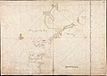
 AMH-5177-NA Map of Japan, Korea and west America.jpg 2,400 × 1,693; 455 KB
-
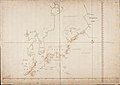
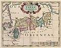
 AMH-5178-NA Map of Japan.jpg 2,400 × 1,700; 481 KB
-
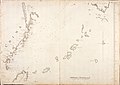
 AMH-5182-NA Map of the islands of Japan to Halmaheira.jpg 2,400 × 1,720; 400 KB
-
 AMH-5191-NA Map of the Cape of Good Hope up to and including Japan.jpg 2,400 × 1,724; 787 KB
-
 AMH-5650-KB Map of Japan.jpg 2,400 × 1,803; 449 KB
-
 AMH-5651-KB Map of Japan.jpg 2,400 × 1,915; 822 KB
-
 AMH-6666-KB Map of Japan.jpg 2,400 × 1,872; 907 KB
-
 AMH-6816-KB Map of Japan.jpg 2,400 × 1,627; 811 KB
-
 AMH-7930-KB Map of Japan, China and Korea.jpg 2,400 × 1,815; 837 KB
-
 AMH-8025-KB Map of Japan.jpg 2,400 × 1,768; 909 KB
-
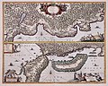
 AMH-8129-KB Map of part of Japan, China and Formosa.jpg 2,400 × 2,077; 680 KB


