Category:Meigh
Jump to navigation
Jump to search
English: Meigh is a small village in County Armagh, Northern Ireland. It had a population of 444 people in the 2001 Census. It lies within the Newry and Mourne District Council area.
village in United Kingdom  | |||||
| Upload media | |||||
| Instance of | |||||
|---|---|---|---|---|---|
| Location | Northern Ireland | ||||
 | |||||
Media in category "Meigh"
The following 174 files are in this category, out of 174 total.
-
 'No Mast Here' - geograph.org.uk - 6065010.jpg 1,334 × 1,780; 1.35 MB
-

-
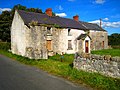
 A delightful thatched cottage on the Low Road, Meigh - geograph.org.uk - 4367183.jpg 1,600 × 1,188; 559 KB
-
 A section of the left bank tributary of the Flurry River - geograph.org.uk - 6065450.jpg 4,000 × 3,000; 2.77 MB
-
 A Tricolour at the eastern entrance to Meigh - geograph.org.uk - 3016201.jpg 720 × 1,024; 123 KB
-
 Abandoned House, near Slieve Gullion - geograph.org.uk - 564077.jpg 640 × 480; 103 KB
-
 Agricultural merchants on Railway Road, Meigh - geograph.org.uk - 4368163.jpg 1,600 × 1,199; 410 KB
-

-
 Approaching Meigh Cross Roads along Chapel Road - geograph.org.uk - 3927527.jpg 1,024 × 697; 114 KB
-

-

-
 Approaching Meigh Crossroads from the West - geograph.org.uk - 5963765.jpg 3,127 × 2,108; 3.02 MB
-
 Approaching Meigh Level Crossing from the south - geograph.org.uk - 4367469.jpg 1,600 × 1,000; 335 KB
-
 Approaching the junction with the B113 along Wood Road - geograph.org.uk - 6063918.jpg 2,668 × 2,000; 4.11 MB
-
 Approaching the Low Road Bridge over the Flurry River - geograph.org.uk - 4370781.jpg 1,600 × 1,200; 682 KB
-
 Approaching the Railway Road Level Crossing at Meigh - geograph.org.uk - 6060404.jpg 2,630 × 1,533; 1.89 MB
-
 B113 (Drumintee Road), Meigh - geograph.org.uk - 5963759.jpg 3,311 × 1,998; 3.45 MB
-
 Bearna Park Estate, Meigh - geograph.org.uk - 3452536.jpg 1,024 × 707; 133 KB
-
 Bench, Slieve Gullion Forest Park - geograph.org.uk - 563960.jpg 640 × 480; 138 KB
-
 Bernea Park Estate, Meigh - geograph.org.uk - 3568503.jpg 1,024 × 748; 122 KB
-

-
 Building at Slieve Gullion forest park - geograph.org.uk - 538046.jpg 640 × 480; 189 KB
-
 Bungalows in Kilgen Drive, Meigh - geograph.org.uk - 3927611.jpg 1,024 × 493; 110 KB
-
 Bungalows on Lower Newtown Road - geograph.org.uk - 4370916.jpg 1,600 × 1,200; 575 KB
-

-

-

-
 Car park at Slieve Gullion - geograph.org.uk - 538060.jpg 640 × 480; 119 KB
-

-
 Cattle, near Slieve Gullion - geograph.org.uk - 564084.jpg 640 × 480; 108 KB
-

-
 Clonlum South Cairn - geograph.org.uk - 564069.jpg 640 × 480; 93 KB
-
 Cottage near Meigh - geograph.org.uk - 443786.jpg 640 × 480; 87 KB
-

-

-
 Crossroads south-east of the Railway Road Level Crossing - geograph.org.uk - 6065536.jpg 2,965 × 2,000; 4.7 MB
-

-
 Derelict homestead on the east side of Railway Road, Meigh - geograph.org.uk - 6065488.jpg 3,759 × 1,762; 3.35 MB
-
 Disused homestead on Railway Road - geograph.org.uk - 4370575.jpg 1,600 × 1,200; 506 KB
-
 Entering Meigh along the Forkhill Road - geograph.org.uk - 3567749.jpg 1,024 × 722; 133 KB
-
 Entering Meigh from the north along Chapel Road - geograph.org.uk - 3928597.jpg 1,024 × 768; 153 KB
-
 Entering Meigh from the West along the B113 (Forkhill Road) - geograph.org.uk - 6062463.jpg 2,332 × 1,221; 1.43 MB
-
 Entering Meigh on the B113 (Forkill Road) - geograph.org.uk - 5757469.jpg 2,013 × 1,378; 1.4 MB
-

-
 Entrance from the B113 to Cúirt na Cluana at Meigh - geograph.org.uk - 6062363.jpg 4,000 × 3,000; 2.44 MB
-
 Entrance into the Bearna Park Housing Estate - geograph.org.uk - 6062117.jpg 3,805 × 1,738; 2.79 MB
-

-
 Fallen Tree, Slieve Gullion Forest Park - geograph.org.uk - 563964.jpg 640 × 480; 160 KB
-
 Farm buildings on Carn Hill - geograph.org.uk - 446772.jpg 640 × 480; 73 KB
-

-
 Farmland in the Flurry River Valley - geograph.org.uk - 3507274.jpg 1,024 × 768; 124 KB
-
 Fields, East of Slieve Gullion - geograph.org.uk - 564081.jpg 640 × 480; 77 KB
-
 Flat landscape in the Meigh area - geograph.org.uk - 4370593.jpg 1,600 × 1,200; 498 KB
-
 Flurry River below the Low Road Bridge - geograph.org.uk - 4370774.jpg 1,600 × 1,200; 917 KB
-

-
 Former homestead on the Lower Foughill Road - geograph.org.uk - 6079088.jpg 3,589 × 2,511; 5.35 MB
-
 Gate and stile - geograph.org.uk - 538056.jpg 640 × 426; 156 KB
-
 GP Surgery at Meigh - geograph.org.uk - 3016161.jpg 1,024 × 755; 196 KB
-
 Heading for Newry along the B113 - geograph.org.uk - 4368386.jpg 1,600 × 1,198; 324 KB
-
 Houses at the lower end of Low Road - geograph.org.uk - 4370790.jpg 1,600 × 889; 413 KB
-
 Houses in Gullion Way - geograph.org.uk - 3568510.jpg 1,024 × 768; 137 KB
-
 Houses on Seefin Road viewed from the chapel - geograph.org.uk - 3928591.jpg 1,024 × 766; 156 KB
-
 Houses on the B113 (Forkhill Road) at Meigh - geograph.org.uk - 6062121.jpg 3,571 × 2,000; 2.87 MB
-
 Ionad Pobaill na Maighe - Meigh Community Centre - geograph.org.uk - 6062455.jpg 3,969 × 2,124; 4.14 MB
-
 Irish M1 under construction - geograph.org.uk - 446120.jpg 640 × 480; 72 KB
-
 Johnny Murphy's Bar at Meigh Crossroads - geograph.org.uk - 6156449.jpg 2,216 × 1,669; 2.34 MB
-
 Johnny Murphy's Bay and Restaurant at Meigh Cross Roads - geograph.org.uk - 6062138.jpg 3,438 × 1,998; 3.27 MB
-
 Killevy Castle - geograph.org.uk - 564025 (cropped).jpg 520 × 341; 60 KB
-
 Killevy Castle - geograph.org.uk - 564025.jpg 640 × 480; 100 KB
-

-

-

-

-

-
 Lowered barriers at the Railway Road Level Crossing, Meigh - geograph.org.uk - 6065187.jpg 3,335 × 2,545; 4.11 MB
-
 Mackin's Animal Feed Mill on Railway Road, Meigh - geograph.org.uk - 6060336.jpg 4,000 × 3,000; 2.25 MB
-
 Mackin's Animal Food Mill from the southbank of the river - geograph.org.uk - 6065461.jpg 3,740 × 1,954; 3.84 MB
-

-
 Meigh Chapel - geograph.org.uk - 3927129.jpg 1,024 × 751; 133 KB
-
 Meigh Pharmacy - geograph.org.uk - 5757475.jpg 3,840 × 1,880; 3.24 MB
-
 Meigh Pharmacy - geograph.org.uk - 6062113.jpg 3,372 × 2,000; 2.69 MB
-
 Meigh Shopping Centre - geograph.org.uk - 3927508.jpg 1,024 × 615; 100 KB
-
 Meigh village - geograph.org.uk - 773194.jpg 640 × 480; 66 KB
-
 Meigh Village Centre - geograph.org.uk - 257060.jpg 640 × 460; 96 KB
-
 Meigh Waste Water Treatment Plant - geograph.org.uk - 6060830.jpg 4,000 × 3,000; 2.92 MB
-
 Meigh Waste Water Treatment Works - geograph.org.uk - 4368113.jpg 1,600 × 1,200; 478 KB
-
 Meigh's Telephone Exchange - geograph.org.uk - 3927550.jpg 1,024 × 754; 121 KB
-

-
 New houses at Adavoyle - geograph.org.uk - 538030.jpg 640 × 480; 130 KB
-
 New houses on the eastern outskirts of Meigh - geograph.org.uk - 3567959.jpg 1,024 × 635; 131 KB
-
 New houses on the eastern outskirts of Meigh - geograph.org.uk - 5759817.jpg 3,010 × 1,152; 1.98 MB
-

-
 Outbuildings off Railway Road, Meigh - geograph.org.uk - 4370555.jpg 1,004 × 817; 582 KB
-
 Pond at Slieve Gullion forest park - geograph.org.uk - 538052.jpg 640 × 480; 199 KB
-

-

-

-

-

-
 Railway Road, Meigh - geograph.org.uk - 6229943.jpg 3,491 × 2,118; 3.68 MB
-
 Recently built houses along Lower Foughill Road - geograph.org.uk - 6078850.jpg 3,686 × 2,000; 4.61 MB
-
 Reedy land east of Railway Road, Meigh - geograph.org.uk - 6065509.jpg 4,000 × 3,000; 2.68 MB
-

-
 Resting in the shadow of Slieve Gullion - geograph.org.uk - 6080244.jpg 3,823 × 2,509; 6.67 MB
-
 Rural industry near Meigh - geograph.org.uk - 446775.jpg 640 × 480; 54 KB
-

-
 Shopping piazza in the centre of Meigh - geograph.org.uk - 3452568.jpg 1,024 × 725; 136 KB
-

-
 St Joseph's Chapel from the south-west - geograph.org.uk - 3934862.jpg 1,024 × 765; 163 KB
-
 St Joseph's Primary School, Meigh - geograph.org.uk - 3927615.jpg 1,024 × 569; 106 KB
-

-

-
 Station Road descending towards Adavoyle Bridge - geograph.org.uk - 6064757.jpg 2,668 × 2,000; 2.54 MB
-
 SVG Marble and Granites, Low Road, Meigh - geograph.org.uk - 4369793.jpg 1,600 × 1,200; 452 KB
-
 Teac Mallon - Slieve Gullion Art Centre, Meigh - geograph.org.uk - 3927595.jpg 1,024 × 569; 108 KB
-
 Telecommunications mast off Railway Road, Meigh - geograph.org.uk - 6065006.jpg 4,000 × 3,000; 2.21 MB
-
 Thatched cottage on Low Road, Meigh - geograph.org.uk - 4369766.jpg 1,600 × 1,200; 705 KB
-
 Thatched cottage on the Low Road, Meigh - geograph.org.uk - 6229980.jpg 3,164 × 1,998; 3.46 MB
-
 The "Enterprise", Meigh (1984) - geograph.org.uk - 3789673.jpg 640 × 382; 69 KB
-

-

-

-
 The derelict St Luke's CoI Church, Killeavy, Meigh - geograph.org.uk - 6080205.jpg 2,669 × 2,000; 4.84 MB
-
 The Dublin to Belfast Railway North of Adavoyle Bridge - geograph.org.uk - 6062696.jpg 4,000 × 3,000; 2.82 MB
-

-

-
 The Foxall and Seaver Vaults at St Luke's CoI, Killeavy - geograph.org.uk - 6080253.jpg 3,881 × 2,049; 5.9 MB
-
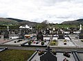 The graveyard at St Joseph's Chapel, Meigh - geograph.org.uk - 3928262.jpg 1,024 × 756; 184 KB
-
 The headwaters of a left bank tributary of the Flurry River - geograph.org.uk - 6065441.jpg 4,000 × 3,000; 2.78 MB
-

-

-
 The lower end of Ballintemple Road at Killeavy - geograph.org.uk - 3507277.jpg 1,024 × 748; 209 KB
-
 The lower end of Chapel Road at Meigh - geograph.org.uk - 3927538.jpg 1,024 × 767; 117 KB
-
 The main altar at St Joseph's Church, Meigh - geograph.org.uk - 3927135.jpg 768 × 1,024; 141 KB
-
 The Meigh Community Centre - geograph.org.uk - 3568505.jpg 1,024 × 758; 144 KB
-
 The Meigh Level Crossing from the south-east - geograph.org.uk - 4370600.jpg 1,600 × 1,197; 393 KB
-
 The north facade of the Killeavy Anglican Church, Meigh - geograph.org.uk - 6080217.jpg 4,000 × 3,000; 2.87 MB
-

-
 The northern end of Lower Foughill Road - geograph.org.uk - 6065550.jpg 2,668 × 2,000; 2.31 MB
-

-
 The northern portal of Adavoyle Bridge - geograph.org.uk - 6064764.jpg 2,577 × 2,000; 3.48 MB
-

-

-

-
 The roofless Adavoyle Railway Station - geograph.org.uk - 6062674.jpg 3,611 × 2,717; 7.92 MB
-
 The roofless Killeavy CoI Parish Church - geograph.org.uk - 6061935.jpg 3,950 × 2,932; 7 MB
-
 The ruined Adavoyle Station from Foughilletra Road - geograph.org.uk - 6064718.jpg 2,668 × 2,000; 3.48 MB
-

-
 The South Armagh village of Meigh - geograph.org.uk - 5821371.jpg 2,669 × 2,000; 3.08 MB
-
 The Station Road junction on the Foughilletra Road - geograph.org.uk - 6064729.jpg 3,998 × 2,998; 5.65 MB
-

-
 The village of Meigh - geograph.org.uk - 5073685.jpg 2,569 × 1,858; 1.57 MB
-
 The wooded railway cutting north of Adavoyle Station - geograph.org.uk - 6064746.jpg 3,018 × 2,000; 4.15 MB
-
 Traditional cottage on the west side of Lower Foughill Road - geograph.org.uk - 6078857.jpg 4,000 × 3,000; 2.92 MB
-

-
 Turfed stone wall near Meigh - geograph.org.uk - 446776.jpg 640 × 480; 103 KB
-
 Unnamed junction on the Low Road - geograph.org.uk - 6230437.jpg 4,000 × 3,000; 2.34 MB
-

-

-
 View NNW along Chapel Road - geograph.org.uk - 3928589.jpg 1,024 × 647; 105 KB
-
 View NNW towards the village of Meigh along Railway Road - geograph.org.uk - 6065016.jpg 3,350 × 2,000; 2.54 MB
-
 View north along the Dublin to Belfast Railway at Meigh - geograph.org.uk - 4367201.jpg 1,600 × 1,196; 475 KB
-
 View north-west along Railway Road - geograph.org.uk - 4370583.jpg 1,600 × 1,200; 456 KB
-
 View north-westwards across the Meigh Level Crossing - geograph.org.uk - 4367466.jpg 1,600 × 1,200; 419 KB
-
 View South-east along Railway Road, Meigh - geograph.org.uk - 6064964.jpg 3,024 × 2,128; 2.91 MB
-

-

-
 View west along Forkhill Road, Meigh - geograph.org.uk - 3927504.jpg 1,024 × 668; 118 KB
-
 View WNW along Lower Newtown Road - geograph.org.uk - 4370903.jpg 1,600 × 1,200; 441 KB
-
 Villa at the junction of the B113 and Wood Road - geograph.org.uk - 5759836.jpg 3,781 × 1,665; 4.21 MB
-
 Footings of yet another new house - geograph.org.uk - 773196.jpg 640 × 480; 90 KB
-
 In Slieve Gullion Forest Park - geograph.org.uk - 564018.jpg 640 × 480; 127 KB
-
 Livestock pens on Carn Hill - geograph.org.uk - 773195.jpg 640 × 480; 92 KB
-
 Slieve Gullion Forest Park - geograph.org.uk - 563965.jpg 640 × 480; 154 KB


_-_geograph.org.uk_-_4368384.jpg)


,_Meigh_-_geograph.org.uk_-_5963759.jpg)


_-_geograph.org.uk_-_5757465.jpg)


_-_geograph.org.uk_-_6062463.jpg)
_-_geograph.org.uk_-_5757469.jpg)


_at_Meigh_-_geograph.org.uk_-_6062121.jpg)


.jpg)


_-_geograph.org.uk_-_3789673.jpg)
_exiting_Meigh_in_the_direction_of_Newry_-_geograph.org.uk_-_6062142.jpg)
_on_the_eastern_side_of_Meigh_-_geograph.org.uk_-_6156606.jpg)


