Category:Oudaen, Breukelen
Jump to navigation
Jump to search
| Object location | | View all coordinates using: OpenStreetMap |
|---|
| Upload media | |||||
| Instance of | |||||
|---|---|---|---|---|---|
| Part of | |||||
| Location | Breukelen, Utrecht, Netherlands | ||||
| Street address |
| ||||
| Heritage designation |
| ||||
 | |||||
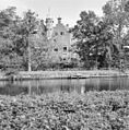
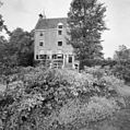
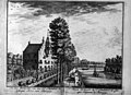
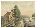
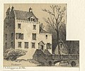
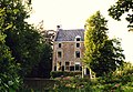
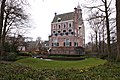
Nederlands: Oudaen (Oudaan) is een kasteel/ voormalige ridderhofstad gelegen aan de rivier de Vecht in het Utrechtse dorp Breukelen.
|
This is a category about rijksmonumentcomplex number 526627
|
Hoofdgebouw:
|
This is a category about rijksmonument number 526626
|
Parkaanleg:
|
This is a category about rijksmonument number 526628
|
Poortgebouw:
|
This is a category about rijksmonument number 526629
|
Bouwhuis (rechts):
|
This is a category about rijksmonument number 526630
|
Bouwhuis (links):
|
This is a category about rijksmonument number 526631
|
Boerderij:
|
This is a category about rijksmonument number 526632
|
Zomerhuis:
|
This is a category about rijksmonument number 526633
|
| Address |
|
Media in category "Oudaen, Breukelen"
The following 78 files are in this category, out of 78 total.
-
 Aanzicht - Breukelen - 20041960 - RCE.jpg 805 × 1,200; 277 KB
-
 Aanzicht - Breukelen - 20041961 - RCE.jpg 806 × 1,200; 251 KB
-
 Asser Oudaan.jpg 2,293 × 3,000; 616 KB
-
 Breukelen Oudaen 1.JPG 1,920 × 2,560; 1.88 MB
-
 Breukelen Oudaen 2.JPG 1,918 × 2,701; 4.08 MB
-
 Breukelen Oudaen 3.JPG 1,913 × 2,757; 4.49 MB
-
 Breukelen Oudaen 4.JPG 4,065 × 4,104; 12.22 MB
-
 Breukelen Oudaen 5.JPG 1,920 × 2,788; 5.85 MB
-
 Breukelen Oudaen 6.JPG 1,920 × 2,560; 1.84 MB
-
 Breukelen Oudaen 7.JPG 1,920 × 2,560; 1.75 MB
-
 Christian Zepp - Huis Oudaen, Near Breukelen - 54.213 - Detroit Institute of Arts.jpg 2,000 × 1,701; 1.24 MB
-
 Dutch Painting in the 19th Century - Bastert - Oudaen Castle.png 325 × 425; 94 KB
-
 Exterieur - Breukelen - 20041968 - RCE.jpg 1,200 × 813; 233 KB
-
 Exterieur - Breukelen - 20041969 - RCE.jpg 818 × 1,200; 295 KB
-
 Exterieur - Breukelen - 20041970 - RCE.jpg 1,200 × 813; 292 KB
-
 Exterieur - Breukelen - 20041971 - RCE.jpg 1,200 × 811; 344 KB
-
 Exterieur - Breukelen - 20041972 - RCE.jpg 814 × 1,200; 247 KB
-

-
 Exterieur INGANGSPARTIJ MET OPHAALBRUG - Breukelen - 20301425 - RCE.jpg 1,197 × 1,200; 392 KB
-
 Exterieur OVERZICHT - Breukelen - 20311237 - RCE.jpg 1,185 × 1,200; 454 KB
-
 Exterieur OVERZICHT ACHTERGEVEL - Breukelen - 20311236 - RCE.jpg 1,195 × 1,200; 449 KB
-
 Exterieur TEKENING (R. ROGHMAN) - Breukelen - 20260986 - RCE.jpg 1,200 × 791; 216 KB
-
 Gezicht op huis Oudaan bij Breukelen aan de Vecht, RP-F-AB12279-AL.jpg 3,004 × 3,930; 1.55 MB
-
 Gezicht op huis Oudaan bij Breukelen aan de Vecht, RP-F-AB12279-AM.jpg 3,020 × 3,952; 1.34 MB
-
 Gezicht op huis Oudaan langs de Vecht, RP-F-AB12280-U.jpg 3,888 × 3,098; 1.44 MB
-
 Gezicht op kasteel Oudaan, RP-T-1888-A-1777.jpg 6,354 × 4,638; 4.7 MB
-
 Gravure van Huis Oudaen - Breukelen - 20041963 - RCE.jpg 1,200 × 875; 310 KB
-

-

-

-

-

-

-

-

-
 HUA-201728-Gezicht over de Vecht op het kasteel Oudaen bij Breukelen.jpg 3,543 × 2,447; 2.71 MB
-
 HUA-201729-Gezicht over de Vecht op het kasteel Oudaen bij Breukelen.jpg 3,606 × 2,611; 3 MB
-

-
 HUA-201731-Gezicht op de voor en achtergevel van het kasteel Oudaen bij Breukelen.jpg 3,543 × 2,430; 2.38 MB
-

-
-

-

-

-
 HUA-201769-Gezicht over de Vecht op het huis Oudaen bij Breukelen.jpg 3,578 × 2,877; 2.95 MB
-
-

-
 HUA-206345-Gezicht op de toegangsbrug tot het kasteel Oudaen bij Breukelen.jpg 3,898 × 3,065; 3.65 MB
-
 Huis Oudaan met op de voorgrond een hengelaar, RP-T-1935-41.jpg 6,290 × 5,078; 3.19 MB
-
 Kasteel Oudaen - WLM 2011 - ednl.jpg 2,736 × 3,648; 4.44 MB
-

-

-
 Kasteel Oudaen, interieur hijswiel kap noordvleugel - Breukelen - 20042011 - RCE.jpg 1,192 × 1,200; 311 KB
-
 Kasteel Oudaen, interieur hijswiel kap noordvleugel - Breukelen - 20042012 - RCE.jpg 1,190 × 1,200; 237 KB
-
 Kasteel Oudaen, interieur kap zuidvleugel - Breukelen - 20042017 - RCE.jpg 1,200 × 1,195; 281 KB
-
 Kasteel Oudaen, interieur kapconstructie noordvleugel - Breukelen - 20042010 - RCE.jpg 1,197 × 1,200; 299 KB
-
 Kasteel Oudaen, interieur kapconstructie zuidgevel - Breukelen - 20042015 - RCE.jpg 1,197 × 1,200; 316 KB
-
 Kasteel Oudaen, interieur kapconstructie zuidvleugel - Breukelen - 20042014 - RCE.jpg 1,195 × 1,200; 312 KB
-
 Kasteel Oudaen, interieur kapconstructie zuidvleugel - Breukelen - 20042016 - RCE.jpg 1,193 × 1,200; 330 KB
-
 Kasteel Oudaen, interieur kapconstructie zuidvleugel - Breukelen - 20042018 - RCE.jpg 1,192 × 1,200; 298 KB
-
 Kasteel Oudaen, interieur kapconstructie zuidvleugel - Breukelen - 20042019 - RCE.jpg 1,195 × 1,200; 280 KB
-
 Kasteel Oudaen, interieur kapconstructie zuidvleugel - Breukelen - 20042021 - RCE.jpg 1,200 × 1,197; 305 KB
-
 La Maison Oudaan, du Sr Philibert de Clerqué, Seigneur de Bonenge, objectnr A 57542.jpg 1,323 × 1,006; 1.05 MB
-
 Omgeving Breukelen Jacob Olie (max res).jpg 4,961 × 3,772; 3.69 MB
-
 Oudaen tuin.jpg 2,142 × 1,476; 736 KB
-
 Oudaen-1.jpg 999 × 1,500; 757 KB
-
 Oudaen-2.jpg 1,500 × 1,000; 750 KB
-
 Overzicht Huis Oudaen circa 1856 - Breukelen - 20041967 - RCE.jpg 963 × 1,200; 224 KB
-
 Overzicht Huis Oudaen gelegen aan de Vecht - Breukelen - 20041965 - RCE.jpg 894 × 1,200; 245 KB
-

-
 Rijksmonument-526626-Oudaen-gracht.jpg 2,592 × 3,456; 2.66 MB
-
 Rijksmonument-526626-Oudaen.jpg 2,592 × 3,456; 2.54 MB
-
 Tekening van Huis Oudaen - Breukelen - 20041959 - RCE.jpg 1,200 × 949; 352 KB
-
 Tekening van Huis Oudaen, 17e eeuw - Breukelen - 20041962 - RCE.jpg 1,070 × 715; 180 KB
-
 Voorgevel met ophaalbrug en gracht - Breukelen - 20041966 - RCE.jpg 1,200 × 894; 285 KB
-
 Wapen-Oudaan.jpg 248 × 332; 21 KB
-
 Woning - Breukelen - 20490294 - RCE.jpg 1,200 × 900; 250 KB
-
 Woning - Breukelen - 20490295 - RCE.jpg 1,200 × 900; 204 KB


_-_Breukelen_-_20260986_-_RCE.jpg)


.jpg)


