Category:Oude Kerk, Oosterbeek
Jump to navigation
Jump to search
| Object location | | View all coordinates using: OpenStreetMap |
|---|
church building in Renkum, Netherlands  | |||||
| Upload media | |||||
| Instance of | |||||
|---|---|---|---|---|---|
| Location | Oosterbeek, Gelderland, Netherlands | ||||
| Street address |
| ||||
| Located on street |
| ||||
| Heritage designation |
| ||||
 | |||||
Nederlands: Oude Kerk, Oosterbeek - anno 10e eeuw
|
This is a category about rijksmonument number 32432
|
| Address |
|
Subcategories
This category has only the following subcategory.
Media in category "Oude Kerk, Oosterbeek"
The following 111 files are in this category, out of 111 total.
-

-
 75TH ANNIVERSARY OF OPERATION MARKET GARDEN 17.jpg 4,480 × 6,720; 3.32 MB
-
 75TH ANNIVERSARY OF OPERATION MARKET GARDEN 18.jpg 6,214 × 4,096; 1.99 MB
-
 75TH ANNIVERSARY OF OPERATION MARKET GARDEN 19.jpg 3,753 × 4,480; 1.96 MB
-
 75TH ANNIVERSARY OF OPERATION MARKET GARDEN 20.jpg 3,874 × 1,844; 975 KB
-
 75TH ANNIVERSARY OF OPERATION MARKET GARDEN 23.jpg 6,720 × 4,480; 2.47 MB
-

-
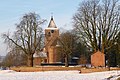
 De Oude Kerk te Oosterbeek.jpg 5,012 × 3,759; 16.95 MB
-
 De Oude Kerk te Oosterbeek2.jpg 3,594 × 5,476; 18.35 MB
-
 De Oude Kerk te Oosterbeek3.jpg 6,410 × 5,089; 26.43 MB
-
 De Oude Kerk te Oosterbeek4.jpg 6,709 × 5,389; 33.02 MB
-
 Deel van de noordgevel exterieur - Oosterbeek - 20173894 - RCE.jpg 958 × 1,200; 356 KB
-
 Doopvont en avondmaalstafel in kerk te Oosterbeek, Bestanddeelnr 904-1709.jpg 3,233 × 2,503; 1.99 MB
-
 Doopvont en avondmaalstafel in kerk te Oosterbeek, Bestanddeelnr 904-1710.jpg 3,233 × 2,488; 1.39 MB
-
 Doopvont en avondmaalstafel in kerk te Oosterbeek, Bestanddeelnr 904-1711.jpg 3,233 × 2,512; 1.71 MB
-
 Doopvont en tafel geschonken door de geallieerden, Bestanddeelnr 048-0479.jpg 2,170 × 3,255; 834 KB
-

-
 Exterieur - Oosterbeek - 20173865 - RCE.jpg 1,200 × 1,194; 433 KB
-
 Exterieur - Oosterbeek - 20173866 - RCE.jpg 1,200 × 1,190; 493 KB
-
 Exterieur OVERZICHT ZUIDGEVEL - Oosterbeek - 20339649 - RCE.jpg 1,200 × 940; 300 KB
-
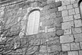
 Exterieur TUFSTEEN, DETAIL - Oosterbeek - 20294588 - RCE.jpg 1,190 × 1,200; 582 KB
-
 Exterieur zuid-gevel - Oosterbeek - 20173874 - RCE.jpg 1,200 × 952; 286 KB
-
 Gedeelte noordgevel - Oosterbeek - 20173869 - RCE.jpg 1,200 × 1,190; 470 KB
-
 Gedeelte noordgevel - Oosterbeek - 20173870 - RCE.jpg 1,196 × 1,200; 470 KB
-
 Gedeelte noordgevel - Oosterbeek - 20173871 - RCE.jpg 1,200 × 1,197; 520 KB
-
 Gedeelte noordgevel - Oosterbeek - 20173872 - RCE.jpg 1,200 × 1,177; 512 KB
-
 Gedeelte noordgevel - Oosterbeek - 20173873 - RCE.jpg 1,200 × 1,184; 486 KB
-

-
 Gedeelte zuid-gevel - Oosterbeek - 20173867 - RCE.jpg 1,200 × 1,194; 488 KB
-
 Gedeelte zuid-gevel - Oosterbeek - 20173868 - RCE.jpg 1,200 × 1,190; 474 KB
-
 Gevel van het schip - interieur - Oosterbeek - 20173886 - RCE.jpg 947 × 1,200; 183 KB
-
 Gevel van het schip - interieur - Oosterbeek - 20173887 - RCE.jpg 994 × 1,200; 186 KB
-
 Gevel van het schip - interieur - Oosterbeek - 20173888 - RCE.jpg 972 × 1,200; 230 KB
-
 Gevel van het schip - interieur - Oosterbeek - 20173889 - RCE.jpg 1,017 × 1,200; 243 KB
-
 Gevel van het schip - interieur - Oosterbeek - 20173890 - RCE.jpg 982 × 1,200; 169 KB
-
 Gevel van het schip - interieur - Oosterbeek - 20173891 - RCE.jpg 997 × 1,200; 174 KB
-
 Gevel van het schip - interieur - Oosterbeek - 20173892 - RCE.jpg 995 × 1,200; 207 KB
-
 Gevel van het schip - interieur - Oosterbeek - 20173893 - RCE.jpg 984 × 1,200; 184 KB
-
 Gezicht op de toren - Oosterbeek - 20173895 - RCE.jpg 847 × 1,200; 263 KB
-
 Hundreds of gooses at the Rhine riverforeland in front of the church - panoramio.jpg 4,928 × 3,264; 7.83 MB
-
 Ingangspartij in de noordgevel, interieur - Oosterbeek - 20173880 - RCE.jpg 958 × 1,200; 273 KB
-
 Interieur naar 't koor - Oosterbeek - 20173906 - RCE.jpg 1,192 × 1,200; 262 KB
-
 Interieur naar 't westen - Oosterbeek - 20173908 - RCE.jpg 1,198 × 1,200; 209 KB
-
 Interieur naar het oosten - Oosterbeek - 20173876 - RCE.jpg 944 × 1,200; 184 KB
-
 Interieur naar het westen - Oosterbeek - 20173875 - RCE.jpg 949 × 1,200; 189 KB
-
 Interieur naar het westen - Oosterbeek - 20173907 - RCE.jpg 1,184 × 1,200; 256 KB
-

-

-
 Kerk - Oosterbeek - 20173860 - RCE.jpg 918 × 1,200; 248 KB
-
 Kerk - Oosterbeek - 20173861 - RCE.jpg 960 × 1,200; 304 KB
-
 Kerk en pastorie vanuit het noord-westen - Oosterbeek - 20173881 - RCE.jpg 1,200 × 1,200; 325 KB
-
 Kerk en pastorie vanuit het noord-westen - Oosterbeek - 20173882 - RCE.jpg 1,200 × 1,200; 301 KB
-
 Kerk vanuit het oosten - Oosterbeek - 20173864 - RCE.jpg 1,200 × 869; 203 KB
-
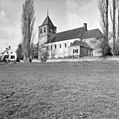
 Kerk vanuit het zuiden - Oosterbeek - 20173863 - RCE.jpg 1,200 × 874; 259 KB
-
 Kerk, detail muur, reproductie van foto - Oosterbeek - 20173885 - RCE.jpg 1,200 × 859; 284 KB
-
 Kerk, detail reproductie van foto - Oosterbeek - 20173884 - RCE.jpg 839 × 1,200; 273 KB
-
 Kerk, reproductie van tekening - Oosterbeek - 20173883 - RCE.jpg 1,200 × 828; 147 KB
-

-
 Middendeel van de noordgevel, exterieur - Oosterbeek - 20173862 - RCE.jpg 1,200 × 967; 350 KB
-
 Middenvak van de zuid-gevel - Oosterbeek - 20173878 - RCE.jpg 962 × 1,200; 377 KB
-
 Noordzijde na restauratie - Oosterbeek - 20173897 - RCE.jpg 1,200 × 800; 317 KB
-
 Noordzijde na restauratie - Oosterbeek - 20173898 - RCE.jpg 1,200 × 800; 281 KB
-
 Noordzijde na restauratie - Oosterbeek - 20173901 - RCE.jpg 1,200 × 783; 292 KB
-
 Noordzijde na restauratie - Oosterbeek - 20173902 - RCE.jpg 1,200 × 786; 316 KB
-
 Noordzijde na restauratie - Oosterbeek - 20173903 - RCE.jpg 1,200 × 782; 287 KB
-

-
 Oost deel van de zuid-gevel - Oosterbeek - 20173879 - RCE.jpg 957 × 1,200; 374 KB
-
 Oosterbeek kerk 1905.jpg 640 × 480; 53 KB
-
 Oosterbeek, de Oude Kerk RM32432 IMG 4215 2020-04-08 09.09.jpg 5,125 × 3,201; 13.32 MB
-
 Oosterbeek, Netherlands - panoramio (15).jpg 1,375 × 2,048; 783 KB
-
 Oosterbeek, Netherlands - panoramio (38).jpg 2,048 × 1,155; 782 KB
-
 Oosterbeek, Netherlands - panoramio (40).jpg 2,048 × 1,155; 761 KB
-
 Oosterbeek, Netherlands - panoramio (49).jpg 2,048 × 1,155; 698 KB
-
 Oosterbeek, Netherlands - panoramio (50).jpg 2,048 × 1,155; 554 KB
-
 Oosterbeek, Netherlands - panoramio (51).jpg 2,048 × 1,155; 867 KB
-
 Oosterbeek, Netherlands - panoramio (55).jpg 2,048 × 1,155; 587 KB
-
 Oosterbeek, Netherlands - panoramio (6).jpg 2,048 × 1,375; 539 KB
-
 Oosterbeek, Netherlands - panoramio (61).jpg 4,896 × 3,264; 3.79 MB
-
 Oosterbeek, Netherlands - panoramio (62).jpg 4,896 × 3,264; 3.66 MB
-
 Oosterbeek, Netherlands - panoramio (63).jpg 4,896 × 3,264; 2.3 MB
-
 Oosterbeek, Netherlands - panoramio (65).jpg 4,896 × 3,264; 4.67 MB
-
 Oosterbeek, Netherlands - panoramio (66).jpg 4,896 × 3,264; 3.52 MB
-
 Oosterbeek-nhkerk-zuil.JPG 1,200 × 1,600; 339 KB
-
 Oosterbeek-oude-kerk-lindeboom.JPG 1,600 × 1,200; 373 KB
-
 Oude kerk (PKN) Oosterbeek 2008.jpg 2,304 × 1,954; 820 KB
-

-
 Oude Kerk Oosterbeek.JPG 4,608 × 3,456; 4.28 MB
-

-

-

-

-

-
 Overzicht van de zuidgevel met kerktoren - Oosterbeek - 20383706 - RCE.jpg 1,200 × 1,200; 297 KB
-

-

-
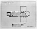 Plattegrond - Oosterbeek - 20173858 - RCE.jpg 1,200 × 943; 175 KB
-

-

-

-

-
 The old church Oosterbeek - panoramio.jpg 2,896 × 1,936; 2.86 MB
-

-

-
 Toren naar het oosten - Oosterbeek - 20173859 - RCE.jpg 953 × 1,200; 297 KB
-
-
 Vredespaal Oude kerk Oosterbeek.jpg 900 × 1,600; 335 KB
-
 Zuid-gevel west deel - Oosterbeek - 20173877 - RCE.jpg 966 × 1,200; 377 KB
-
 Zuid-west gevel - Oosterbeek - 20173905 - RCE.jpg 1,188 × 1,200; 459 KB
-
 Zuidgevel - Oosterbeek - 20173904 - RCE.jpg 1,195 × 1,200; 439 KB
-
 Zuidzijde na restauratie - Oosterbeek - 20173899 - RCE.jpg 1,200 × 797; 342 KB
-
 Zuidzijde na restauratie - Oosterbeek - 20173900 - RCE.jpg 1,200 × 800; 370 KB
_with_a_nice_tree._An_Airborne_memorial._The_soldiers_of_the_Battle_of_Arnhem_called_it_%22Old_Kirk%22_-_panoramio.jpg)


,_mirrored_in_the_flooded_Rhine_river_foreland,_called_PKN_%22Oude_kerk_Oosterbeek%22_The_soldiers_called_it_%22Old_Kirk%22_-_panoramio.jpg)


.jpg)
.jpg)
.jpg)
.jpg)
.jpg)
.jpg)
.jpg)
.jpg)
.jpg)
.jpg)
.jpg)
.jpg)
.jpg)


_Oosterbeek_2008.jpg)


_%22Old_church%22_founded_in_10th_century_Oosterbeek,_called_%22Oude_kerk_Oosterbeek%22_A_memorial_of_the_Battle_of_Arnhem_in_September_1944._The_soldiers_called_it_%22Old_Kirk%22_-_panoramio.jpg)
_Old_Church_in_winter_with_lots_of_goose_in_the_Rhine_riverforeland,_called_%22Oude_kerk_Oosterbeek%22_At_the_%22Battle_of_Arnhem%22_it_was_a_shelter._The_soldiers_called_it_%22Old_Kirk%22_-_panoramio.jpg)


_called_%22Oude_kerk_Oosterbeek%22_The_soldiers_called_it_%22Old_Kirk%22_-_panoramio.jpg)


